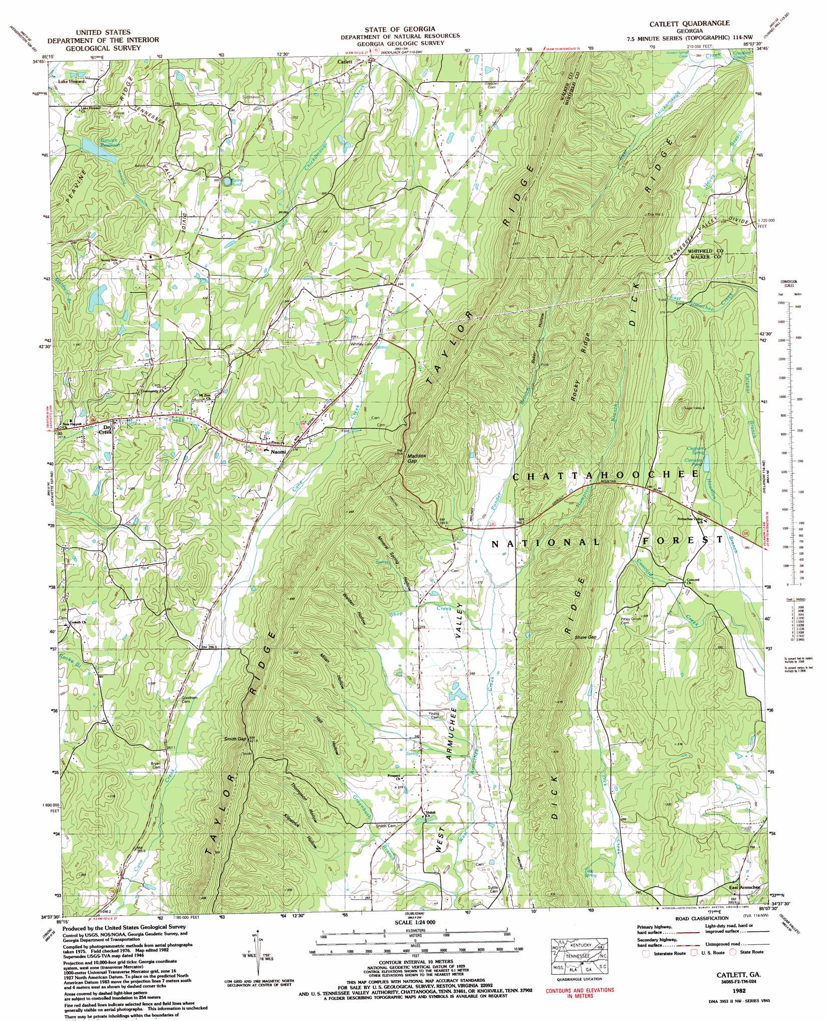
Catlett Topo Map Georgia
To zoom in, hover over the map of Catlett
USGS Topo Quad 34085f2 - 1:24,000 scale
| Topo Map Name: | Catlett |
| USGS Topo Quad ID: | 34085f2 |
| Print Size: | ca. 21 1/4" wide x 27" high |
| Southeast Coordinates: | 34.625° N latitude / 85.125° W longitude |
| Map Center Coordinates: | 34.6875° N latitude / 85.1875° W longitude |
| U.S. State: | GA |
| Filename: | o34085f2.jpg |
| Download Map JPG Image: | Catlett topo map 1:24,000 scale |
| Map Type: | Topographic |
| Topo Series: | 7.5´ |
| Map Scale: | 1:24,000 |
| Source of Map Images: | United States Geological Survey (USGS) |
| Alternate Map Versions: |
Catlett GA 1935 Download PDF Buy paper map Catlett GA 1946, updated 1962 Download PDF Buy paper map Catlett GA 1946, updated 1975 Download PDF Buy paper map Catlett GA 1947, updated 1947 Download PDF Buy paper map Catlett GA 1982, updated 1983 Download PDF Buy paper map Catlett GA 2011 Download PDF Buy paper map Catlett GA 2014 Download PDF Buy paper map |
| FStopo: | US Forest Service topo Catlett is available: Download FStopo PDF Download FStopo TIF |
1:24,000 Topo Quads surrounding Catlett
Hooker |
Fort Oglethorpe |
East Ridge |
Ringgold |
Cohutta |
Durham |
Kensington |
Nickajack Gap |
Tunnel Hill |
Dalton North |
Cedar Grove |
Estelle |
Catlett |
Villanow |
Dalton South |
Dougherty Gap |
Trion |
Subligna |
Sugar Valley |
Calhoun North |
Lyerly |
Summerville |
Armuchee |
Plainville |
Calhoun South |
> Back to 34085e1 at 1:100,000 scale
> Back to 34084a1 at 1:250,000 scale
> Back to U.S. Topo Maps home
Catlett topo map: Gazetteer
Catlett: Dams
Abney Lake Dam elevation 315m 1033′Barwick Mill Dam Two elevation 268m 879′
Barwick Mills Lake Dam elevation 268m 879′
Scott Lake Dam elevation 275m 902′
Catlett: Gaps
Gordon Spring Gap elevation 424m 1391′Maddox Gap elevation 382m 1253′
Shaw Gap elevation 352m 1154′
Smith Gap elevation 420m 1377′
Wood Gap elevation 317m 1040′
Catlett: Lakes
Round Pond elevation 300m 984′Catlett: Populated Places
Catlett elevation 270m 885′Chestnutflat (historical) elevation 281m 921′
Corinth elevation 277m 908′
East Armuchee elevation 279m 915′
Greenbush (historical) elevation 258m 846′
Naomi elevation 278m 912′
Suttles Mill elevation 253m 830′
Catlett: Reservoirs
Abney Lake elevation 315m 1033′Barwick Reservoir elevation 275m 902′
Clements Pond elevation 281m 921′
Lake Howard elevation 259m 849′
Catlett: Ridges
Dick Ridge elevation 372m 1220′Rocky Ridge elevation 416m 1364′
Catlett: Springs
Cleghorn Spring elevation 286m 938′Crawford Spring elevation 277m 908′
Howard Lake Spring elevation 265m 869′
Tate Spring elevation 277m 908′
Catlett: Streams
Gordon Spring Creek elevation 279m 915′Greenbush Branch elevation 247m 810′
Hampton Branch elevation 258m 846′
Ponder Branch elevation 269m 882′
Shop Creek elevation 255m 836′
Catlett: Valleys
Hall Hollow elevation 262m 859′Kilpatrick Hollow elevation 273m 895′
Milan Hollow elevation 269m 882′
Mineral Spring Hollow elevation 277m 908′
Thompson Hollow elevation 270m 885′
Walden Hollow elevation 270m 885′
Catlett digital topo map on disk
Buy this Catlett topo map showing relief, roads, GPS coordinates and other geographical features, as a high-resolution digital map file on DVD: