Tunnel Hill Topo Map Georgia
To zoom in, hover over the map of Tunnel Hill
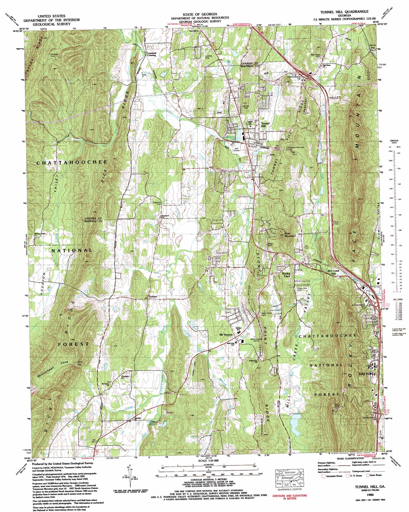
USGS Topo Quad 34085g1 - 1:24,000 scale
| Topo Map Name: | Tunnel Hill |
| USGS Topo Quad ID: | 34085g1 |
| Print Size: | ca. 21 1/4" wide x 27" high |
| Southeast Coordinates: | 34.75° N latitude / 85° W longitude |
| Map Center Coordinates: | 34.8125° N latitude / 85.0625° W longitude |
| U.S. State: | GA |
| Filename: | o34085g1.jpg |
| Download Map JPG Image: | Tunnel Hill topo map 1:24,000 scale |
| Map Type: | Topographic |
| Topo Series: | 7.5´ |
| Map Scale: | 1:24,000 |
| Source of Map Images: | United States Geological Survey (USGS) |
| Alternate Map Versions: |
Tunnel Hill GA 1935 Download PDF Buy paper map Tunnel Hill GA 1943, updated 1946 Download PDF Buy paper map Tunnel Hill GA 1943, updated 1960 Download PDF Buy paper map Tunnel Hill GA 1943, updated 1965 Download PDF Buy paper map Tunnel Hill GA 1943, updated 1976 Download PDF Buy paper map Tunnel Hill GA 1983, updated 1983 Download PDF Buy paper map Tunnel Hill GA 2011 Download PDF Buy paper map Tunnel Hill GA 2014 Download PDF Buy paper map |
| FStopo: | US Forest Service topo Tunnel Hill is available: Download FStopo PDF Download FStopo TIF |
1:24,000 Topo Quads surrounding Tunnel Hill
Chattanooga |
East Chattanooga |
Ooltewah |
Mcdonald |
Felker |
Fort Oglethorpe |
East Ridge |
Ringgold |
Cohutta |
Beaverdale |
Kensington |
Nickajack Gap |
Tunnel Hill |
Dalton North |
Chatsworth |
Estelle |
Catlett |
Villanow |
Dalton South |
Calhoun Ne |
Trion |
Subligna |
Sugar Valley |
Calhoun North |
Redbud |
> Back to 34085e1 at 1:100,000 scale
> Back to 34084a1 at 1:250,000 scale
> Back to U.S. Topo Maps home
Tunnel Hill topo map: Gazetteer
Tunnel Hill: Bays
McCutcheon Cove elevation 293m 961′Tunnel Hill: Crossings
Interchange 136 elevation 270m 885′Interchange 137 elevation 225m 738′
Interchange 138 elevation 268m 879′
Tunnel Hill: Dams
Cobblestone Lake Dam elevation 250m 820′Griffin Lake Dam elevation 248m 813′
Mill Creek Watershed Dam Number 10 elevation 239m 784′
Mill Creek Watershed Dam Number Seven elevation 241m 790′
Tunnel Hill: Gaps
Cove Gap elevation 297m 974′Harris Gap elevation 276m 905′
Mill Creek Gap elevation 230m 754′
Rays Gap elevation 444m 1456′
Tunnel Hill: Populated Places
Callaway Mill elevation 247m 810′Copeland Crossing elevation 241m 790′
Hassler Mill elevation 224m 734′
Mount Vernon elevation 283m 928′
Rocky Face elevation 235m 770′
Trickum elevation 275m 902′
Tunnel Hill elevation 256m 839′
Tunnel Hill: Post Offices
Rocky Face Post Office elevation 231m 757′Tunnel Hill Post Office elevation 259m 849′
Tunnel Hill: Reservoirs
Cobblestone Lake elevation 250m 820′Cook Lake (historical) elevation 266m 872′
Gillilan Lake elevation 239m 784′
Griffin Lake elevation 248m 813′
Hiawassee Land Company Lake elevation 241m 790′
Meadow Lake elevation 255m 836′
Tunnel Hill: Ridges
Stony Point Ridge elevation 314m 1030′Tunnel Hill Ridge elevation 321m 1053′
Tunnel Hill: Springs
Freeman Spring elevation 262m 859′Tunnel Hill: Streams
Bell Branch elevation 249m 816′Cove Creek elevation 255m 836′
Dry Creek elevation 238m 780′
Hopkins Branch elevation 252m 826′
Mount Vernon Creek elevation 246m 807′
North Fork Mill Creek elevation 223m 731′
Tanyard Creek elevation 243m 797′
Tunnel Hill: Summits
Blue Mountain elevation 401m 1315′Rocky Face Mountain elevation 482m 1581′
Tunnel Hill: Tunnels
Chetoogeta Mountain Tunnel elevation 307m 1007′Tunnel Hill: Valleys
Dogwood Valley elevation 243m 797′Houston Valley elevation 260m 853′
Mill Creek Valley elevation 226m 741′
Tunnel Hill digital topo map on disk
Buy this Tunnel Hill topo map showing relief, roads, GPS coordinates and other geographical features, as a high-resolution digital map file on DVD: