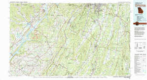
Chickamauga Topo Map Georgia

To zoom in, hover over the map of Chickamauga

USGS Topo Map 34085e1 - 1:100,000 scale

Topo Map Name: Chickamauga
USGS Topo Quad ID: 34085e1
Print Size: ca. 39" wide x 24" high
Southeast Coordinates: 34.5° N latitude / 85° W longitude
Map Center Coordinates: 34.75° N latitude / 85.5° W longitude
U.S. States: GA, AL, TN
Filename: 34085e1.jpg
Download Map JPG Image: Chickamauga topo map 1:100,000 scale
Map Type: Topographic
Topo Series: 30´x60´
Map Scale: 1:100,000
Source of Map Images: United States Geological Survey (USGS)
Alternate Map Versions: Chickamauga GA 1981, updated 1982 Download PDF Buy paper map
Chickamauga GA 1981, updated 1982 Download PDF Buy paper map

1:100,000 Topos surrounding Chickamauga

Tullahoma
Tullahoma USGS topographic map 35086a1
Chattanooga
Chattanooga USGS topographic map 35085a1
Cleveland
Cleveland USGS topographic map 35084a1
Huntsville
Huntsville USGS topographic map 34086e1
Chickamauga
Chickamauga USGS topographic map 34085e1
Dalton
Dalton USGS topographic map 34084e1
Guntersville
Guntersville USGS topographic map 34086a1
Rome
Rome USGS topographic map 34085a1
Cartersville
Cartersville USGS topographic map 34084a1

> Back to 34084a1 at 1:250,000 scale
> Back to U.S. Topo Maps home

1:24,000 Topo Quads covered by the spatial extent of this 100k map (Chickamauga)

Eureka
Eureka USGS topographic map 34085h8
Doran Cove
Doran Cove USGS topographic map 34085h7
Bridgeport
Bridgeport USGS topographic map 34085h6
New Home
New Home USGS topographic map 34085h5
Hooker
Hooker USGS topographic map 34085h4
Fort Oglethorpe
Fort Oglethorpe USGS topographic map 34085h3
East Ridge
East Ridge USGS topographic map 34085h2
Ringgold
Ringgold USGS topographic map 34085h1
Wannville
Wannville USGS topographic map 34085g8
Stevenson
Stevenson USGS topographic map 34085g7
Flat Rock
Flat Rock USGS topographic map 34085g6
Trenton
Trenton USGS topographic map 34085g5
Durham
Durham USGS topographic map 34085g4
Kensington
Kensington USGS topographic map 34085g3
Nickajack Gap
Nickajack Gap USGS topographic map 34085g2
Tunnel Hill
Tunnel Hill USGS topographic map 34085g1
Hollywood
Hollywood USGS topographic map 34085f8
Henagar
Henagar USGS topographic map 34085f7
Ider
Ider USGS topographic map 34085f6
Sulphur Springs
Sulphur Springs USGS topographic map 34085f5
Cedar Grove
Cedar Grove USGS topographic map 34085f4
Estelle
Estelle USGS topographic map 34085f3
Catlett
Catlett USGS topographic map 34085f2
Villanow
Villanow USGS topographic map 34085f1
Dutton
Dutton USGS topographic map 34085e8
Sylvania
Sylvania USGS topographic map 34085e7
Dugout Valley
Dugout Valley USGS topographic map 34085e6
Valley Head
Valley Head USGS topographic map 34085e5
Dougherty Gap
Dougherty Gap USGS topographic map 34085e4
Trion
Trion USGS topographic map 34085e3
Subligna
Subligna USGS topographic map 34085e2
Sugar Valley
Sugar Valley USGS topographic map 34085e1
Chickamauga topographical map