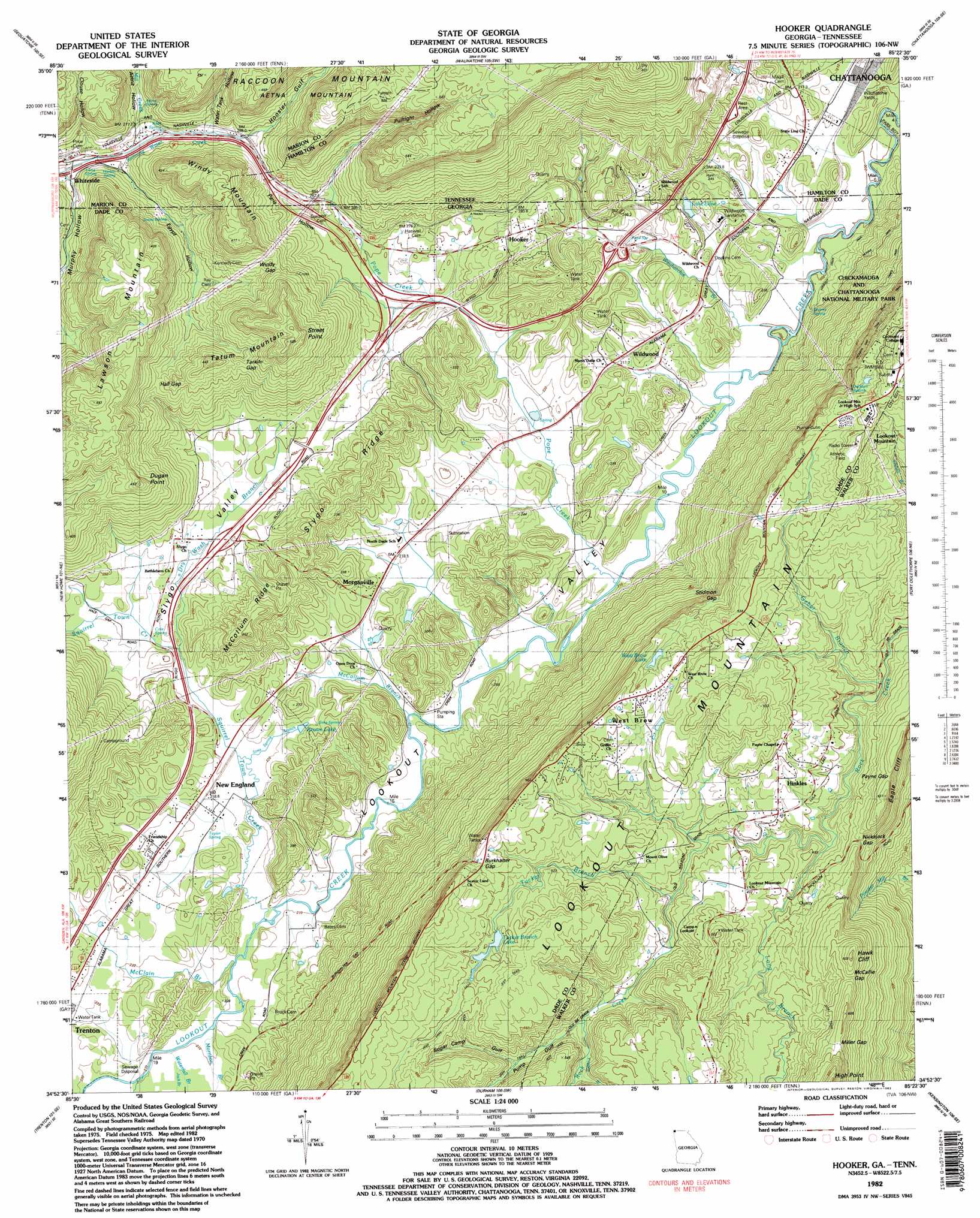
Hooker Topo Map Georgia
To zoom in, hover over the map of Hooker
USGS Topo Quad 34085h4 - 1:24,000 scale
| Topo Map Name: | Hooker |
| USGS Topo Quad ID: | 34085h4 |
| Print Size: | ca. 21 1/4" wide x 27" high |
| Southeast Coordinates: | 34.875° N latitude / 85.375° W longitude |
| Map Center Coordinates: | 34.9375° N latitude / 85.4375° W longitude |
| U.S. States: | GA, TN |
| Filename: | o34085h4.jpg |
| Download Map JPG Image: | Hooker topo map 1:24,000 scale |
| Map Type: | Topographic |
| Topo Series: | 7.5´ |
| Map Scale: | 1:24,000 |
| Source of Map Images: | United States Geological Survey (USGS) |
| Alternate Map Versions: |
Hooker GA 1945, updated 1954 Download PDF Buy paper map Hooker GA 1945, updated 1968 Download PDF Buy paper map Hooker GA 1946, updated 1947 Download PDF Buy paper map Hooker GA 1946, updated 1947 Download PDF Buy paper map Hooker GA 1970, updated 1972 Download PDF Buy paper map Hooker GA 1982, updated 1983 Download PDF Buy paper map Hooker GA 2010 Download PDF Buy paper map Hooker GA 2014 Download PDF Buy paper map |
1:24,000 Topo Quads surrounding Hooker
White City |
Whitwell |
Ketner Gap |
Fairmount |
Daisy |
South Pittsburg |
Sequatchie |
Wauhatchie |
Chattanooga |
East Chattanooga |
Bridgeport |
New Home |
Hooker |
Fort Oglethorpe |
East Ridge |
Flat Rock |
Trenton |
Durham |
Kensington |
Nickajack Gap |
Ider |
Sulphur Springs |
Cedar Grove |
Estelle |
Catlett |
> Back to 34085e1 at 1:100,000 scale
> Back to 34084a1 at 1:250,000 scale
> Back to U.S. Topo Maps home
Hooker topo map: Gazetteer
Hooker: Capes
Dugan Point elevation 441m 1446′Hooker: Cliffs
Hawk Cliff elevation 581m 1906′High Point elevation 654m 2145′
Street Point elevation 483m 1584′
Hooker: Dams
Smythe Lake Dam elevation 234m 767′Tucker Branch Lake Dam elevation 535m 1755′
West Brow Lake Dam elevation 520m 1706′
Hooker: Gaps
Burkhalter Gap elevation 565m 1853′Hall Gap elevation 338m 1108′
McCallie Gap elevation 556m 1824′
Miller Gap elevation 592m 1942′
Nickajack Gap elevation 459m 1505′
Payne Gap elevation 474m 1555′
Stidmon Gap elevation 468m 1535′
Tarkiln Gap elevation 372m 1220′
Windy Gap elevation 355m 1164′
Hooker: Populated Places
Hinkles elevation 459m 1505′Hooker elevation 260m 853′
Jamesburg elevation 446m 1463′
Morganville elevation 222m 728′
New England elevation 220m 721′
West Brow elevation 554m 1817′
Whiteside elevation 246m 807′
Wildwood elevation 211m 692′
Hooker: Post Offices
Whiteside Post Office elevation 262m 859′Hooker: Reservoirs
Brown Lake elevation 225m 738′Lake Edna elevation 226m 741′
Lake Edna elevation 226m 741′
Smythe Lake elevation 234m 767′
Tucker Branch Lake elevation 535m 1755′
West Brow Lake elevation 520m 1706′
Hooker: Ridges
McCollum Ridge elevation 351m 1151′Slygo Ridge elevation 336m 1102′
Hooker: Springs
Aetna Spring elevation 278m 912′Cole Spring elevation 225m 738′
Harbin Spring elevation 251m 823′
Jackson Spring elevation 567m 1860′
Jones Spring elevation 273m 895′
Keef Spring elevation 274m 898′
Long Spring elevation 270m 885′
Pope Spring elevation 223m 731′
Sims Spring elevation 239m 784′
Skyuka Spring elevation 205m 672′
Taylor Spring elevation 212m 695′
Hooker: Streams
Dry Wash Branch elevation 219m 718′Fuggett Branch elevation 466m 1528′
Geber Branch elevation 398m 1305′
Jack Branch elevation 214m 702′
McClain Branch elevation 209m 685′
McCollum Branch elevation 205m 672′
Mill Creek elevation 255m 836′
Morrison Branch elevation 209m 685′
Murphy Hollow Creek elevation 238m 780′
Pope Creek elevation 204m 669′
Sims Spring Branch elevation 210m 688′
Sitton Gulch Creek elevation 211m 692′
Squirrel Town Creek elevation 209m 685′
Tucker Branch elevation 438m 1437′
Waterfall Branch elevation 210m 688′
Wauhatchie Branch elevation 200m 656′
Hooker: Summits
Lawson Mountain elevation 463m 1519′Tatum Mountain elevation 496m 1627′
Windy Mountain elevation 463m 1519′
Windy Mountain elevation 475m 1558′
Hooker: Trails
Skyuka Trail elevation 206m 675′Hooker: Valleys
Aetna Hollow elevation 275m 902′Clouse Hollow elevation 272m 892′
Egypt Hollow elevation 251m 823′
Egypt Hollow elevation 253m 830′
Hoosier Gulf elevation 293m 961′
Murphy Hollow elevation 240m 787′
Murphy Hollow elevation 243m 797′
Paris Hollow elevation 240m 787′
Paris Hollow elevation 248m 813′
Pulltight Hollow elevation 295m 967′
Pump Gulf elevation 460m 1509′
Slygo Valley elevation 218m 715′
Sugar Camp Gulf elevation 481m 1578′
Water Tank Hollow elevation 280m 918′
Hooker digital topo map on disk
Buy this Hooker topo map showing relief, roads, GPS coordinates and other geographical features, as a high-resolution digital map file on DVD: