Chapel Hill Topo Map Arkansas
To zoom in, hover over the map of Chapel Hill
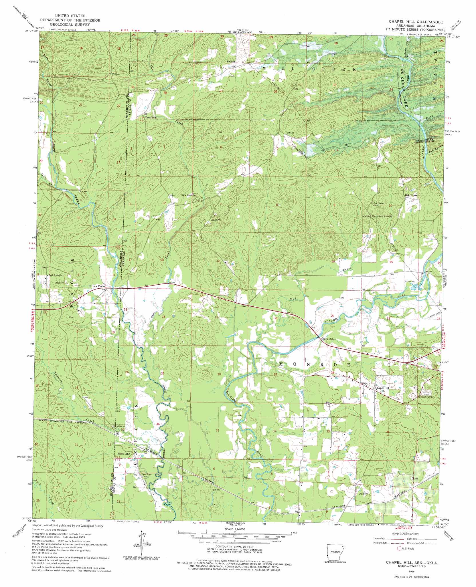
USGS Topo Quad 34094a4 - 1:24,000 scale
| Topo Map Name: | Chapel Hill |
| USGS Topo Quad ID: | 34094a4 |
| Print Size: | ca. 21 1/4" wide x 27" high |
| Southeast Coordinates: | 34° N latitude / 94.375° W longitude |
| Map Center Coordinates: | 34.0625° N latitude / 94.4375° W longitude |
| U.S. States: | AR, OK |
| Filename: | o34094a4.jpg |
| Download Map JPG Image: | Chapel Hill topo map 1:24,000 scale |
| Map Type: | Topographic |
| Topo Series: | 7.5´ |
| Map Scale: | 1:24,000 |
| Source of Map Images: | United States Geological Survey (USGS) |
| Alternate Map Versions: |
Chapel Hill AR 1965, updated 1967 Download PDF Buy paper map Chapel Hill AR 1965, updated 1978 Download PDF Buy paper map Chapel Hill AR 2011 Download PDF Buy paper map Chapel Hill AR 2014 Download PDF Buy paper map |
1:24,000 Topo Quads surrounding Chapel Hill
Hee Creek |
Big Hudson Creek |
Bog Springs |
Wickes |
Baker Springs |
Stephens Gap |
Toblerville |
De Queen Nw |
Gillham |
Gillham Dam |
Broken Bow |
Eagletown |
Chapel Hill |
De Queen |
Geneva |
Shults |
Goodwater |
Cerrogordo |
Horatio |
Lockesburg |
Haworth |
Bokhoma |
Arkinda |
Winthrop |
Falls Chapel |
> Back to 34094a1 at 1:100,000 scale
> Back to 34094a1 at 1:250,000 scale
> Back to U.S. Topo Maps home
Chapel Hill topo map: Gazetteer
Chapel Hill: Airports
J Lynn Helms Airport elevation 107m 351′Chapel Hill: Bridges
Johnson Bridge elevation 108m 354′Chapel Hill: Dams
De Queen Dam elevation 144m 472′Chapel Hill: Populated Places
Antrey (historical) elevation 159m 521′Chapel Hill elevation 132m 433′
Cheatham elevation 136m 446′
Kellum elevation 153m 501′
Oak Grove elevation 148m 485′
Ultima Thule elevation 110m 360′
Chapel Hill: Reservoirs
De Queen Lake elevation 144m 472′Chapel Hill: Streams
Bellah Creek elevation 132m 433′Cane Creek elevation 103m 337′
Mud Creek elevation 101m 331′
Pero Creek elevation 119m 390′
Prairie Branch elevation 116m 380′
Rock Creek elevation 96m 314′
Slate Creek elevation 115m 377′
Story Creek elevation 132m 433′
Twomile Creek elevation 99m 324′
Chapel Hill: Valleys
Glen Canyon elevation 113m 370′Chapel Hill digital topo map on disk
Buy this Chapel Hill topo map showing relief, roads, GPS coordinates and other geographical features, as a high-resolution digital map file on DVD: