Lawrenceburg Topo Map Tennessee
To zoom in, hover over the map of Lawrenceburg
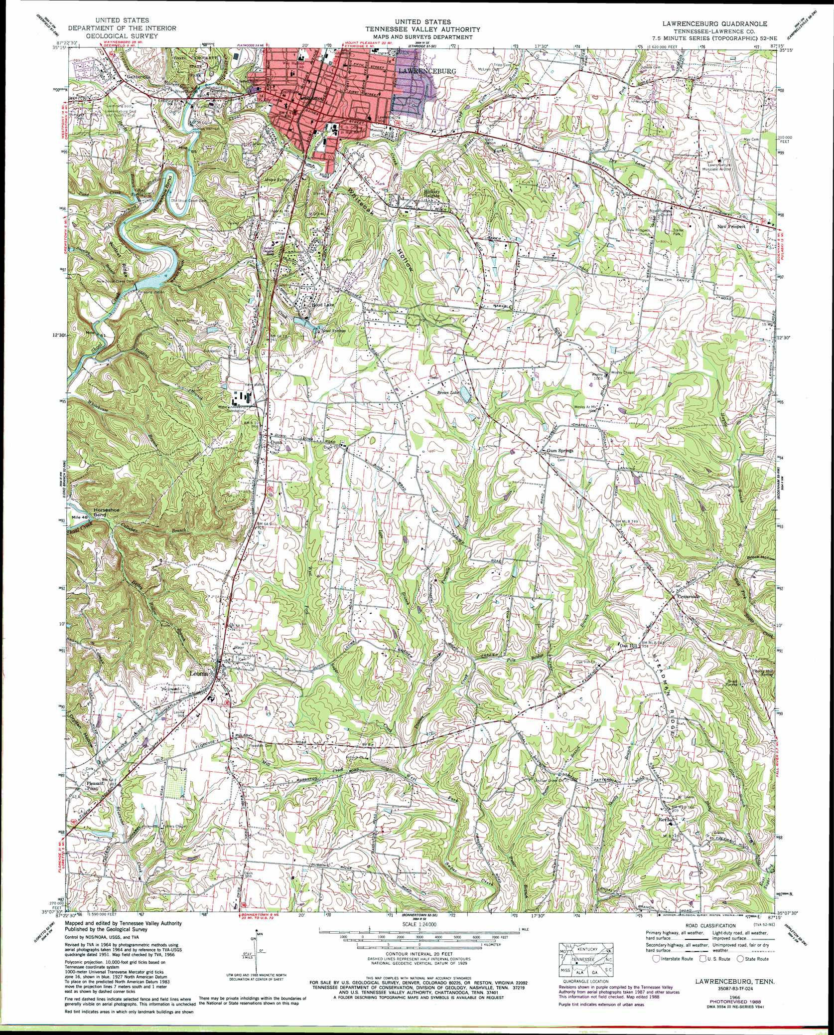
USGS Topo Quad 35087b3 - 1:24,000 scale
| Topo Map Name: | Lawrenceburg |
| USGS Topo Quad ID: | 35087b3 |
| Print Size: | ca. 21 1/4" wide x 27" high |
| Southeast Coordinates: | 35.125° N latitude / 87.25° W longitude |
| Map Center Coordinates: | 35.1875° N latitude / 87.3125° W longitude |
| U.S. State: | TN |
| Filename: | o35087b3.jpg |
| Download Map JPG Image: | Lawrenceburg topo map 1:24,000 scale |
| Map Type: | Topographic |
| Topo Series: | 7.5´ |
| Map Scale: | 1:24,000 |
| Source of Map Images: | United States Geological Survey (USGS) |
| Alternate Map Versions: |
Lawrenceburg TN 1936 Download PDF Buy paper map Lawrenceburg TN 1951, updated 1956 Download PDF Buy paper map Lawrenceburg TN 1966, updated 1969 Download PDF Buy paper map Lawrenceburg TN 1966, updated 1989 Download PDF Buy paper map Lawrenceburg TN 2010 Download PDF Buy paper map Lawrenceburg TN 2013 Download PDF Buy paper map Lawrenceburg TN 2016 Download PDF Buy paper map |
1:24,000 Topo Quads surrounding Lawrenceburg
Riverside |
Henryville |
Summertown |
Sandy Hook |
Lynnville |
Ovilla |
Deerfield |
Ethridge |
Campbellsville |
Milky Way |
Westpoint |
Long Branch |
Lawrenceburg |
Bodenham |
Pulaski |
Saint Joseph |
Loretto |
Bonnertown |
Appleton |
Aspen Hill |
Pruitton |
Center Hill |
Lexington |
Union Hill |
Salem |
> Back to 35087a1 at 1:100,000 scale
> Back to 35086a1 at 1:250,000 scale
> Back to U.S. Topo Maps home
Lawrenceburg topo map: Gazetteer
Lawrenceburg: Airports
Lawrenceburg Municipal Airport elevation 281m 921′Lawrenceburg: Bends
Horseshoe Bend elevation 234m 767′Horseshoe Bend elevation 207m 679′
Lawrenceburg: Cliffs
Raven Bluff elevation 228m 748′Lawrenceburg: Dams
New Shoal Creek Dam elevation 223m 731′Old Shoal Creek Dam elevation 237m 777′
Lawrenceburg: Populated Places
Antioch elevation 272m 892′Crossroads elevation 289m 948′
Dunn elevation 295m 967′
Fairview elevation 286m 938′
Gaitherville elevation 271m 889′
Gum Springs elevation 305m 1000′
Hickory Heights elevation 281m 921′
Hood Lake elevation 289m 948′
Lawrenceburg elevation 273m 895′
Leoma elevation 292m 958′
New Prospect elevation 283m 928′
Oak Hill elevation 289m 948′
Pleasant Point elevation 275m 902′
Revilo elevation 276m 905′
Richardson (historical) elevation 282m 925′
Rossboro elevation 265m 869′
Shady Grove (historical) elevation 248m 813′
Lawrenceburg: Post Offices
Lawrenceburg Post Office elevation 275m 902′Leoma Post Office elevation 289m 948′
Lawrenceburg: Reservoirs
Brown Lake elevation 289m 948′New Shoal Creek Reservoir elevation 223m 731′
Lawrenceburg: Ridges
Steadman Ridge elevation 286m 938′Wildcat Ridge elevation 255m 836′
Lawrenceburg: Springs
Brock Spring elevation 247m 810′Cherry Hill Spring elevation 245m 803′
Glen Spring elevation 247m 810′
Hood Springs elevation 269m 882′
Hope Spring elevation 241m 790′
Moore Spring elevation 262m 859′
Lawrenceburg: Streams
Bailey Hollow Branch elevation 213m 698′Beeler Fork elevation 255m 836′
Callahan Branch elevation 207m 679′
Coon Creek elevation 226m 741′
Crowson Creek elevation 240m 787′
Dry Land Creek elevation 262m 859′
East Fork Shoal Creek elevation 241m 790′
Fourmile Branch elevation 249m 816′
Giles Branch elevation 233m 764′
Hardy Branch elevation 236m 774′
Haynie Branch elevation 244m 800′
Little Shoal Creek elevation 242m 793′
Love Branch elevation 243m 797′
Mill Creek elevation 243m 797′
Pole Bridge Branch elevation 249m 816′
Pond Creek elevation 235m 770′
Prosser Creek elevation 240m 787′
Redding Branch elevation 213m 698′
Shawley Branch elevation 217m 711′
Shay Branch elevation 223m 731′
Tripp Town Branch elevation 256m 839′
Turkey Creek elevation 244m 800′
Lawrenceburg: Valleys
Brock Hollow elevation 243m 797′Whiteoak Hollow elevation 248m 813′
Lawrenceburg digital topo map on disk
Buy this Lawrenceburg topo map showing relief, roads, GPS coordinates and other geographical features, as a high-resolution digital map file on DVD: