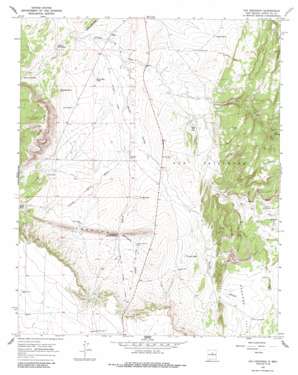
Ojo Hedionda Topo Map New Mexico
To zoom in, hover over the map of Ojo Hedionda
USGS Topo Quad 35105c8 - 1:24,000 scale
| Topo Map Name: | Ojo Hedionda |
| USGS Topo Quad ID: | 35105c8 |
| Print Size: | ca. 21 1/4" wide x 27" high |
| Southeast Coordinates: | 35.25° N latitude / 105.875° W longitude |
| Map Center Coordinates: | 35.3125° N latitude / 105.9375° W longitude |
| U.S. State: | NM |
| Filename: | o35105c8.jpg |
| Download Map JPG Image: | Ojo Hedionda topo map 1:24,000 scale |
| Map Type: | Topographic |
| Topo Series: | 7.5´ |
| Map Scale: | 1:24,000 |
| Source of Map Images: | United States Geological Survey (USGS) |
| Alternate Map Versions: |
Ojo Hedionda NM 1966, updated 1970 Download PDF Buy paper map Ojo Hedionda NM 1966, updated 1986 Download PDF Buy paper map Ojo Hedionda NM 2010 Download PDF Buy paper map Ojo Hedionda NM 2013 Download PDF Buy paper map Ojo Hedionda NM 2017 Download PDF Buy paper map |
1:24,000 Topo Quads surrounding Ojo Hedionda
> Back to 35105a1 at 1:100,000 scale
> Back to 35104a1 at 1:250,000 scale
> Back to U.S. Topo Maps home
Ojo Hedionda topo map: Gazetteer
Ojo Hedionda: Areas
Redondo Valle elevation 1941m 6368′Ojo Hedionda: Cliffs
White Bluffs elevation 2003m 6571′Ojo Hedionda: Gaps
Puertacito de los Salado elevation 1903m 6243′Ojo Hedionda: Pillars
Chapatalito elevation 1911m 6269′Ojo Hedionda: Populated Places
Chapatalito (historical) elevation 1911m 6269′Ojo Hedionda: Reservoirs
Cerro Tank elevation 1873m 6145′Coyote Tank elevation 1873m 6145′
Horse Shoe Tank elevation 1845m 6053′
La Jara Tank elevation 1915m 6282′
Lower Rock Tank elevation 1825m 5987′
Upper Rock Tank elevation 1866m 6122′
Ojo Hedionda: Ridges
Creston elevation 1980m 6496′Ojo Hedionda: Springs
Hub Spring elevation 1976m 6482′Ojo Hedionda elevation 1884m 6181′
Ojo Hedionda: Streams
Arroyo Puertacito de los Salado elevation 1851m 6072′Cañada de Medio elevation 1847m 6059′
Gaviso Arroyo elevation 1823m 5980′
Ojo Hedionda: Summits
Cerro Pelon elevation 2110m 6922′Ojo Hedionda: Valleys
Arroyo Jara elevation 1880m 6167′Hub Canyon elevation 1880m 6167′
Ojo Hedionda: Wells
10084 Water Well elevation 1864m 6115′Anaya 2 Water Well elevation 1900m 6233′
Coyote Well elevation 1864m 6115′
Hub Well elevation 1981m 6499′
La Jaca Well Number 1 elevation 1956m 6417′
La Jara HB water Well elevation 1918m 6292′
La Jara Hogback Well elevation 1916m 6286′
La Jara Well elevation 1931m 6335′
La Jara Well Number 2 elevation 1995m 6545′
La Jara Well Number 3 elevation 2037m 6683′
Mckee A Water Well elevation 1833m 6013′
Oxnard Well elevation 2007m 6584′
RG-31969 Water Well elevation 1837m 6026′
Stubby Water Well elevation 1891m 6204′
Stubby Well elevation 1893m 6210′
Virginia Piña Well elevation 1913m 6276′
West Largoeta Well elevation 1947m 6387′
Ojo Hedionda digital topo map on disk
Buy this Ojo Hedionda topo map showing relief, roads, GPS coordinates and other geographical features, as a high-resolution digital map file on DVD:


