Williams North Topo Map Arizona
To zoom in, hover over the map of Williams North
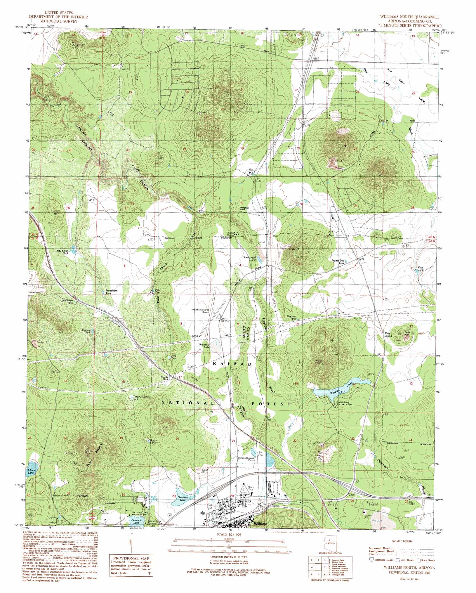
USGS Topo Quad 35112c2 - 1:24,000 scale
| Topo Map Name: | Williams North |
| USGS Topo Quad ID: | 35112c2 |
| Print Size: | ca. 21 1/4" wide x 27" high |
| Southeast Coordinates: | 35.25° N latitude / 112.125° W longitude |
| Map Center Coordinates: | 35.3125° N latitude / 112.1875° W longitude |
| U.S. State: | AZ |
| Filename: | o35112c2.jpg |
| Download Map JPG Image: | Williams North topo map 1:24,000 scale |
| Map Type: | Topographic |
| Topo Series: | 7.5´ |
| Map Scale: | 1:24,000 |
| Source of Map Images: | United States Geological Survey (USGS) |
| Alternate Map Versions: |
Williams North AZ 1989, updated 1990 Download PDF Buy paper map Williams North AZ 1989, updated 1990 Download PDF Buy paper map Williams North AZ 2012 Download PDF Buy paper map Williams North AZ 2014 Download PDF Buy paper map |
| FStopo: | US Forest Service topo Williams North is available: Download FStopo PDF Download FStopo TIF |
1:24,000 Topo Quads surrounding Williams North
Red Hill Ranch |
Mixon Tank |
Howard Lake |
Hobble Tank |
Ebert Mountain |
Stanford Tank |
Cataract Tank |
Howard Mesa |
Squaw Mountain |
Moritz Ridge |
Fitzgerald Hill |
Hearst Mountain |
Williams North |
Sitgreaves Mountain |
Parks |
Ash Fork |
Mclellan Reservoir |
Williams South |
Davenport Hill |
Garland Prairie |
Meath Spring |
Matterhorn |
May Tank Pocket |
White Horse Lake |
Sycamore Point |
> Back to 35112a1 at 1:100,000 scale
> Back to 35112a1 at 1:250,000 scale
> Back to U.S. Topo Maps home
Williams North topo map: Gazetteer
Williams North: Airports
H A Clark Memorial Field elevation 2035m 6676′Williams Municipal Airport elevation 2035m 6676′
Williams North: Crossings
Atchison Topeka and Santa Fe Underpass elevation 2081m 6827′Williams Overpass (historical) elevation 2081m 6827′
Williams North: Dams
Kaibab Dam elevation 2072m 6797′West Cataract Creek Dam elevation 2067m 6781′
Williams North: Forests
Williams Ranger District elevation 2115m 6938′Williams North: Lakes
Cataract Lake elevation 2077m 6814′Gonzalez Lake elevation 2057m 6748′
Holden Lake elevation 2135m 7004′
Smith Lake elevation 1965m 6446′
Threemile Lake elevation 2035m 6676′
Williams North: Parks
Williams Little League Park and Municipal Swimming Pool elevation 2056m 6745′Williams North: Reservoirs
Canyon Tank elevation 2023m 6637′Dirty Smith Tank elevation 1970m 6463′
DT Tank elevation 2092m 6863′
Fues Tank elevation 2036m 6679′
Kaibab Lake elevation 2072m 6797′
Muleshoe Tank elevation 1993m 6538′
Pen Tank elevation 1980m 6496′
Pine Tank elevation 2012m 6601′
Pipeline Tank elevation 2049m 6722′
Pit Tank elevation 2079m 6820′
Pitt Tank elevation 2007m 6584′
Prairie Dog Tank elevation 2037m 6683′
Pronghorn Tank elevation 1999m 6558′
Red Tank elevation 1990m 6528′
Smith Tank elevation 2096m 6876′
Sweetwood Tank elevation 1991m 6532′
Three Sisters Tank elevation 2094m 6870′
Topeka Tank elevation 2037m 6683′
Williams North: Springs
Fues Spring elevation 2078m 6817′Williams North: Streams
Dogtown Wash elevation 1995m 6545′Pine Creek Wash elevation 1964m 6443′
Williams North: Summits
Fues Hill elevation 2139m 7017′Three Sisters elevation 2320m 7611′
Williams North: Valleys
Red Lake Valley elevation 1981m 6499′Williams North digital topo map on disk
Buy this Williams North topo map showing relief, roads, GPS coordinates and other geographical features, as a high-resolution digital map file on DVD: