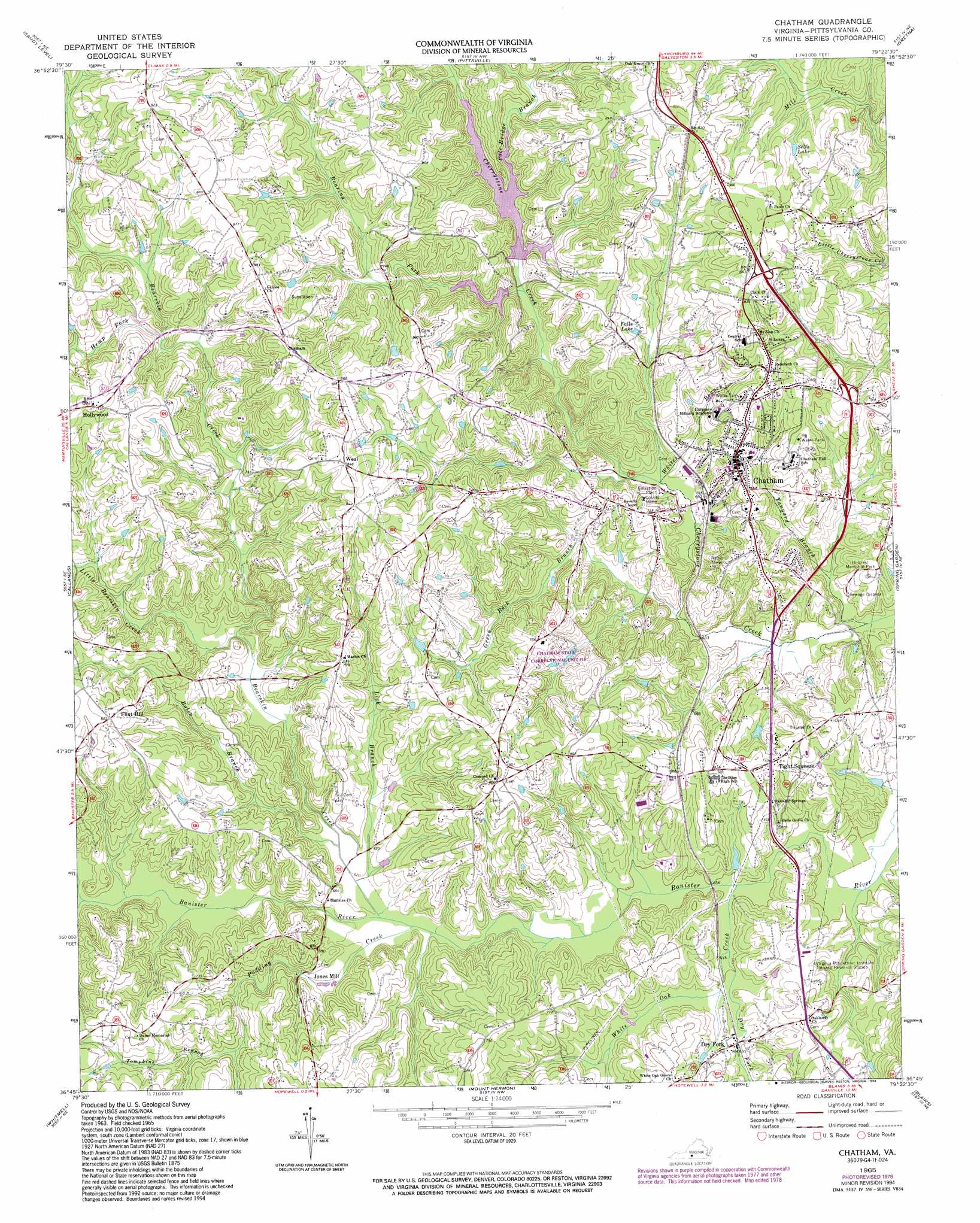
Chatham Topo Map Virginia
To zoom in, hover over the map of Chatham
USGS Topo Quad 36079g4 - 1:24,000 scale
| Topo Map Name: | Chatham |
| USGS Topo Quad ID: | 36079g4 |
| Print Size: | ca. 21 1/4" wide x 27" high |
| Southeast Coordinates: | 36.75° N latitude / 79.375° W longitude |
| Map Center Coordinates: | 36.8125° N latitude / 79.4375° W longitude |
| U.S. State: | VA |
| Filename: | o36079g4.jpg |
| Download Map JPG Image: | Chatham topo map 1:24,000 scale |
| Map Type: | Topographic |
| Topo Series: | 7.5´ |
| Map Scale: | 1:24,000 |
| Source of Map Images: | United States Geological Survey (USGS) |
| Alternate Map Versions: |
Chatham VA 1965, updated 1968 Download PDF Buy paper map Chatham VA 1965, updated 1978 Download PDF Buy paper map Chatham VA 1965, updated 1994 Download PDF Buy paper map Chatham VA 2011 Download PDF Buy paper map Chatham VA 2013 Download PDF Buy paper map Chatham VA 2016 Download PDF Buy paper map |
1:24,000 Topo Quads surrounding Chatham
Moneta Sw |
Smith Mountain Dam |
Leesville |
Altavista |
Straightstone |
Penhook |
Sandy Level |
Pittsville |
Gretna |
Mount Airy |
Mountain Valley |
Callands |
Chatham |
Spring Garden |
Java |
Axton |
Whitmell |
Mount Hermon |
Blairs |
Ingram |
Northeast Eden |
Brosville |
Danville |
Ringgold |
Milton |
> Back to 36079e1 at 1:100,000 scale
> Back to 36078a1 at 1:250,000 scale
> Back to U.S. Topo Maps home
Chatham topo map: Gazetteer
Chatham: Airports
Jefferson-Watson Airport elevation 238m 780′Chatham: Bridges
Rawley White Martin Memorial Bridge elevation 181m 593′Chatham: Dams
Adams Dam elevation 202m 662′Cherrystone Number 2a Dam elevation 216m 708′
Cherrystone Number One Dam elevation 216m 708′
Giles Dam elevation 213m 698′
Kendall Dam elevation 196m 643′
Whitehead Dam elevation 183m 600′
Chatham: Populated Places
Beverly Heights elevation 212m 695′Chatham elevation 222m 728′
Dry Fork elevation 189m 620′
Eldon Knolls elevation 225m 738′
Flint Hill elevation 252m 826′
Gilmer Terrace elevation 228m 748′
Halifax Hills elevation 212m 695′
Hollywood elevation 270m 885′
Jones Mill elevation 191m 626′
Oakland elevation 221m 725′
Weal elevation 262m 859′
Whittletown elevation 207m 679′
Woodlawn elevation 218m 715′
Woodlawn Heights elevation 232m 761′
Chatham: Post Offices
Chatham Post Office elevation 220m 721′Chatham: Reservoirs
Falls Lake elevation 218m 715′Selfs Lake elevation 233m 764′
Chatham: Streams
Bearskin Creek elevation 187m 613′Bolin Branch elevation 189m 620′
Dry Fork elevation 180m 590′
Green Rock Branch elevation 182m 597′
Hemp Fork elevation 218m 715′
Lick Branch elevation 188m 616′
Little Bearskin Creek elevation 205m 672′
Pole Bridge Branch elevation 198m 649′
Pudding Creek elevation 189m 620′
Roaring Fork elevation 195m 639′
Strawberry Creek elevation 192m 629′
Tanyard Branch elevation 175m 574′
Tompkins Branch elevation 207m 679′
White Oak Creek elevation 180m 590′
Whites Branch elevation 185m 606′
Chatham digital topo map on disk
Buy this Chatham topo map showing relief, roads, GPS coordinates and other geographical features, as a high-resolution digital map file on DVD:
Western Virginia & Southern West Virginia
Buy digital topo maps: Western Virginia & Southern West Virginia