Mountain Valley Topo Map Virginia
To zoom in, hover over the map of Mountain Valley
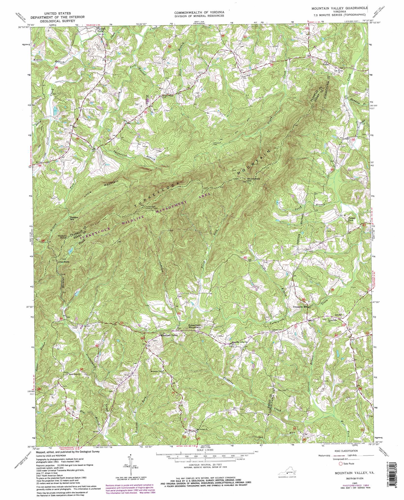
USGS Topo Quad 36079g6 - 1:24,000 scale
| Topo Map Name: | Mountain Valley |
| USGS Topo Quad ID: | 36079g6 |
| Print Size: | ca. 21 1/4" wide x 27" high |
| Southeast Coordinates: | 36.75° N latitude / 79.625° W longitude |
| Map Center Coordinates: | 36.8125° N latitude / 79.6875° W longitude |
| U.S. State: | VA |
| Filename: | o36079g6.jpg |
| Download Map JPG Image: | Mountain Valley topo map 1:24,000 scale |
| Map Type: | Topographic |
| Topo Series: | 7.5´ |
| Map Scale: | 1:24,000 |
| Source of Map Images: | United States Geological Survey (USGS) |
| Alternate Map Versions: |
Mountain Valley VA 1965, updated 1967 Download PDF Buy paper map Mountain Valley VA 1965, updated 1984 Download PDF Buy paper map Mountain Valley VA 1965, updated 1984 Download PDF Buy paper map Mountain Valley VA 2011 Download PDF Buy paper map Mountain Valley VA 2013 Download PDF Buy paper map Mountain Valley VA 2016 Download PDF Buy paper map |
1:24,000 Topo Quads surrounding Mountain Valley
Boones Mill |
Redwood |
Moneta Sw |
Smith Mountain Dam |
Leesville |
Rocky Mount |
Gladehill |
Penhook |
Sandy Level |
Pittsville |
Bassett |
Snow Creek |
Mountain Valley |
Callands |
Chatham |
Martinsville West |
Martinsville East |
Axton |
Whitmell |
Mount Hermon |
Price |
Northwest Eden |
Northeast Eden |
Brosville |
Danville |
> Back to 36079e1 at 1:100,000 scale
> Back to 36078a1 at 1:250,000 scale
> Back to U.S. Topo Maps home
Mountain Valley topo map: Gazetteer
Mountain Valley: Gaps
Double Oaks Gap elevation 434m 1423′Mountain Valley: Parks
Turkeycock Wildlife Management Area elevation 475m 1558′Mountain Valley: Populated Places
Grady elevation 280m 918′Swansons Mill elevation 260m 853′
Turkey Fork elevation 251m 823′
Vashti elevation 258m 846′
Mountain Valley: Streams
Crab Creek elevation 249m 816′Elm Branch elevation 251m 823′
Flippins Creek elevation 216m 708′
Garrett Branch elevation 216m 708′
Grassy Fork elevation 234m 767′
Guthrie Branch elevation 242m 793′
Hundley Branch elevation 225m 738′
James Branch elevation 262m 859′
Keaton Branch elevation 243m 797′
Machine Creek elevation 289m 948′
North Fork Turkeycock Creek elevation 281m 921′
Polecat Branch elevation 241m 790′
Sailor Creek elevation 225m 738′
Swiftwater Branch elevation 254m 833′
Terry Branch elevation 237m 777′
Mountain Valley: Summits
Hickory Knob elevation 423m 1387′Little Mountain elevation 391m 1282′
Robertson Mountain elevation 347m 1138′
Turkeycock Mountain elevation 507m 1663′
Mountain Valley digital topo map on disk
Buy this Mountain Valley topo map showing relief, roads, GPS coordinates and other geographical features, as a high-resolution digital map file on DVD:
Western Virginia & Southern West Virginia
Buy digital topo maps: Western Virginia & Southern West Virginia