Zinc Topo Map Arkansas
To zoom in, hover over the map of Zinc
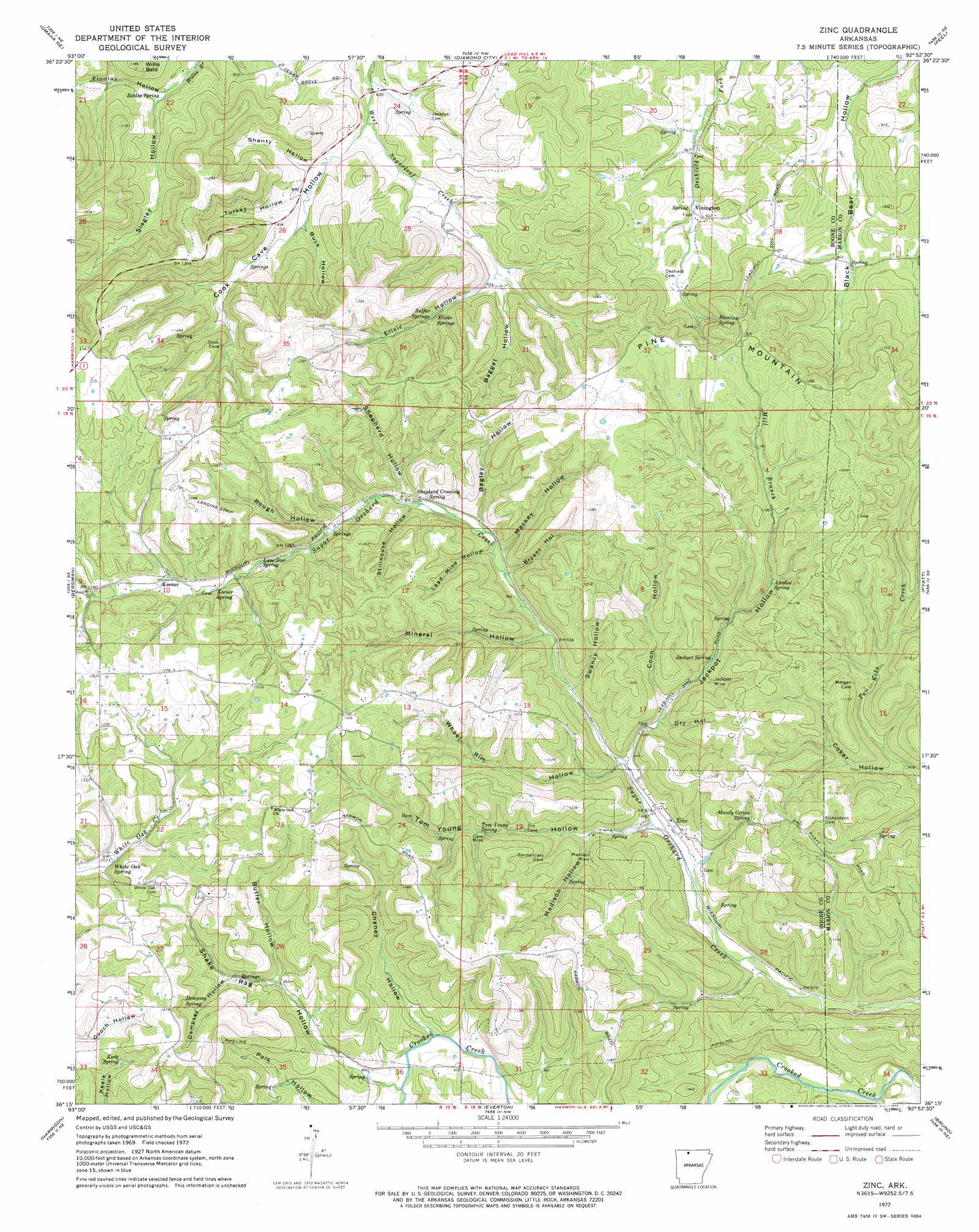
USGS Topo Quad 36092c8 - 1:24,000 scale
| Topo Map Name: | Zinc |
| USGS Topo Quad ID: | 36092c8 |
| Print Size: | ca. 21 1/4" wide x 27" high |
| Southeast Coordinates: | 36.25° N latitude / 92.875° W longitude |
| Map Center Coordinates: | 36.3125° N latitude / 92.9375° W longitude |
| U.S. State: | AR |
| Filename: | o36092c8.jpg |
| Download Map JPG Image: | Zinc topo map 1:24,000 scale |
| Map Type: | Topographic |
| Topo Series: | 7.5´ |
| Map Scale: | 1:24,000 |
| Source of Map Images: | United States Geological Survey (USGS) |
| Alternate Map Versions: |
Zinc AR 1972, updated 1973 Download PDF Buy paper map Zinc AR 2011 Download PDF Buy paper map Zinc AR 2014 Download PDF Buy paper map |
1:24,000 Topo Quads surrounding Zinc
Hollister |
Mincy |
Protem Sw |
Protem |
Theodosia |
Omaha |
Omaha Ne |
Diamond City |
Peel |
Cotter Nw |
Batavia |
Bergman |
Zinc |
Pyatt |
Cotter Sw |
Gaither |
Harrison |
Everton |
Bruno |
Yellville |
Jasper |
Hasty |
Western Grove |
Saint Joe |
Maumee |
> Back to 36092a1 at 1:100,000 scale
> Back to 36092a1 at 1:250,000 scale
> Back to U.S. Topo Maps home
Zinc topo map: Gazetteer
Zinc: Mines
Jackpot Mine elevation 312m 1023′Madison Mine elevation 299m 980′
Zinc: Populated Places
Keener elevation 341m 1118′Winington elevation 272m 892′
Zinc elevation 264m 866′
Zinc: Springs
Alcohol Spring elevation 313m 1026′Belden Spring elevation 260m 853′
Blowing Spring elevation 350m 1148′
Dempsey Spring elevation 344m 1128′
Elixir Springs elevation 302m 990′
Jackpot Spring elevation 288m 944′
Keele Spring elevation 330m 1082′
Keener Spring elevation 348m 1141′
Lone Star Spring elevation 324m 1062′
Mandy Cotton Spring elevation 309m 1013′
Shepherd Crossing Spring elevation 303m 994′
Sulfur Springs elevation 313m 1026′
Tom Young Spring elevation 309m 1013′
White Oak Spring elevation 321m 1053′
Zinc: Streams
Mill Branch elevation 265m 869′Zinc: Summits
Pilot Knob elevation 373m 1223′Pine Mountain elevation 397m 1302′
Willis Bald elevation 360m 1181′
Zinc: Valleys
Bagget Hollow elevation 282m 925′Bagley Hollow elevation 291m 954′
Bryant Hollow elevation 285m 935′
Buck Hollow elevation 270m 885′
Butler Hollow elevation 290m 951′
Chaney Hollow elevation 250m 820′
Coker Hollow elevation 254m 833′
Cook Cave Hollow elevation 248m 813′
Coon Hollow elevation 277m 908′
Dempsey Hollow elevation 304m 997′
Elixir Hollow elevation 282m 925′
Findlay Hollow elevation 260m 853′
Jackpot Hollow elevation 266m 872′
Lead Mine Hollow elevation 293m 961′
Mackey Hollow elevation 287m 941′
Madison Hollow elevation 275m 902′
Mineral Hollow elevation 281m 921′
Rough Hollow elevation 313m 1026′
Shake Rag Hollow elevation 256m 839′
Shanty Hollow elevation 258m 846′
Shepherd Hollow elevation 303m 994′
Slagley Hollow elevation 262m 859′
Stillhouse Hollow elevation 299m 980′
Swancy Hollow elevation 274m 898′
Tom Young Hollow elevation 261m 856′
Turkey Hollow elevation 265m 869′
Wheel Rim Hollow elevation 269m 882′
Zinc digital topo map on disk
Buy this Zinc topo map showing relief, roads, GPS coordinates and other geographical features, as a high-resolution digital map file on DVD: