Charleston Peak Topo Map Nevada
To zoom in, hover over the map of Charleston Peak
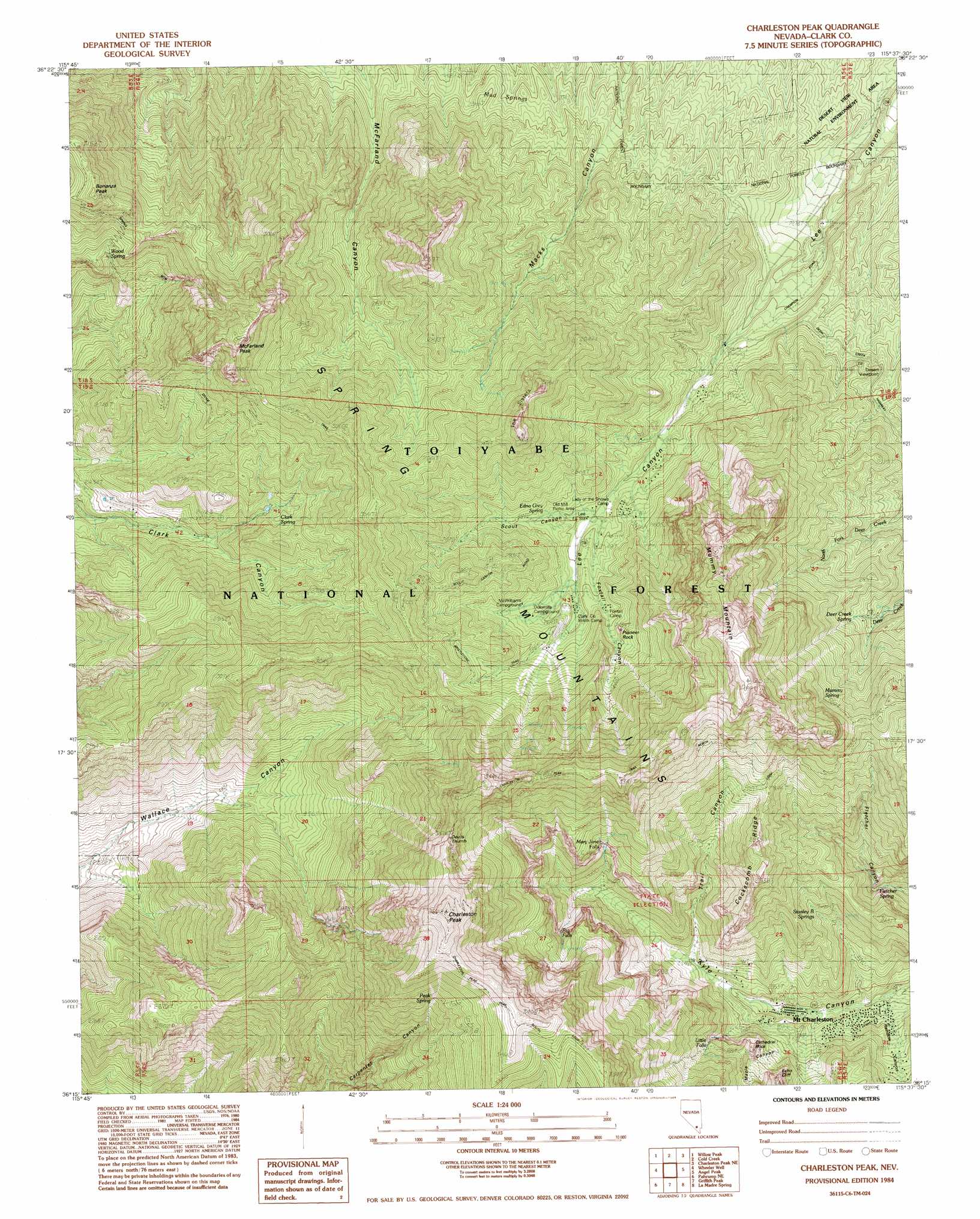
USGS Topo Quad 36115c6 - 1:24,000 scale
| Topo Map Name: | Charleston Peak |
| USGS Topo Quad ID: | 36115c6 |
| Print Size: | ca. 21 1/4" wide x 27" high |
| Southeast Coordinates: | 36.25° N latitude / 115.625° W longitude |
| Map Center Coordinates: | 36.3125° N latitude / 115.6875° W longitude |
| U.S. State: | NV |
| Filename: | o36115c6.jpg |
| Download Map JPG Image: | Charleston Peak topo map 1:24,000 scale |
| Map Type: | Topographic |
| Topo Series: | 7.5´ |
| Map Scale: | 1:24,000 |
| Source of Map Images: | United States Geological Survey (USGS) |
| Alternate Map Versions: |
Charleston Peak NV 1984, updated 1984 Download PDF Buy paper map Charleston Peak NV 2012 Download PDF Buy paper map Charleston Peak NV 2014 Download PDF Buy paper map |
| FStopo: | US Forest Service topo Charleston Peak is available: Download FStopo PDF Download FStopo TIF |
1:24,000 Topo Quads surrounding Charleston Peak
Niavi Wash |
Mercury Se |
Indian Springs |
Indian Springs Se |
Black Hills Sw |
Mount Stirling |
Willow Peak |
Cold Creek |
Charleston Peak Ne |
Corn Creek Springs Nw |
Horse Springs |
Wheeler Well |
Charleston Peak |
Angel Peak |
Grapevine Spring |
Pahrump |
Pahrump Ne |
Griffith Peak |
La Madre Spring |
La Madre Mountain |
Mound Spring |
Hidden Hills Ranch |
Lost Cabin Spring |
Mountain Springs |
Blue Diamond |
> Back to 36115a1 at 1:100,000 scale
> Back to 36114a1 at 1:250,000 scale
> Back to U.S. Topo Maps home
Charleston Peak topo map: Gazetteer
Charleston Peak: Cliffs
Echo Cliff elevation 2534m 8313′Charleston Peak: Falls
Big Falls elevation 2727m 8946′Little Falls elevation 2558m 8392′
Mary Jane Falls elevation 2723m 8933′
Charleston Peak: Forests
Las Vegas Ranger District elevation 2612m 8569′Charleston Peak: Mines
Ada and Edith Mine elevation 2541m 8336′Griffith Mine elevation 2446m 8024′
Charleston Peak: Pillars
Cathedral Rock elevation 2518m 8261′Devils Thumb elevation 3358m 11017′
Pioneer Rock elevation 2730m 8956′
Charleston Peak: Populated Places
Kyle Canyon Summer Home Area elevation 2329m 7641′Lee Canyon Summer Home Area elevation 2564m 8412′
Mount Charleston elevation 2288m 7506′
Charleston Peak: Post Offices
Alpine Village Rural Branch Post Office (historical) elevation 2193m 7194′Charleston Peak: Ridges
Cockscomb Ridge elevation 2814m 9232′Charleston Peak: Springs
Cave Spring elevation 3026m 9927′Clark Spring elevation 2648m 8687′
Deer Creek Spring elevation 2646m 8681′
Edna Grey Spring elevation 2593m 8507′
Fletcher Spring elevation 2341m 7680′
McWilliams Spring elevation 2640m 8661′
Mud Springs elevation 2282m 7486′
Mummy Spring elevation 3000m 9842′
Peak Spring elevation 3156m 10354′
Scout Canyon Spring elevation 2599m 8526′
Stanley B Springs elevation 2522m 8274′
Three Springs elevation 2993m 9819′
Wood Spring elevation 2751m 9025′
Charleston Peak: Summits
Bonanza Peak elevation 3164m 10380′Charleston Peak elevation 3600m 11811′
McFarland Peak elevation 3267m 10718′
Mummy Mountain elevation 3443m 11295′
The Sisters elevation 3093m 10147′
Charleston Peak: Trails
Bristlecone Trail elevation 2747m 9012′Cathedral Rock Trail elevation 2441m 8008′
Charleston Peak Trail North Loop elevation 3276m 10748′
Deer Creek Trail elevation 2879m 9445′
Falls Trail elevation 2471m 8106′
Mount Charleston National Recreation Trail elevation 2418m 7933′
South Loop elevation 3447m 11309′
Spring Mountain Divide Trail elevation 2732m 8963′
Charleston Peak: Valleys
Foxtail Canyon elevation 2518m 8261′Mazie Canyon elevation 2312m 7585′
Rainbow Canyon elevation 2214m 7263′
Scout Canyon elevation 2539m 8330′
Trail Canyon elevation 2357m 7732′
Charleston Peak digital topo map on disk
Buy this Charleston Peak topo map showing relief, roads, GPS coordinates and other geographical features, as a high-resolution digital map file on DVD:
Southern Sierra Nevada, California & Southern Nevada
Buy digital topo maps: Southern Sierra Nevada, California & Southern Nevada