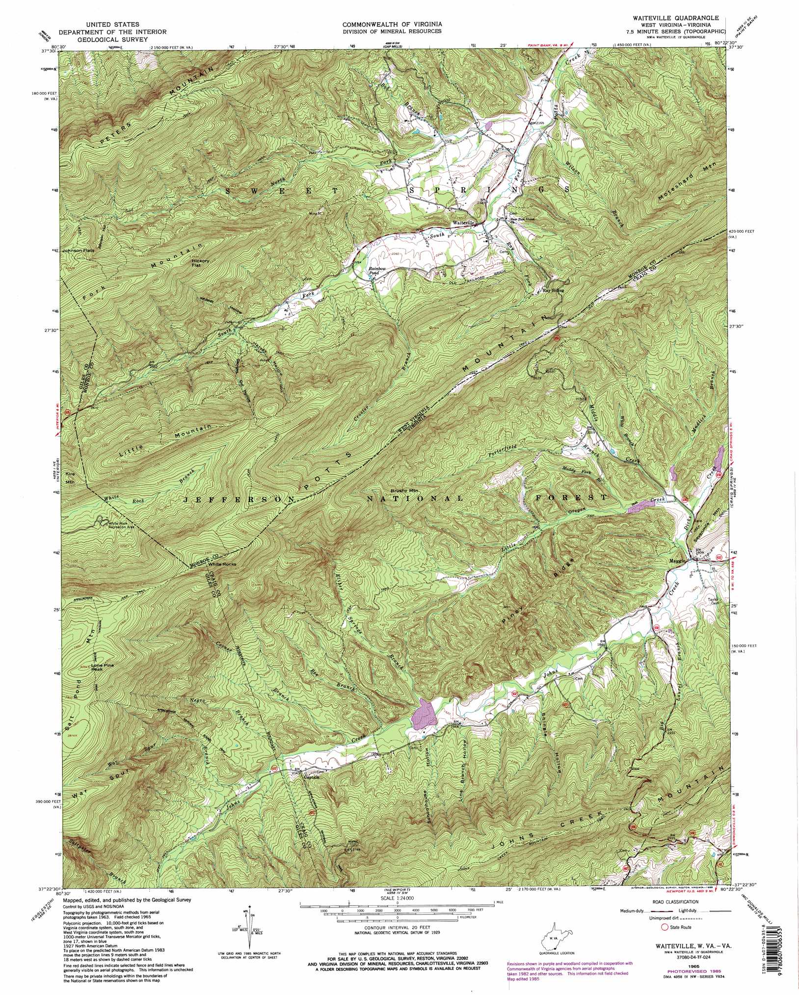
Waiteville Topo Map Virginia
To zoom in, hover over the map of Waiteville
USGS Topo Quad 37080d4 - 1:24,000 scale
| Topo Map Name: | Waiteville |
| USGS Topo Quad ID: | 37080d4 |
| Print Size: | ca. 21 1/4" wide x 27" high |
| Southeast Coordinates: | 37.375° N latitude / 80.375° W longitude |
| Map Center Coordinates: | 37.4375° N latitude / 80.4375° W longitude |
| U.S. States: | VA, WV |
| Filename: | o37080d4.jpg |
| Download Map JPG Image: | Waiteville topo map 1:24,000 scale |
| Map Type: | Topographic |
| Topo Series: | 7.5´ |
| Map Scale: | 1:24,000 |
| Source of Map Images: | United States Geological Survey (USGS) |
| Alternate Map Versions: |
Waiteville WV 1965, updated 1967 Download PDF Buy paper map Waiteville WV 1965, updated 1986 Download PDF Buy paper map Waiteville WV 1998, updated 2001 Download PDF Buy paper map Waiteville WV 2011 Download PDF Buy paper map Waiteville WV 2014 Download PDF Buy paper map Waiteville WV 2016 Download PDF Buy paper map |
| FStopo: | US Forest Service topo Waiteville is available: Download FStopo PDF Download FStopo TIF |
1:24,000 Topo Quads surrounding Waiteville
Alderson |
Fort Spring |
Ronceverte |
Glace |
Alleghany |
Greenville |
Union |
Gap Mills |
Paint Bank |
Potts Creek |
Lindside |
Interior |
Waiteville |
Craig Springs |
Looney |
Pearisburg |
Eggleston |
Newport |
Mcdonalds Mill |
Glenvar |
Staffordsville |
Radford North |
Blacksburg |
Ironto |
Elliston |
> Back to 37080a1 at 1:100,000 scale
> Back to 37080a1 at 1:250,000 scale
> Back to U.S. Topo Maps home
Waiteville topo map: Gazetteer
Waiteville: Dams
Johns Creek Number Four Dam elevation 566m 1856′Johns Creek Number One Dam elevation 585m 1919′
Johns Creek Number Three Dam elevation 564m 1850′
Johns Creek Number Two Dam elevation 563m 1847′
Waiteville: Flats
Johnson Flats elevation 1050m 3444′Waiteville: Forests
Jefferson National Forest elevation 685m 2247′Waiteville: Gaps
Hickory Flat elevation 1100m 3608′Waiteville: Lakes
Rainbow Pond elevation 692m 2270′Waiteville: Parks
Potts Creek Wildlife Management Area elevation 690m 2263′White Rock Recreation Area elevation 920m 3018′
Waiteville: Pillars
White Rocks elevation 1201m 3940′Waiteville: Populated Places
Captain elevation 621m 2037′Maggie elevation 549m 1801′
Waiteville elevation 669m 2194′
Waiteville: Post Offices
Waiteville Post Office elevation 669m 2194′Waiteville: Ranges
Potts Mountain elevation 969m 3179′Waiteville: Reservoirs
Connallys Lake elevation 566m 1856′McDaniels Lake elevation 585m 1919′
Waiteville: Ridges
Piney Ridge elevation 615m 2017′War Spur elevation 1105m 3625′
Waiteville: Springs
Jimmy Horry Spring elevation 696m 2283′Waiteville: Streams
Bee Branch elevation 590m 1935′Big Laurel Branch elevation 553m 1814′
Bob Branch elevation 677m 2221′
Corner Branch elevation 596m 1955′
Crosier Branch elevation 682m 2237′
Dicks Creek elevation 549m 1801′
Eliber Springs Branch elevation 588m 1929′
Little Oregon Creek elevation 554m 1817′
Middle Creek elevation 555m 1820′
Muddy Fork Branch elevation 571m 1873′
Mudlick Branch elevation 554m 1817′
Negro Branch elevation 608m 1994′
North Fork Potts Creek elevation 659m 2162′
Porterfield Branch elevation 561m 1840′
Ray Fork elevation 666m 2185′
Saltpeter Branch elevation 677m 2221′
South Fork Potts Creek elevation 659m 2162′
War Spur Branch elevation 615m 2017′
White Branch elevation 570m 1870′
Wilson Branch elevation 659m 2162′
Waiteville: Summits
Brushy Mountain elevation 869m 2851′Fork Mountain elevation 1190m 3904′
Fork Mountain elevation 1192m 3910′
Kire Mountain elevation 1034m 3392′
Little Mountain elevation 1127m 3697′
Lone Pine Peak elevation 1232m 4041′
Salt Pond Mountain elevation 1231m 4038′
Waiteville: Trails
Johns Creek Mountain Trail elevation 1018m 3339′Virginias Walk Trail elevation 896m 2939′
Virginias Walk Trail elevation 896m 2939′
War Spur Connector elevation 1160m 3805′
War Spur Trail elevation 1107m 3631′
Waiteville: Valleys
Georges Cut Hollow elevation 757m 2483′Harvey Hollow elevation 741m 2431′
Johnson Hollow elevation 958m 3143′
Line Branch Hollow elevation 577m 1893′
Schoolhouse Hollow elevation 587m 1925′
Shingle Hollow elevation 572m 1876′
Whiskey Hollow elevation 729m 2391′
Waiteville digital topo map on disk
Buy this Waiteville topo map showing relief, roads, GPS coordinates and other geographical features, as a high-resolution digital map file on DVD:
Western Virginia & Southern West Virginia
Buy digital topo maps: Western Virginia & Southern West Virginia