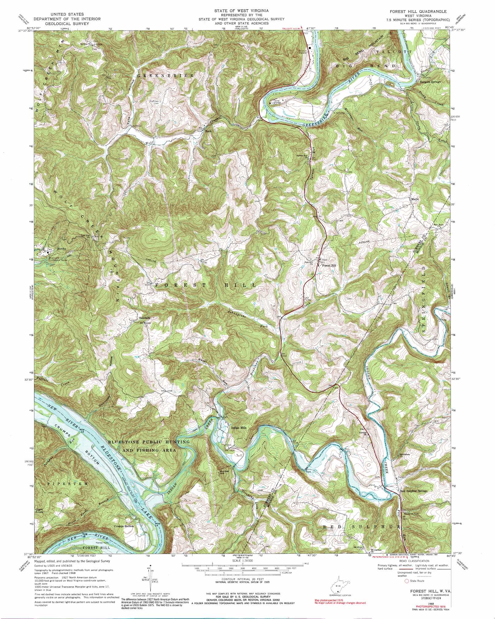
Forest Hill Topo Map West Virginia
To zoom in, hover over the map of Forest Hill
USGS Topo Quad 37080e7 - 1:24,000 scale
| Topo Map Name: | Forest Hill |
| USGS Topo Quad ID: | 37080e7 |
| Print Size: | ca. 21 1/4" wide x 27" high |
| Southeast Coordinates: | 37.5° N latitude / 80.75° W longitude |
| Map Center Coordinates: | 37.5625° N latitude / 80.8125° W longitude |
| U.S. State: | WV |
| Filename: | o37080e7.jpg |
| Download Map JPG Image: | Forest Hill topo map 1:24,000 scale |
| Map Type: | Topographic |
| Topo Series: | 7.5´ |
| Map Scale: | 1:24,000 |
| Source of Map Images: | United States Geological Survey (USGS) |
| Alternate Map Versions: |
Forest Hill WV 1968, updated 1971 Download PDF Buy paper map Forest Hill WV 1968, updated 1991 Download PDF Buy paper map Forest Hill WV 2011 Download PDF Buy paper map Forest Hill WV 2014 Download PDF Buy paper map Forest Hill WV 2016 Download PDF Buy paper map |
1:24,000 Topo Quads surrounding Forest Hill
Prince |
Meadow Creek |
Meadow Bridge |
Dawson |
Asbury |
Shady Spring |
Hinton |
Talcott |
Alderson |
Fort Spring |
Flat Top |
Pipestem |
Forest Hill |
Greenville |
Union |
Athens |
Lerona |
Peterstown |
Lindside |
Interior |
Princeton |
Oakvale |
Narrows |
Pearisburg |
Eggleston |
> Back to 37080e1 at 1:100,000 scale
> Back to 37080a1 at 1:250,000 scale
> Back to U.S. Topo Maps home
Forest Hill topo map: Gazetteer
Forest Hill: Bends
Crumps Bottom elevation 437m 1433′Forest Hill: Falls
Harvey Falls elevation 434m 1423′Forest Hill: Populated Places
Bargers Springs elevation 453m 1486′Bertha elevation 506m 1660′
Buck elevation 501m 1643′
Crumps Bottom elevation 455m 1492′
Forest Hill elevation 587m 1925′
Indian Mills elevation 472m 1548′
Junta (historical) elevation 460m 1509′
Marie elevation 629m 2063′
Seminole elevation 678m 2224′
Forest Hill: Post Offices
Forest Hill Post Office elevation 588m 1929′Indian Mills Post Office elevation 469m 1538′
Forest Hill: Springs
Bargers Spring elevation 445m 1459′Red Sulphur Spring elevation 484m 1587′
Forest Hill: Streams
Blue Lick elevation 443m 1453′Bradshaw Creek elevation 450m 1476′
Fitz Run elevation 466m 1528′
Horse Fork Branch elevation 436m 1430′
Indian Creek elevation 433m 1420′
Johnnycake Fork elevation 491m 1610′
Joshuas Run elevation 433m 1420′
Kissinger Run elevation 434m 1423′
Little Stony Creek elevation 441m 1446′
Lowell Branch elevation 472m 1548′
Spruce Run elevation 445m 1459′
Stinking Lick Creek elevation 453m 1486′
Stony Creek elevation 441m 1446′
Wheel Run elevation 467m 1532′
Wolf Creek elevation 434m 1423′
Forest Hill: Summits
Bunker Hill elevation 650m 2132′Wolf Creek Mountain elevation 871m 2857′
Forest Hill: Valleys
Dickinson Hollow elevation 450m 1476′Kate Hollow elevation 505m 1656′
Stony Creek Gorge elevation 448m 1469′
Forest Hill digital topo map on disk
Buy this Forest Hill topo map showing relief, roads, GPS coordinates and other geographical features, as a high-resolution digital map file on DVD:
Western Virginia & Southern West Virginia
Buy digital topo maps: Western Virginia & Southern West Virginia