Dundee Topo Map Kentucky
To zoom in, hover over the map of Dundee
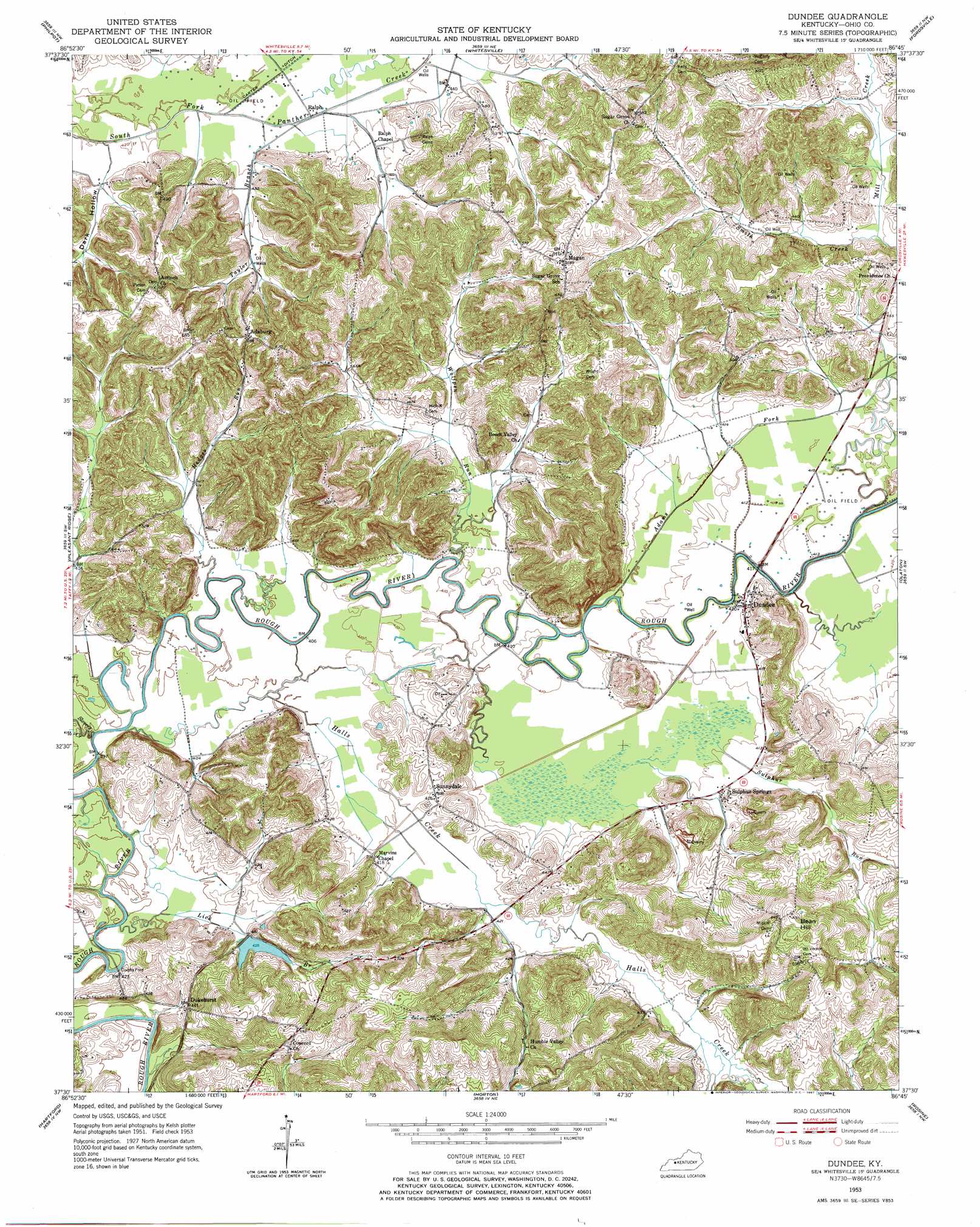
USGS Topo Quad 37086e7 - 1:24,000 scale
| Topo Map Name: | Dundee |
| USGS Topo Quad ID: | 37086e7 |
| Print Size: | ca. 21 1/4" wide x 27" high |
| Southeast Coordinates: | 37.5° N latitude / 86.75° W longitude |
| Map Center Coordinates: | 37.5625° N latitude / 86.8125° W longitude |
| U.S. State: | KY |
| Filename: | o37086e7.jpg |
| Download Map JPG Image: | Dundee topo map 1:24,000 scale |
| Map Type: | Topographic |
| Topo Series: | 7.5´ |
| Map Scale: | 1:24,000 |
| Source of Map Images: | United States Geological Survey (USGS) |
| Alternate Map Versions: |
Dundee KY 1953, updated 1954 Download PDF Buy paper map Dundee KY 1953, updated 1967 Download PDF Buy paper map Dundee KY 2010 Download PDF Buy paper map Dundee KY 2013 Download PDF Buy paper map Dundee KY 2016 Download PDF Buy paper map |
1:24,000 Topo Quads surrounding Dundee
Owensboro East |
Maceo |
Pellville |
Cloverport |
Mattingly |
Sutherland |
Philpot |
Whitesville |
Fordsville |
Glen Dean |
Utica |
Pleasant Ridge |
Dundee |
Olaton |
Falls Of Rough |
Equality |
Hartford |
Horton |
Rosine |
Spring Lick |
Central City East |
Paradise |
Cromwell |
Flener |
Welchs Creek |
> Back to 37086e1 at 1:100,000 scale
> Back to 37086a1 at 1:250,000 scale
> Back to U.S. Topo Maps home
Dundee topo map: Gazetteer
Dundee: Airports
MGT Station 2105 Heliport elevation 166m 544′Dundee: Populated Places
Adaburg elevation 183m 600′Combs Ford elevation 122m 400′
Dukehurst elevation 126m 413′
Dundee elevation 129m 423′
Magan elevation 173m 567′
Ralph elevation 127m 416′
Sulphur Springs elevation 130m 426′
Sunnydale elevation 132m 433′
Dundee: Streams
Adams Fork elevation 122m 400′Clear Run elevation 118m 387′
Halls Creek elevation 119m 390′
Hedges Run elevation 119m 390′
Lick Branch elevation 118m 387′
Mill Creek elevation 127m 416′
Slovers Creek elevation 120m 393′
Sulphur Run elevation 125m 410′
Taylor Branch elevation 128m 419′
Wolf Creek elevation 132m 433′
Wolfpen Run elevation 125m 410′
Dundee: Summits
Bean Hill elevation 207m 679′Dundee: Valleys
Dark Hollow elevation 130m 426′Dundee digital topo map on disk
Buy this Dundee topo map showing relief, roads, GPS coordinates and other geographical features, as a high-resolution digital map file on DVD: