Kingswood Topo Map Kentucky
To zoom in, hover over the map of Kingswood
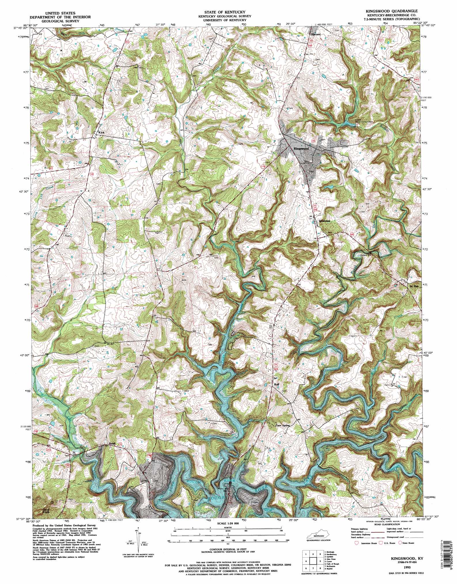
USGS Topo Quad 37086f4 - 1:24,000 scale
| Topo Map Name: | Kingswood |
| USGS Topo Quad ID: | 37086f4 |
| Print Size: | ca. 21 1/4" wide x 27" high |
| Southeast Coordinates: | 37.625° N latitude / 86.375° W longitude |
| Map Center Coordinates: | 37.6875° N latitude / 86.4375° W longitude |
| U.S. State: | KY |
| Filename: | o37086f4.jpg |
| Download Map JPG Image: | Kingswood topo map 1:24,000 scale |
| Map Type: | Topographic |
| Topo Series: | 7.5´ |
| Map Scale: | 1:24,000 |
| Source of Map Images: | United States Geological Survey (USGS) |
| Alternate Map Versions: |
Kingswood KY 1953, updated 1954 Download PDF Buy paper map Kingswood KY 1963, updated 1964 Download PDF Buy paper map Kingswood KY 1963, updated 1976 Download PDF Buy paper map Kingswood KY 1963, updated 1990 Download PDF Buy paper map Kingswood KY 1993, updated 1996 Download PDF Buy paper map Kingswood KY 2010 Download PDF Buy paper map Kingswood KY 2013 Download PDF Buy paper map Kingswood KY 2016 Download PDF Buy paper map |
1:24,000 Topo Quads surrounding Kingswood
Cannelton |
Rome |
Lodiburg |
Irvington |
Guston |
Cloverport |
Mattingly |
Hardinsburg |
Garfield |
Big Spring |
Fordsville |
Glen Dean |
Kingswood |
Custer |
Constantine |
Olaton |
Falls Of Rough |
Mcdaniels |
Madrid |
Big Clifty |
Rosine |
Spring Lick |
Caneyville |
Leitchfield |
Clarkson |
> Back to 37086e1 at 1:100,000 scale
> Back to 37086a1 at 1:250,000 scale
> Back to U.S. Topo Maps home
Kingswood topo map: Gazetteer
Kingswood: Populated Places
Axtel elevation 181m 593′Cave Spring elevation 172m 564′
Kingswood elevation 223m 731′
Kirk elevation 218m 715′
Roff elevation 209m 685′
Se Ree elevation 220m 721′
Westview elevation 226m 741′
Kingswood: Streams
Buffalo Creek elevation 158m 518′Calamese Creek elevation 150m 492′
Tuckers Branch elevation 150m 492′
Tules Creek elevation 150m 492′
White Oak Creek elevation 150m 492′
Kingswood: Summits
Sand Knob elevation 246m 807′Kingswood digital topo map on disk
Buy this Kingswood topo map showing relief, roads, GPS coordinates and other geographical features, as a high-resolution digital map file on DVD: