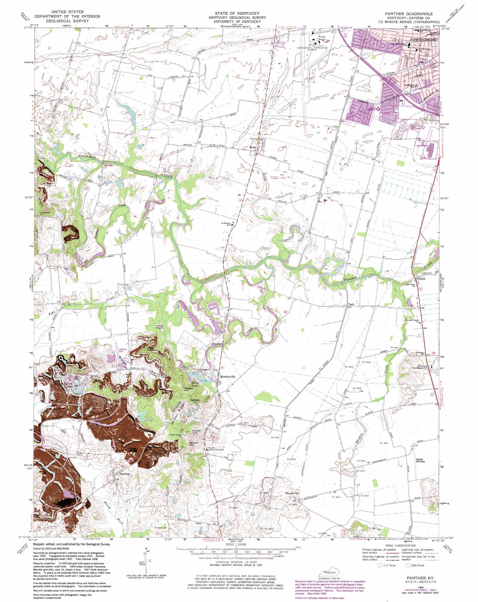
Panther Topo Map Kentucky
To zoom in, hover over the map of Panther
USGS Topo Quad 37087f2 - 1:24,000 scale
| Topo Map Name: | Panther |
| USGS Topo Quad ID: | 37087f2 |
| Print Size: | ca. 21 1/4" wide x 27" high |
| Southeast Coordinates: | 37.625° N latitude / 87.125° W longitude |
| Map Center Coordinates: | 37.6875° N latitude / 87.1875° W longitude |
| U.S. State: | KY |
| Filename: | o37087f2.jpg |
| Download Map JPG Image: | Panther topo map 1:24,000 scale |
| Map Type: | Topographic |
| Topo Series: | 7.5´ |
| Map Scale: | 1:24,000 |
| Source of Map Images: | United States Geological Survey (USGS) |
| Alternate Map Versions: |
Panther KY 1953, updated 1954 Download PDF Buy paper map Panther KY 1956, updated 1957 Download PDF Buy paper map Panther KY 1968, updated 1970 Download PDF Buy paper map Panther KY 1968, updated 1983 Download PDF Buy paper map Panther KY 2010 Download PDF Buy paper map Panther KY 2013 Download PDF Buy paper map Panther KY 2016 Download PDF Buy paper map |
1:24,000 Topo Quads surrounding Panther
Newburgh |
Yankeetown |
Richland City |
Rockport |
Lewisport |
Spottsville |
Reed |
Owensboro West |
Owensboro East |
Maceo |
Delaware |
Curdsville |
Panther |
Sutherland |
Philpot |
Beech Grove |
Calhoun |
Glenville |
Utica |
Pleasant Ridge |
Hanson |
Sacramento |
Livermore |
Equality |
Hartford |
> Back to 37087e1 at 1:100,000 scale
> Back to 37086a1 at 1:250,000 scale
> Back to U.S. Topo Maps home
Panther topo map: Gazetteer
Panther: Airports
Goode Airpark elevation 120m 393′Miles Airport elevation 119m 390′
Owensboro-Daviess County Airport elevation 122m 400′
Panther: Canals
Big Ditch elevation 119m 390′Ford Ditch elevation 119m 390′
Geotz Ditch elevation 116m 380′
Keller Ditch elevation 117m 383′
Vance Ditch elevation 120m 393′
Wolf Branch Ditch elevation 119m 390′
Panther: Lakes
Miller Lake elevation 116m 380′Panther: Populated Places
Handyville elevation 126m 413′Moseleyville elevation 119m 390′
Panther elevation 140m 459′
Pettit elevation 118m 387′
Rome elevation 123m 403′
Tuck elevation 118m 387′
Panther: Reservoirs
Windy Hollow Lakes elevation 137m 449′Panther: Ridges
Nickel Ridge elevation 165m 541′Panther: Streams
Flat Lick Creek elevation 115m 377′Gullett Branch elevation 121m 396′
Old Panther Creek elevation 117m 383′
Panther Creek elevation 113m 370′
Rhodes Creek elevation 114m 374′
Panther: Summits
Dithey Hill elevation 164m 538′Island Field elevation 120m 393′
Nation Hill elevation 169m 554′
Oglesby Hill elevation 166m 544′
Russell Hill elevation 166m 544′
Zion Hill elevation 156m 511′
Panther: Valleys
Windy Hollow elevation 120m 393′Panther digital topo map on disk
Buy this Panther topo map showing relief, roads, GPS coordinates and other geographical features, as a high-resolution digital map file on DVD: