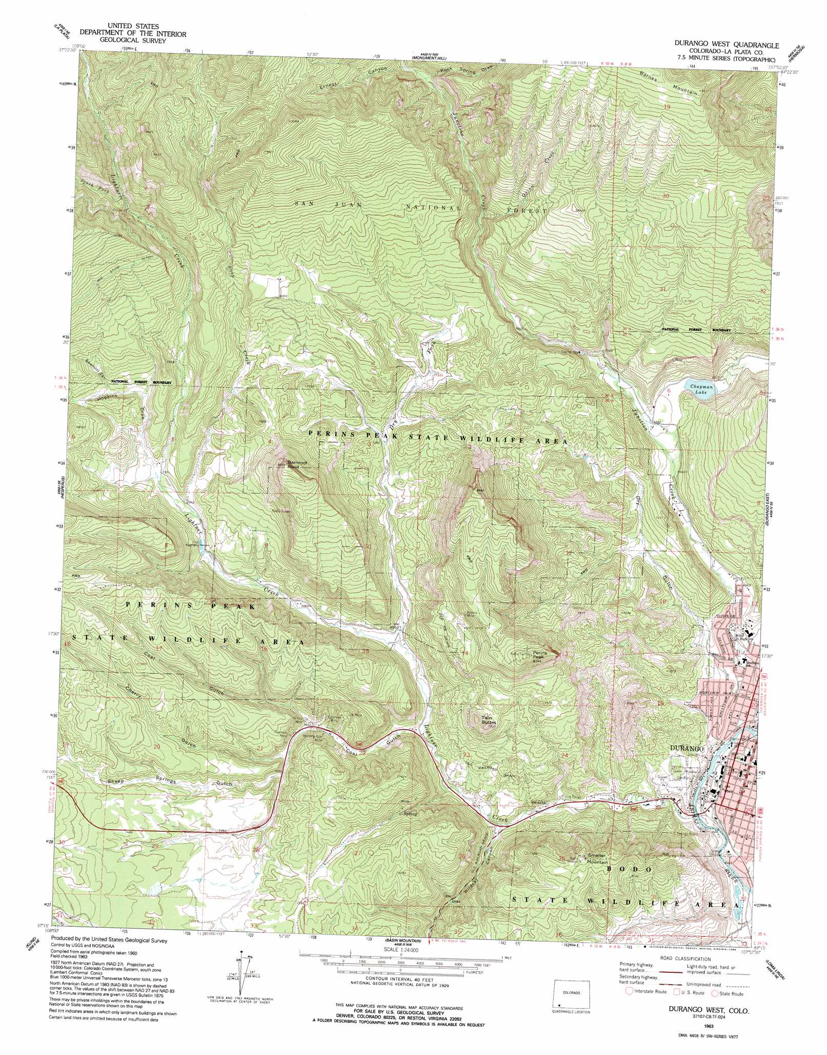
Durango West Topo Map Colorado
To zoom in, hover over the map of Durango West
USGS Topo Quad 37107c8 - 1:24,000 scale
| Topo Map Name: | Durango West |
| USGS Topo Quad ID: | 37107c8 |
| Print Size: | ca. 21 1/4" wide x 27" high |
| Southeast Coordinates: | 37.25° N latitude / 107.875° W longitude |
| Map Center Coordinates: | 37.3125° N latitude / 107.9375° W longitude |
| U.S. State: | CO |
| Filename: | o37107c8.jpg |
| Download Map JPG Image: | Durango West topo map 1:24,000 scale |
| Map Type: | Topographic |
| Topo Series: | 7.5´ |
| Map Scale: | 1:24,000 |
| Source of Map Images: | United States Geological Survey (USGS) |
| Alternate Map Versions: |
Durango West CO 1963, updated 1970 Download PDF Buy paper map Durango West CO 1963, updated 1970 Download PDF Buy paper map Durango West CO 1963, updated 1987 Download PDF Buy paper map Durango West CO 1963, updated 1993 Download PDF Buy paper map Durango West CO 1963, updated 1993 Download PDF Buy paper map Durango West CO 2011 Download PDF Buy paper map Durango West CO 2013 Download PDF Buy paper map Durango West CO 2016 Download PDF Buy paper map |
| FStopo: | US Forest Service topo Durango West is available: Download FStopo PDF Download FStopo TIF |
1:24,000 Topo Quads surrounding Durango West
Wallace Ranch |
Orphan Butte |
Elk Creek |
Electra Lake |
Mountain View Crest |
Rampart Hills |
La Plata |
Monument Hill |
Hermosa |
Lemon Reservoir |
Thompson Park |
Hesperus |
Durango West |
Durango East |
Rules Hill |
Mormon Reservoir |
Kline |
Basin Mountain |
Loma Linda |
Gem Village |
Redmesa |
Pinkerton Mesa |
Long Mountain |
Bondad Hill |
Ignacio |
> Back to 37107a1 at 1:100,000 scale
> Back to 37106a1 at 1:250,000 scale
> Back to U.S. Topo Maps home
Durango West topo map: Gazetteer
Durango West: Bridges
Gardenswartz Memorial Bridge elevation 1986m 6515′Durango West: Cliffs
Barnroof Point elevation 2656m 8713′Durango West: Lakes
Chapman Lake elevation 2091m 6860′Durango West: Mines
Bay Coal Mine elevation 2143m 7030′Bell Quarry elevation 1987m 6519′
Boston Mine elevation 2389m 7837′
C and F Coal Mine elevation 1985m 6512′
Castle Number Four Mine elevation 2226m 7303′
Castle Number Two Mine elevation 2244m 7362′
Champion Gold Mine elevation 1987m 6519′
Coal Gulch Mine elevation 1996m 6548′
Columbine Pit elevation 1987m 6519′
Davis Coal Mine elevation 2146m 7040′
Flicker Group Mine elevation 2527m 8290′
Gold Coin Mine elevation 1987m 6519′
Graves Mine elevation 2311m 7582′
Hazel Mine Group elevation 1987m 6519′
Lady Maureen Mine elevation 2683m 8802′
Lemon Pit elevation 1987m 6519′
Lightner Creek Group Mine elevation 2527m 8290′
Maine Mine elevation 2244m 7362′
McCartney Group Mine elevation 1987m 6519′
Miller Mountain Mine elevation 1987m 6519′
Morning Glory Mine elevation 2219m 7280′
Morning Star Mine elevation 2133m 6998′
Murphy Mine elevation 2265m 7431′
Nevada Mine elevation 2527m 8290′
Ohio-Indiana Mine elevation 2698m 8851′
OK Mine elevation 2182m 7158′
Peerless Mine elevation 2183m 7162′
Pro Patria Tunnel Mine elevation 2129m 6984′
Revenue Tunnel Mine elevation 2129m 6984′
Saint Paul Mine elevation 1987m 6519′
San Juan Mine elevation 2208m 7244′
Siegrist Pit elevation 1987m 6519′
Sunshine Mine elevation 2179m 7148′
Thomas Property Mine elevation 1987m 6519′
Triangle Mine elevation 2214m 7263′
Victory Mine elevation 2147m 7043′
Durango West: Parks
Buckley Park elevation 1986m 6515′Claire Viles Park elevation 1992m 6535′
Fassbinder Park elevation 1992m 6535′
Perins Peak State Wildlife Area elevation 2416m 7926′
Roosa Park elevation 1985m 6512′
Rotary Park elevation 1990m 6528′
Schneider Park elevation 2002m 6568′
Durango West: Populated Places
Durango elevation 1991m 6532′Durango West: Streams
Deep Creek elevation 2201m 7221′Lightner Creek elevation 1976m 6482′
Quinn Creek elevation 2256m 7401′
South Fork Lightner Creek elevation 2438m 7998′
Turkey Creek elevation 2437m 7995′
Durango West: Summits
Perins Peak elevation 2541m 8336′Smelter Mountain elevation 2354m 7723′
Twin Buttes elevation 2319m 7608′
Durango West: Valleys
Cherry Gulch elevation 2153m 7063′Coal Gulch elevation 2144m 7034′
Dry Gulch elevation 2038m 6686′
Ernest Canyon elevation 2367m 7765′
Hopkins Draw elevation 2230m 7316′
Horse Gulch elevation 1977m 6486′
Rock Spring Draw elevation 2350m 7709′
Sawmill Canyon elevation 2290m 7513′
Sheep Springs Gulch elevation 2211m 7253′
Wildcat Canyon elevation 2040m 6692′
Durango West digital topo map on disk
Buy this Durango West topo map showing relief, roads, GPS coordinates and other geographical features, as a high-resolution digital map file on DVD: