Defiance Topo Map Missouri
To zoom in, hover over the map of Defiance
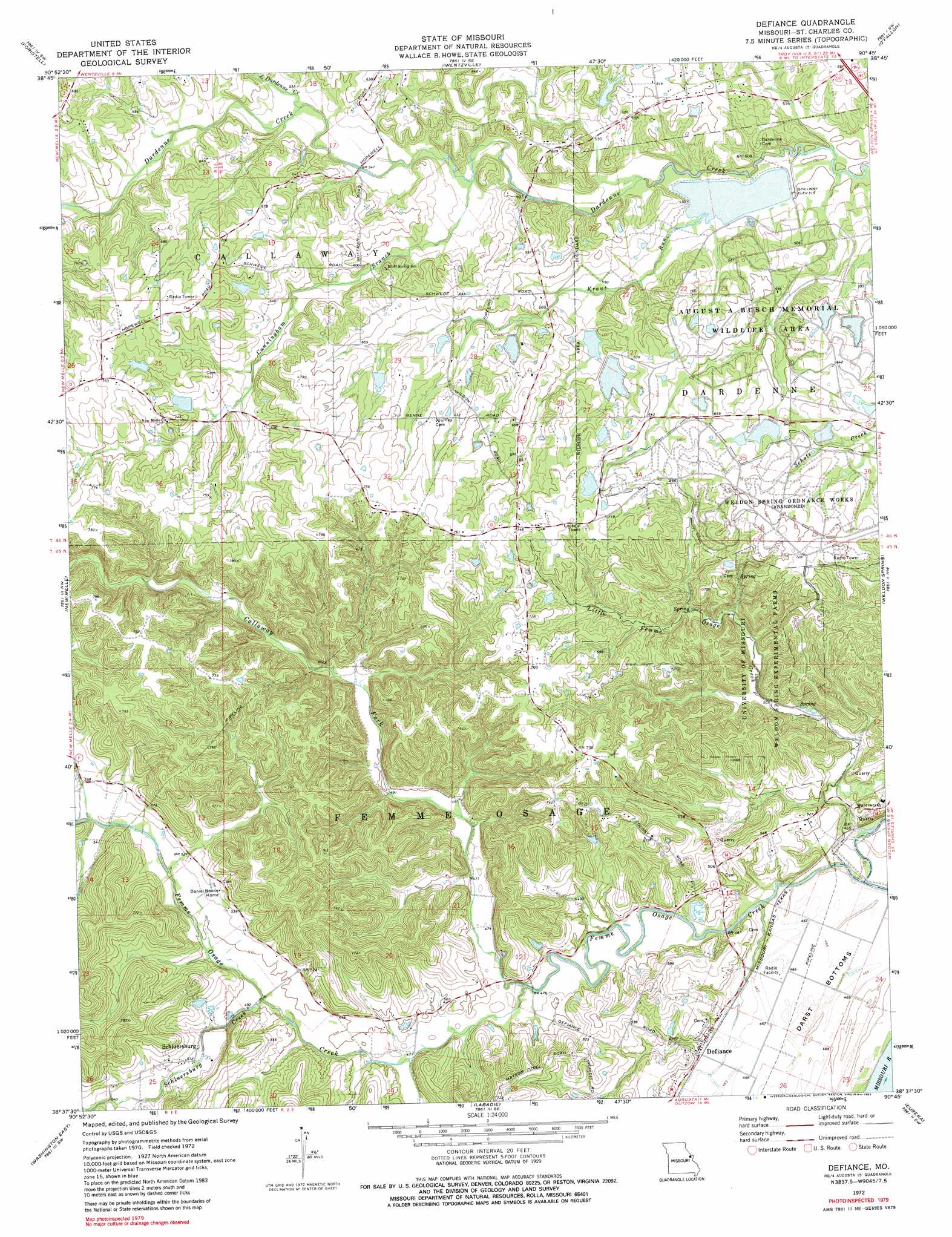
USGS Topo Quad 38090f7 - 1:24,000 scale
| Topo Map Name: | Defiance |
| USGS Topo Quad ID: | 38090f7 |
| Print Size: | ca. 21 1/4" wide x 27" high |
| Southeast Coordinates: | 38.625° N latitude / 90.75° W longitude |
| Map Center Coordinates: | 38.6875° N latitude / 90.8125° W longitude |
| U.S. State: | MO |
| Filename: | o38090f7.jpg |
| Download Map JPG Image: | Defiance topo map 1:24,000 scale |
| Map Type: | Topographic |
| Topo Series: | 7.5´ |
| Map Scale: | 1:24,000 |
| Source of Map Images: | United States Geological Survey (USGS) |
| Alternate Map Versions: |
Defiance MO 1972, updated 1973 Download PDF Buy paper map Defiance MO 1972, updated 1983 Download PDF Buy paper map Defiance MO 1972, updated 1983 Download PDF Buy paper map Defiance MO 2000, updated 2003 Download PDF Buy paper map Defiance MO 2012 Download PDF Buy paper map Defiance MO 2015 Download PDF Buy paper map |
1:24,000 Topo Quads surrounding Defiance
Warrenton Ne |
Troy |
Maryknoll |
Winfield |
Brussels |
Wright City |
Foristell |
Wentzville |
O'Fallon |
Kampville |
Marthasville |
New Melle |
Defiance |
Weldon Spring |
Chesterfield |
Washington West |
Washington East |
Labadie |
Eureka |
Manchester |
Union |
Moselle |
Gray Summit |
Pacific |
House Springs |
> Back to 38090e1 at 1:100,000 scale
> Back to 38090a1 at 1:250,000 scale
> Back to U.S. Topo Maps home
Defiance topo map: Gazetteer
Defiance: Dams
Apprill Lake Dam elevation 197m 646′Arnot Lake Dam elevation 218m 715′
August A Busch Lake Number 15 Dam elevation 180m 590′
August A Busch Lake Number 570 Dam elevation 180m 590′
August A Busch Lake Number 6 Dam elevation 194m 636′
August A Busch Lake Number 600 Dam elevation 180m 590′
August A Busch Lake Number 7 Dam elevation 207m 679′
August A Busch Lake Number 8 Dam elevation 170m 557′
Bridlespur Lake Dam elevation 197m 646′
Brommelsieck Lake Dam elevation 179m 587′
Busch Wildlife Area Section 15 Dam elevation 173m 567′
Busch Wildlife Area Section 27 Dam elevation 192m 629′
Busch Wildlife Area Section 36 Dam elevation 190m 623′
Busch Wildlife Area-Survey 1778 Dam elevation 181m 593′
Busch Wildlife Area-Survey 297 Dam elevation 170m 557′
Fette Lake Dam elevation 200m 656′
Hammel Lake Dam elevation 214m 702′
Hueffmeir Lake Dam elevation 187m 613′
Kraut Run Lake Dam elevation 152m 498′
Lakeview Acres Dam elevation 208m 682′
Mosley Lake Dam elevation 200m 656′
Stevener Lake Dam elevation 201m 659′
Defiance: Parks
August A Busch Memorial Conservation Area elevation 185m 606′Weldon Spring Conservation Area elevation 151m 495′
Defiance: Populated Places
Defiance elevation 146m 479′Howell (historical) elevation 218m 715′
Mechanicsville elevation 217m 711′
Schluersburg elevation 160m 524′
Defiance: Reservoirs
August A Busch Lake Number 15 elevation 180m 590′August A Busch Lake Number 6 elevation 194m 636′
August A Busch Lake Number 7 elevation 207m 679′
August A Busch Lake Number 8 elevation 170m 557′
Belmont Aprill Lake elevation 197m 646′
Brommelsieck Lake elevation 179m 587′
Busch Area Lake Number 570 elevation 180m 590′
Busch Wildlife Area Number 600 Lake elevation 180m 590′
Clyde Mosley Lake elevation 200m 656′
Dunivan Lake elevation 197m 646′
Kraut Run Lake elevation 152m 498′
Defiance: Streams
Callaway Fork elevation 140m 459′Cunningham Branch elevation 160m 524′
Kraut Run elevation 152m 498′
Little Dardenne Creek elevation 165m 541′
Little Femme Osage Creek elevation 137m 449′
Schluersburg Creek elevation 146m 479′
Defiance digital topo map on disk
Buy this Defiance topo map showing relief, roads, GPS coordinates and other geographical features, as a high-resolution digital map file on DVD: