Pilot Hill Topo Map California
To zoom in, hover over the map of Pilot Hill
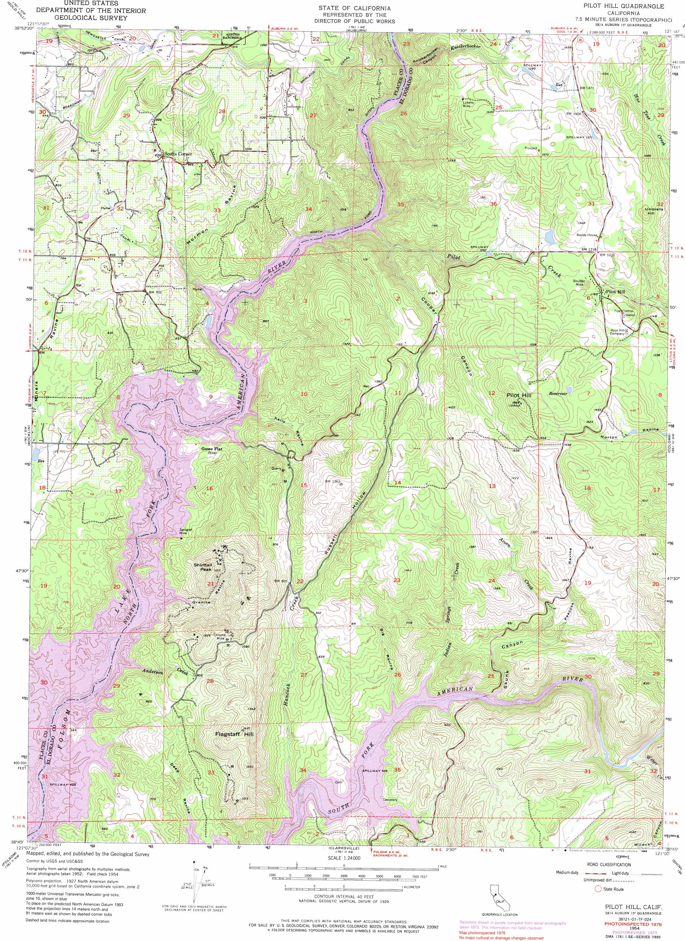
USGS Topo Quad 38121g1 - 1:24,000 scale
| Topo Map Name: | Pilot Hill |
| USGS Topo Quad ID: | 38121g1 |
| Print Size: | ca. 21 1/4" wide x 27" high |
| Southeast Coordinates: | 38.75° N latitude / 121° W longitude |
| Map Center Coordinates: | 38.8125° N latitude / 121.0625° W longitude |
| U.S. State: | CA |
| Filename: | o38121g1.jpg |
| Download Map JPG Image: | Pilot Hill topo map 1:24,000 scale |
| Map Type: | Topographic |
| Topo Series: | 7.5´ |
| Map Scale: | 1:24,000 |
| Source of Map Images: | United States Geological Survey (USGS) |
| Alternate Map Versions: |
Pilot Hill CA 1954, updated 1955 Download PDF Buy paper map Pilot Hill CA 1954, updated 1960 Download PDF Buy paper map Pilot Hill CA 1954, updated 1976 Download PDF Buy paper map Pilot Hill CA 1954, updated 1986 Download PDF Buy paper map Pilot Hill CA 2012 Download PDF Buy paper map Pilot Hill CA 2015 Download PDF Buy paper map |
1:24,000 Topo Quads surrounding Pilot Hill
Camp Far West |
Wolf |
Lake Combie |
Colfax |
Foresthill |
Lincoln |
Gold Hill |
Auburn |
Greenwood |
Georgetown |
Roseville |
Rocklin |
Pilot Hill |
Coloma |
Garden Valley |
Citrus Heights |
Folsom |
Clarksville |
Shingle Springs |
Placerville |
Carmichael |
Buffalo Creek |
Folsom Se |
Latrobe |
Fiddletown |
> Back to 38121e1 at 1:100,000 scale
> Back to 38120a1 at 1:250,000 scale
> Back to U.S. Topo Maps home
Pilot Hill topo map: Gazetteer
Pilot Hill: Bars
Dotsons Bar (historical) elevation 143m 469′Horseshoe Bar (historical) elevation 143m 469′
Rattlesnake Bar (historical) elevation 148m 485′
Whiskey Bar (historical) elevation 143m 469′
Pilot Hill: Bridges
Rattlesnake Bridge (historical) elevation 143m 469′Salmon Falls Bridge elevation 143m 469′
Pilot Hill: Canals
Boardman Canal elevation 310m 1017′Newcastle Canal elevation 372m 1220′
North Fork Ditch elevation 143m 469′
Shirland Canal elevation 398m 1305′
South Canal elevation 256m 839′
Pilot Hill: Dams
Aeree 2463 Dam elevation 358m 1174′Natomas Diversion Dam (historical) elevation 143m 469′
Pilot Hill: Falls
Salmon Falls elevation 143m 469′Pilot Hill: Islands
Oregon Bar (historical) elevation 143m 469′Pilot Hill: Lakes
Averys Pond elevation 145m 475′Pilot Hill: Mines
Boulder Mine elevation 358m 1174′Chrome Mine elevation 321m 1053′
Zantgraf Mine elevation 151m 495′
Pilot Hill: Parks
Anderson Island Natural Preserve elevation 158m 518′Pilot Hill: Populated Places
Lakeshore elevation 208m 682′Pilot Hill elevation 358m 1174′
Salmon Falls (historical) elevation 143m 469′
Zee Estates elevation 201m 659′
Pilot Hill: Streams
Acorn Creek elevation 143m 469′Anderson Creek elevation 147m 482′
Hancock Creek elevation 144m 472′
Indian Springs Creek elevation 145m 475′
Knickerbocker Creek elevation 152m 498′
Pilot Creek elevation 164m 538′
Sweetwater Creek elevation 143m 469′
Weber Creek elevation 145m 475′
Pilot Hill: Summits
Flagstaff Hill elevation 432m 1417′Pilot Hill elevation 566m 1856′
Shirttail Peak elevation 363m 1190′
Umbrella Hill elevation 454m 1489′
Pilot Hill: Valleys
Big Ravine elevation 147m 482′Cooper Canyon elevation 172m 564′
Granite Ravine elevation 143m 469′
Kelly Ravine elevation 143m 469′
Knickerbocker Canyon elevation 152m 498′
Mormon Ravine elevation 143m 469′
Peacock Ravine elevation 220m 721′
Russell Hollow elevation 241m 790′
Skunk Canyon elevation 143m 469′
Wildcat Canyon elevation 168m 551′
Pilot Hill digital topo map on disk
Buy this Pilot Hill topo map showing relief, roads, GPS coordinates and other geographical features, as a high-resolution digital map file on DVD: