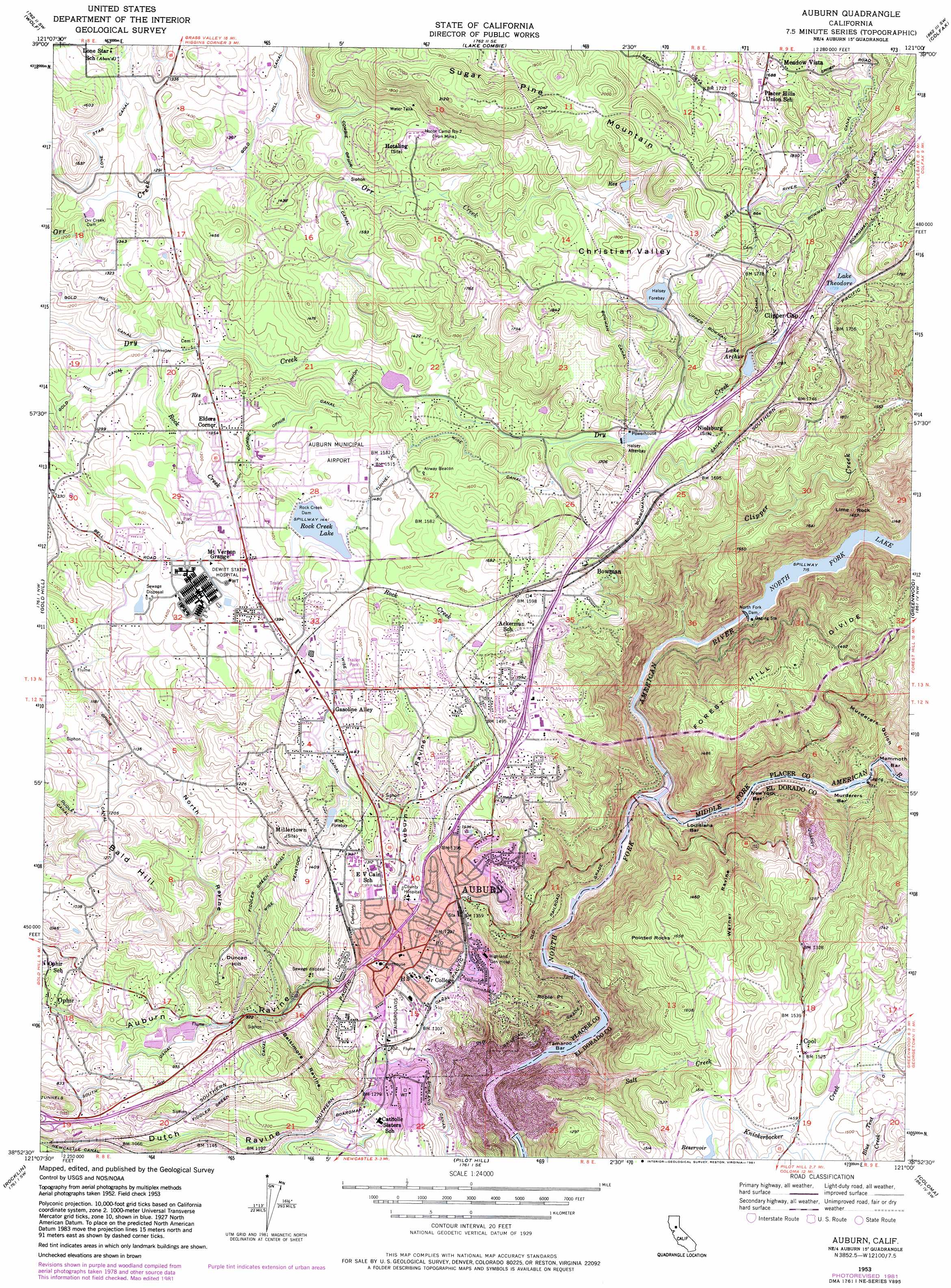
Auburn Topo Map California
To zoom in, hover over the map of Auburn
USGS Topo Quad 38121h1 - 1:24,000 scale
| Topo Map Name: | Auburn |
| USGS Topo Quad ID: | 38121h1 |
| Print Size: | ca. 21 1/4" wide x 27" high |
| Southeast Coordinates: | 38.875° N latitude / 121° W longitude |
| Map Center Coordinates: | 38.9375° N latitude / 121.0625° W longitude |
| U.S. State: | CA |
| Filename: | o38121h1.jpg |
| Download Map JPG Image: | Auburn topo map 1:24,000 scale |
| Map Type: | Topographic |
| Topo Series: | 7.5´ |
| Map Scale: | 1:24,000 |
| Source of Map Images: | United States Geological Survey (USGS) |
| Alternate Map Versions: |
Auburn CA 1953, updated 1955 Download PDF Buy paper map Auburn CA 1953, updated 1961 Download PDF Buy paper map Auburn CA 1953, updated 1972 Download PDF Buy paper map Auburn CA 1953, updated 1972 Download PDF Buy paper map Auburn CA 1953, updated 1977 Download PDF Buy paper map Auburn CA 1953, updated 1977 Download PDF Buy paper map Auburn CA 1953, updated 1981 Download PDF Buy paper map Auburn CA 1953, updated 1981 Download PDF Buy paper map Auburn CA 1953, updated 1981 Download PDF Buy paper map Auburn CA 1975, updated 1981 Download PDF Buy paper map Auburn CA 2012 Download PDF Buy paper map Auburn CA 2015 Download PDF Buy paper map |
1:24,000 Topo Quads surrounding Auburn
Smartville |
Rough And Ready |
Grass Valley |
Chicago Park |
Dutch Flat |
Camp Far West |
Wolf |
Lake Combie |
Colfax |
Foresthill |
Lincoln |
Gold Hill |
Auburn |
Greenwood |
Georgetown |
Roseville |
Rocklin |
Pilot Hill |
Coloma |
Garden Valley |
Citrus Heights |
Folsom |
Clarksville |
Shingle Springs |
Placerville |
> Back to 38121e1 at 1:100,000 scale
> Back to 38120a1 at 1:250,000 scale
> Back to U.S. Topo Maps home
Auburn topo map: Gazetteer
Auburn: Airports
Auburn CDF Heliport elevation 503m 1650′Auburn Municipal Airport elevation 454m 1489′
PG and E-Auburn Service Center Heliport elevation 396m 1299′
Auburn: Bars
Louisiana Bar elevation 167m 547′Mammoth Bar elevation 184m 603′
Murderers Bar elevation 174m 570′
New York Bar elevation 170m 557′
Tamaroo Bar elevation 154m 505′
Auburn: Canals
Bowman Canal elevation 555m 1820′Bowman Feeder Canal elevation 619m 2030′
Fiddler Green Canal elevation 337m 1105′
Gold Hill Canal elevation 414m 1358′
Lone Star Canal elevation 413m 1354′
Ophir Canal elevation 373m 1223′
South Canal elevation 276m 905′
Upper Bowman Canal elevation 552m 1811′
Wise Canal elevation 440m 1443′
Wise Penstock elevation 390m 1279′
Auburn: Crossings
Exit 118 elevation 344m 1128′Exit 119A elevation 361m 1184′
Exit 119B elevation 374m 1227′
Exit 119C elevation 400m 1312′
Exit 120 elevation 435m 1427′
Exit 121 elevation 470m 1541′
Exit 122 elevation 490m 1607′
Exit 123 elevation 472m 1548′
Exit 124 elevation 468m 1535′
Auburn: Dams
Christian Valley 97-015 Dam elevation 467m 1532′Halsey Forebay 97-023 Dam elevation 534m 1751′
Lake Arthur 97-027 Dam elevation 499m 1637′
Lake Theodore 97-031 Dam elevation 531m 1742′
Lakewood 1322 Dam elevation 414m 1358′
North Fork Dam elevation 219m 718′
Orr Creek Dam elevation 388m 1272′
Rock Creek 97-043 Dam elevation 438m 1437′
Rock Creek Dam elevation 440m 1443′
Sewer S Pond 5 1048 Dam elevation 275m 902′
Auburn: Mines
Honor Camp Number Seven elevation 484m 1587′Auburn: Parks
Ashford Park elevation 434m 1423′Auburn District Regional Park elevation 400m 1312′
Auburn Recreation Park elevation 407m 1335′
Auburn State Recreation Area elevation 181m 593′
Christian Valley Park elevation 467m 1532′
Gold Country Fairgrounds elevation 392m 1286′
McCann Stadium elevation 389m 1276′
Old Auburn Historic District elevation 376m 1233′
Spring Meadows Park elevation 446m 1463′
Auburn: Pillars
Lime Rock elevation 418m 1371′Pointed Rocks elevation 502m 1646′
Auburn: Populated Places
Auburn elevation 374m 1227′Auburn Hills Mobile Estates elevation 426m 1397′
Bowman elevation 493m 1617′
Clipper Gap elevation 511m 1676′
Elders Corner elevation 415m 1361′
Golden Chain Mobile Home Park elevation 429m 1407′
Millertown (historical) elevation 371m 1217′
Nielsburg elevation 469m 1538′
North Auburn elevation 448m 1469′
Ophir elevation 208m 682′
Auburn: Post Offices
Auburn Post Office elevation 395m 1295′Cool Post Office elevation 464m 1522′
Auburn: Reservoirs
Halsey Afterbay elevation 452m 1482′Halsey Afterbay elevation 467m 1532′
Halsey Forebay elevation 555m 1820′
Lake Arthur elevation 489m 1604′
Lake Theodore elevation 526m 1725′
North Fork Lake elevation 219m 718′
Rock Creek Lake elevation 440m 1443′
Wise Forebay elevation 434m 1423′
Auburn: Streams
Clipper Creek elevation 169m 554′Middle Fork American River elevation 164m 538′
Rock Creek elevation 362m 1187′
Salt Creek elevation 154m 505′
Auburn: Summits
Bald Hill elevation 405m 1328′Duncan Hill elevation 390m 1279′
Robie Point elevation 367m 1204′
Sugar Pine Mountain elevation 612m 2007′
Auburn: Valleys
Baltimore Ravine elevation 289m 948′Christian Valley elevation 516m 1692′
Murderers Gulch elevation 189m 620′
North Ravine elevation 262m 859′
Warner Ravine elevation 169m 554′
Auburn digital topo map on disk
Buy this Auburn topo map showing relief, roads, GPS coordinates and other geographical features, as a high-resolution digital map file on DVD: