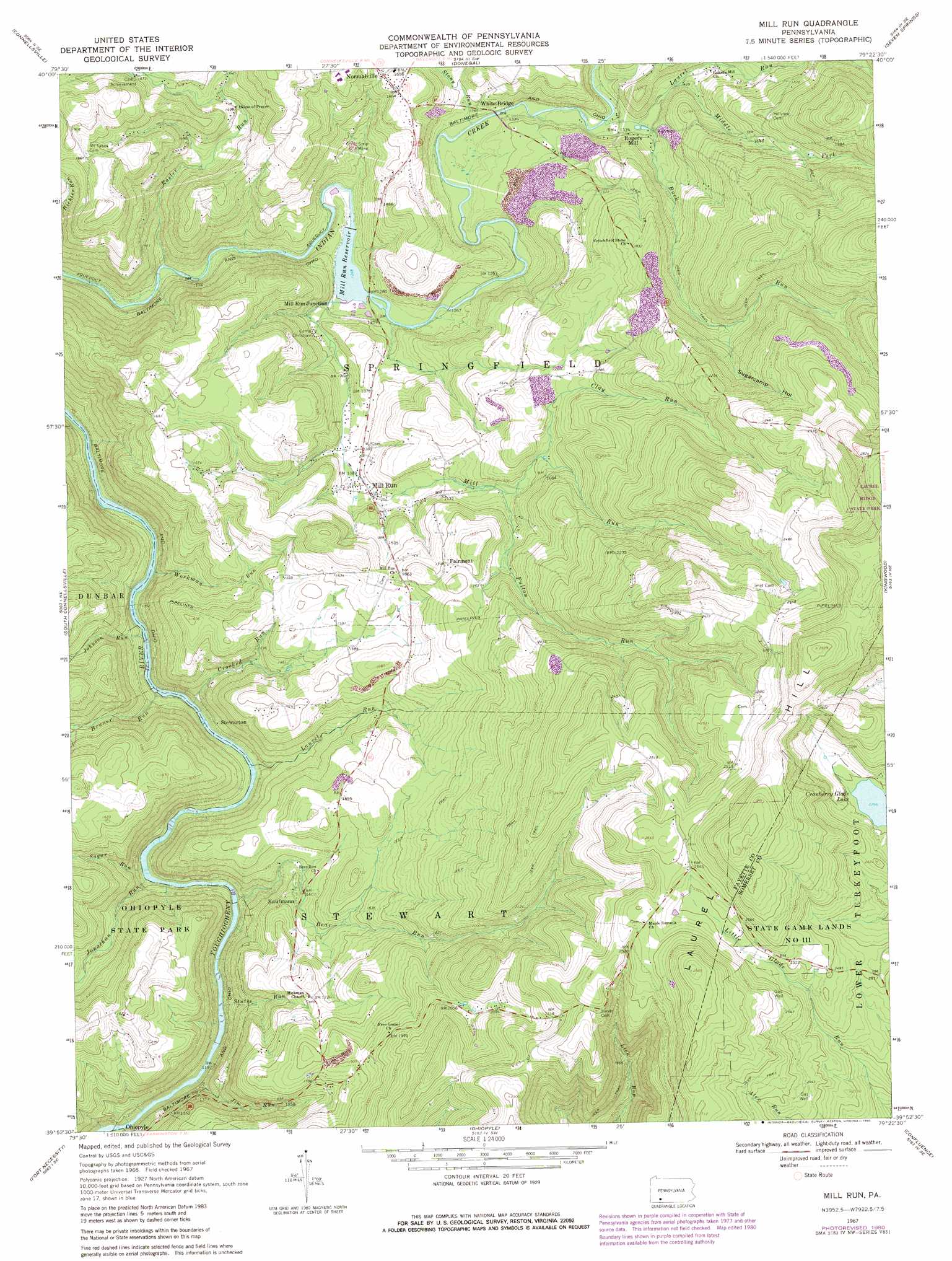
Mill Run Topo Map Pennsylvania
To zoom in, hover over the map of Mill Run
USGS Topo Quad 39079h4 - 1:24,000 scale
| Topo Map Name: | Mill Run |
| USGS Topo Quad ID: | 39079h4 |
| Print Size: | ca. 21 1/4" wide x 27" high |
| Southeast Coordinates: | 39.875° N latitude / 79.375° W longitude |
| Map Center Coordinates: | 39.9375° N latitude / 79.4375° W longitude |
| U.S. State: | PA |
| Filename: | o39079h4.jpg |
| Download Map JPG Image: | Mill Run topo map 1:24,000 scale |
| Map Type: | Topographic |
| Topo Series: | 7.5´ |
| Map Scale: | 1:24,000 |
| Source of Map Images: | United States Geological Survey (USGS) |
| Alternate Map Versions: |
Mill Run PA 1967, updated 1970 Download PDF Buy paper map Mill Run PA 1967, updated 1973 Download PDF Buy paper map Mill Run PA 1967, updated 1980 Download PDF Buy paper map Mill Run PA 1977, updated 1979 Download PDF Buy paper map Mill Run PA 1999, updated 2000 Download PDF Buy paper map Mill Run PA 2010 Download PDF Buy paper map Mill Run PA 2013 Download PDF Buy paper map Mill Run PA 2016 Download PDF Buy paper map |
1:24,000 Topo Quads surrounding Mill Run
Smithton |
Mount Pleasant |
Mammoth |
Stahlstown |
Ligonier |
Saint Clairsville |
Connellsville |
Donegal |
Seven Springs |
Bakersville |
Uniontown |
South Connellsville |
Mill Run |
Kingwood |
Rockwood |
Brownfield |
Fort Necessity |
Ohiopyle |
Confluence |
Markleton |
Bruceton Mills |
Brandonville |
Friendsville |
Accident |
Grantsville |
> Back to 39079e1 at 1:100,000 scale
> Back to 39078a1 at 1:250,000 scale
> Back to U.S. Topo Maps home
Mill Run topo map: Gazetteer
Mill Run: Dams
Indian Creek Dam elevation 375m 1230′Mill Run: Falls
Jonathan Run Falls elevation 352m 1154′Sugar Run Falls elevation 355m 1164′
Mill Run: Populated Places
Fairmont elevation 527m 1729′Kaufmann elevation 446m 1463′
Mill Run elevation 422m 1384′
Mill Run Junction elevation 422m 1384′
Normalville elevation 510m 1673′
Rogers Mill elevation 421m 1381′
Stewarton elevation 344m 1128′
Mill Run: Reservoirs
Indian Creek Reservoir elevation 375m 1230′Mill Run Reservoir elevation 380m 1246′
Mill Run: Streams
Bear Run elevation 334m 1095′Buck Run elevation 421m 1381′
Clay Run elevation 494m 1620′
Crooked Run elevation 317m 1040′
Fulton Run elevation 470m 1541′
Jim Run elevation 356m 1167′
Johnson Run elevation 292m 958′
Jonathan Run elevation 324m 1062′
Laurel Run elevation 309m 1013′
Laurel Run elevation 414m 1358′
Middle Fork Laurel Run elevation 451m 1479′
Mill Run elevation 380m 1246′
Rasler Run elevation 333m 1092′
Stony Run elevation 402m 1318′
Stulls Run elevation 329m 1079′
Sugar Run elevation 314m 1030′
Workman Run elevation 299m 980′
Mill Run: Valleys
Sugarcamp Hollow elevation 566m 1856′Mill Run digital topo map on disk
Buy this Mill Run topo map showing relief, roads, GPS coordinates and other geographical features, as a high-resolution digital map file on DVD:
 map DVD")