Sandford Topo Map Illinois
To zoom in, hover over the map of Sandford
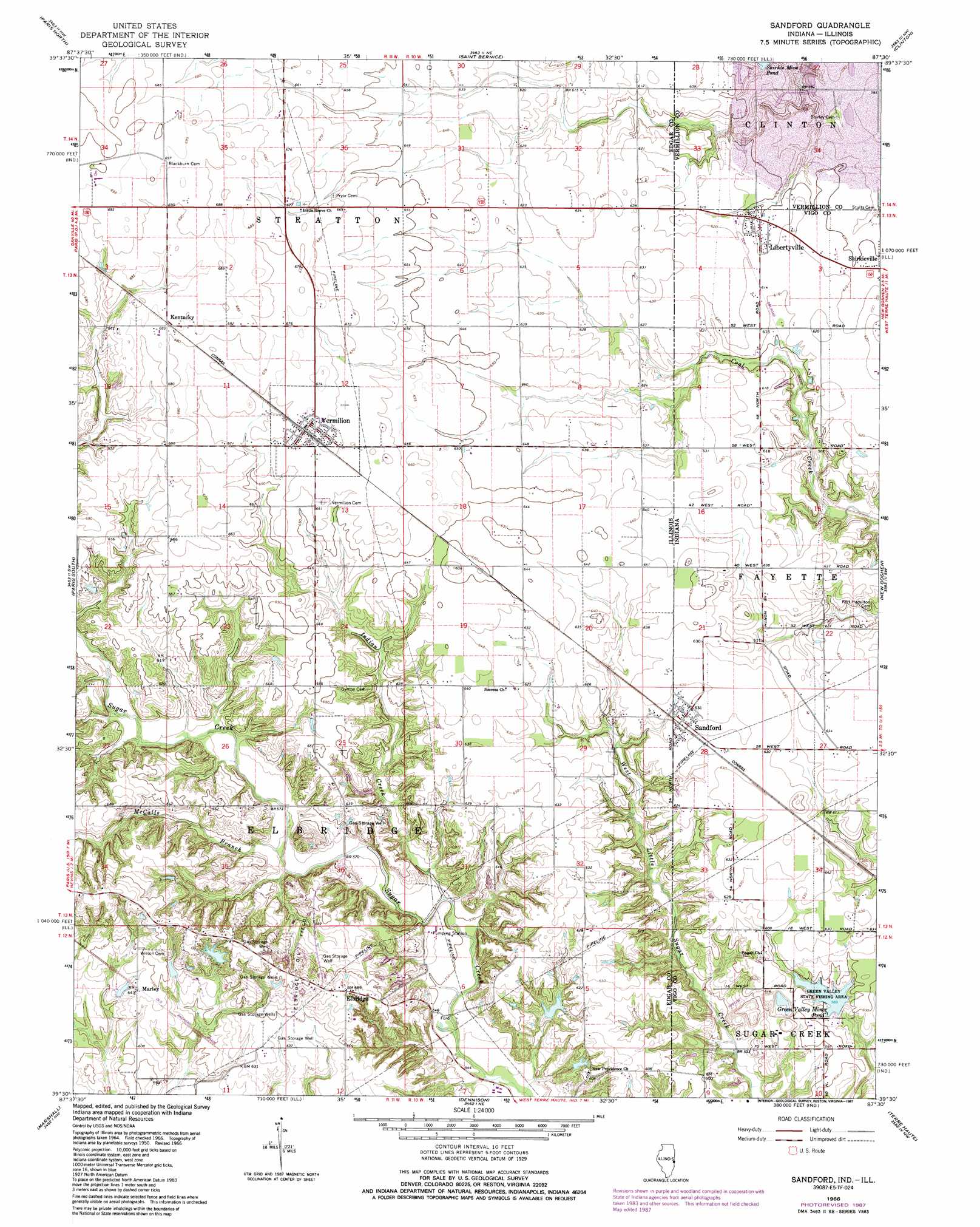
USGS Topo Quad 39087e5 - 1:24,000 scale
| Topo Map Name: | Sandford |
| USGS Topo Quad ID: | 39087e5 |
| Print Size: | ca. 21 1/4" wide x 27" high |
| Southeast Coordinates: | 39.5° N latitude / 87.5° W longitude |
| Map Center Coordinates: | 39.5625° N latitude / 87.5625° W longitude |
| U.S. States: | IL, IN |
| Filename: | o39087e5.jpg |
| Download Map JPG Image: | Sandford topo map 1:24,000 scale |
| Map Type: | Topographic |
| Topo Series: | 7.5´ |
| Map Scale: | 1:24,000 |
| Source of Map Images: | United States Geological Survey (USGS) |
| Alternate Map Versions: |
Sandford IN 1950, updated 1956 Download PDF Buy paper map Sandford IN 1966, updated 1967 Download PDF Buy paper map Sandford IN 1966, updated 1973 Download PDF Buy paper map Sandford IN 1966, updated 1987 Download PDF Buy paper map Sandford IN 1998, updated 2002 Download PDF Buy paper map Sandford IN 2011 Download PDF Buy paper map Sandford IN 2013 Download PDF Buy paper map Sandford IN 2016 Download PDF Buy paper map |
1:24,000 Topo Quads surrounding Sandford
Hume |
Chrisman |
Scottland |
Dana |
Montezuma |
Redmon |
Paris North |
Saint Bernice |
Clinton |
Mecca |
Grandview |
Paris South |
Sandford |
New Goshen |
Rosedale |
Clarksville |
Marshall |
Dennison |
Terre Haute |
Seelyville |
Clark Center |
Snyder |
Hutton |
Pimento |
Lewis |
> Back to 39087e1 at 1:100,000 scale
> Back to 39086a1 at 1:250,000 scale
> Back to U.S. Topo Maps home
Sandford topo map: Gazetteer
Sandford: Dams
Farm Pond Dam elevation 206m 675′Green Valley Mine Pond Dam elevation 178m 583′
Lake Wannetta Dam elevation 193m 633′
Sandford: Lakes
Green Valley Mine Pond elevation 181m 593′Sandford: Oilfields
Elbridge Oil Field elevation 209m 685′Sandford: Parks
Green Valley Public Fishing Area elevation 182m 597′Sandford: Populated Places
Easytown elevation 179m 587′Elbridge elevation 208m 682′
Kentucky elevation 209m 685′
Libertyville elevation 187m 613′
Marley elevation 196m 643′
Sandford elevation 192m 629′
Tighe elevation 177m 580′
Vermilion elevation 205m 672′
West Sandford elevation 191m 626′
Sandford: Reservoirs
Farm Pond elevation 206m 675′Lake Wannetta elevation 193m 633′
Sandford: Streams
Gin Creek elevation 179m 587′Indian Creek elevation 167m 547′
McCalls Branch elevation 171m 561′
Sandford digital topo map on disk
Buy this Sandford topo map showing relief, roads, GPS coordinates and other geographical features, as a high-resolution digital map file on DVD:
Northern Illinois, Northern Indiana & Southwestern Michigan
Buy digital topo maps: Northern Illinois, Northern Indiana & Southwestern Michigan