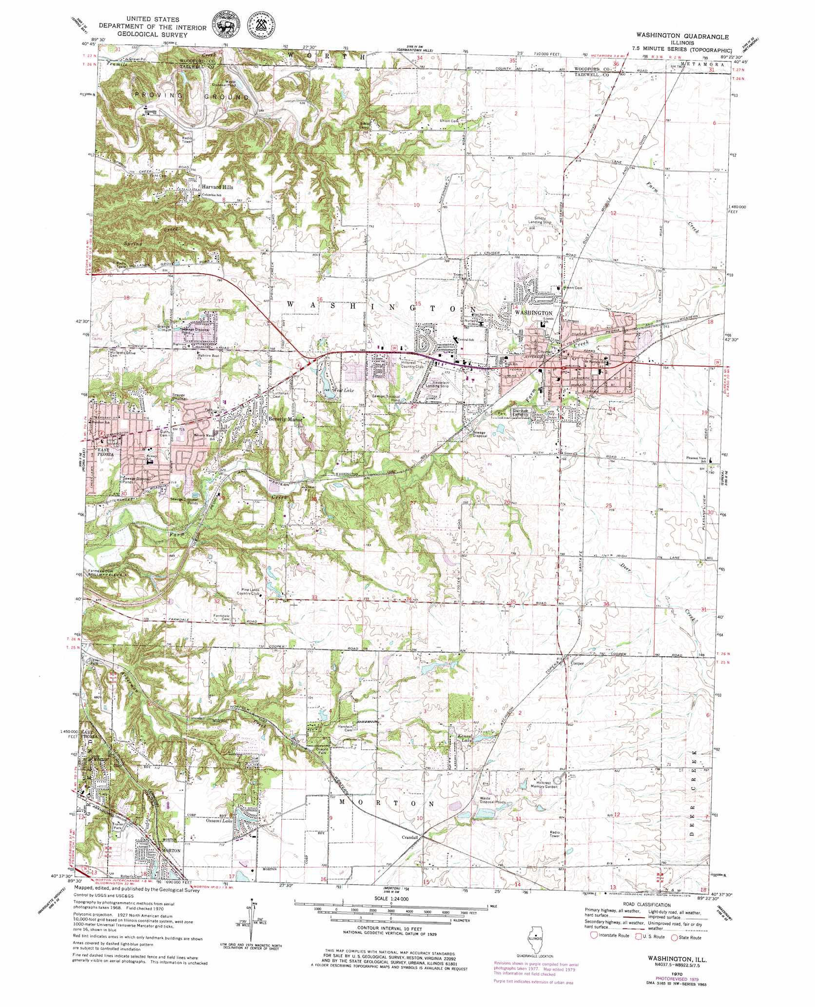
Washington Topo Map Illinois
To zoom in, hover over the map of Washington
USGS Topo Quad 40089f4 - 1:24,000 scale
| Topo Map Name: | Washington |
| USGS Topo Quad ID: | 40089f4 |
| Print Size: | ca. 21 1/4" wide x 27" high |
| Southeast Coordinates: | 40.625° N latitude / 89.375° W longitude |
| Map Center Coordinates: | 40.6875° N latitude / 89.4375° W longitude |
| U.S. State: | IL |
| Filename: | o40089f4.jpg |
| Download Map JPG Image: | Washington topo map 1:24,000 scale |
| Map Type: | Topographic |
| Topo Series: | 7.5´ |
| Map Scale: | 1:24,000 |
| Source of Map Images: | United States Geological Survey (USGS) |
| Alternate Map Versions: |
Washington IL 1970, updated 1972 Download PDF Buy paper map Washington IL 1970, updated 1979 Download PDF Buy paper map Washington IL 1995, updated 1996 Download PDF Buy paper map Washington IL 2012 Download PDF Buy paper map Washington IL 2015 Download PDF Buy paper map |
1:24,000 Topo Quads surrounding Washington
Edelstein |
Rome |
Chillicothe |
Washburn |
La Rose |
Dunlap |
Spring Bay |
Germantown Hills |
Metamora |
Roanoke |
Peoria West |
Peoria East |
Washington |
Eureka |
Secor |
Pekin |
Marquette Heights |
Morton |
Mackinaw |
Danvers |
South Pekin |
Delavan North |
Hopedale |
Minier |
Stanford |
> Back to 40089e1 at 1:100,000 scale
> Back to 40088a1 at 1:250,000 scale
> Back to U.S. Topo Maps home
Washington topo map: Gazetteer
Washington: Airports
Leonard W Hesselien Airport elevation 234m 767′Smittys Airport (historical) elevation 244m 800′
Washington: Dams
Kennel Lake Sportsman Club Lake Dam elevation 249m 816′Libbys Lagoon Number 2 Dam elevation 235m 770′
Libbys Lagoon Number 4 Dam elevation 241m 790′
Pine Lakes Country Club North Pond Dam elevation 216m 708′
Pine Lakes Country Club South Pond Dam elevation 222m 728′
Shepherd Pond Dam elevation 250m 820′
West Lake Dam elevation 229m 751′
Washington: Lakes
Bowen Lake elevation 247m 810′Washington: Parks
Birchwood Park elevation 223m 731′Bowen Lake Park elevation 246m 807′
Bunnell Park elevation 219m 718′
Candlewood Park elevation 223m 731′
Farmdale Recreation Area elevation 184m 603′
Meadow Valley Park elevation 225m 738′
Northwood Park elevation 220m 721′
Oak Ridge Park elevation 237m 777′
Oakwood Park elevation 220m 721′
Sweltzer Park elevation 225m 738′
Thomas Park elevation 211m 692′
Washington Park elevation 235m 770′
Weaver Park elevation 222m 728′
Westwood Park elevation 211m 692′
Washington: Populated Places
Beverly Manor elevation 233m 764′Cooper elevation 247m 810′
Crandall elevation 228m 748′
Harvard Hills elevation 233m 764′
Washington elevation 232m 761′
Washington: Post Offices
Washington Post Office elevation 231m 757′Washington: Reservoirs
Kennel Lake elevation 241m 790′Kennel Lake Sportsman Club Lake elevation 249m 816′
Libbys Lagoon Number 2 elevation 235m 770′
Libbys Lagoon Number 4 elevation 241m 790′
Ossami Lake elevation 211m 692′
Pine Lakes Country Club North Pond elevation 216m 708′
Pine Lakes Country Club South Pond elevation 222m 728′
Shepherd Pond elevation 250m 820′
West Lake elevation 229m 751′
Washington: Streams
Wolf Creek elevation 170m 557′Washington digital topo map on disk
Buy this Washington topo map showing relief, roads, GPS coordinates and other geographical features, as a high-resolution digital map file on DVD:
Northern Illinois, Northern Indiana & Southwestern Michigan
Buy digital topo maps: Northern Illinois, Northern Indiana & Southwestern Michigan