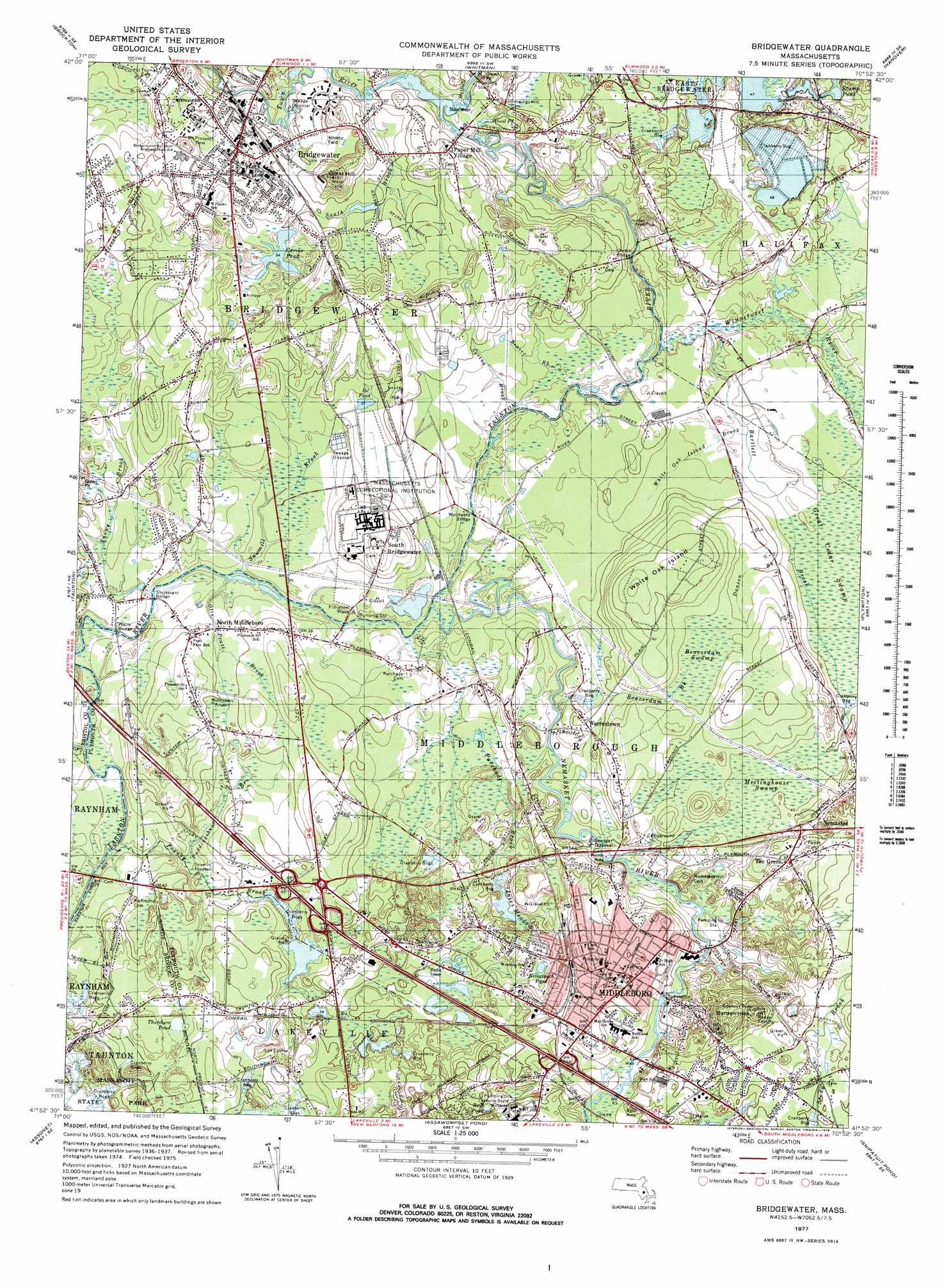
Bridgewater Topo Map Massachusetts
To zoom in, hover over the map of Bridgewater
USGS Topo Quad 41070h8 - 1:25,000 scale
| Topo Map Name: | Bridgewater |
| USGS Topo Quad ID: | 41070h8 |
| Print Size: | ca. 21 1/4" wide x 27" high |
| Southeast Coordinates: | 41.875° N latitude / 70.875° W longitude |
| Map Center Coordinates: | 41.9375° N latitude / 70.9375° W longitude |
| U.S. State: | MA |
| Filename: | l41070h8.jpg |
| Download Map JPG Image: | Bridgewater topo map 1:25,000 scale |
| Map Type: | Topographic |
| Topo Series: | 7.5´ |
| Map Scale: | 1:25,000 |
| Source of Map Images: | United States Geological Survey (USGS) |
| Alternate Map Versions: |
Bridgewater MA 1977, updated 1978 Download PDF Buy paper map Bridgewater MA 1977, updated 1978 Download PDF Buy paper map Bridgewater MA 1977, updated 1981 Download PDF Buy paper map |
1:24,000 Topo Quads surrounding Bridgewater
Blue Hills |
Cohasset |
|||
Brockton |
Whitman |
Hanover |
Duxbury |
|
Taunton |
Bridgewater |
Plympton |
Plymouth |
|
Assonet |
Assawompset Pond |
Snipatuit Pond |
Wareham |
|
Fall River East |
New Bedford North |
Marion |
Onset |
> Back to 41070e1 at 1:100,000 scale
> Back to 41070a1 at 1:250,000 scale
> Back to U.S. Topo Maps home
Bridgewater topo map: Gazetteer
Bridgewater: Airports
Middleboro Airport elevation 17m 55′Saint Lukes Hospital Heliport elevation 37m 121′
Bridgewater: Bridges
Childs Bridge elevation 4m 13′Pratts Bridge elevation 8m 26′
Sturtevant Bridge elevation 8m 26′
Woodward Bridge elevation 9m 29′
Bridgewater: Dams
Carver Pond Dam elevation 16m 52′Crystal Waters Dam elevation 10m 32′
Furnace Street Flume A Dam elevation 10m 32′
Furnace Street Flume B Dam elevation 10m 32′
Reynolds Dam elevation 3m 9′
Route 106 at Robbins Reservoir Dam elevation 14m 45′
Bridgewater: Lakes
Blood Pond elevation 9m 29′Ice Pond elevation 11m 36′
Nevertouch Pond elevation 18m 59′
Thatchers Pond elevation 19m 62′
Bridgewater: Populated Places
Bridgewater elevation 30m 98′Camp Titicut elevation 11m 36′
Middleboro elevation 30m 98′
Namasket Village elevation 11m 36′
Nemasket elevation 26m 85′
North Middleboro elevation 14m 45′
Paper Mill Village elevation 19m 62′
South Bridgewater elevation 19m 62′
The Green elevation 23m 75′
Warrentown elevation 14m 45′
Bridgewater: Post Offices
Bridgewater Post Office (historical) elevation 17m 55′Middleboro Post Office elevation 28m 91′
North Middleborough Post Office (historical) elevation 16m 52′
Bridgewater: Reservoirs
Carver Pond elevation 16m 52′Crystal Waters Reservoir elevation 10m 32′
Robbins Reservoir elevation 14m 45′
Town River Reservoir elevation 3m 9′
Bridgewater: Streams
Bartlett Brook elevation 4m 13′Bassett Brook elevation 8m 26′
Beaver Brook elevation 4m 13′
Beaverdam Brook elevation 5m 16′
Danson Brook elevation 9m 29′
Leonard Washburn Brook elevation 10m 32′
Matfield River elevation 8m 26′
Nemasket River elevation 5m 16′
Otis Pratt Brook elevation 9m 29′
Poquoy Brook elevation 6m 19′
Puddingshear Brook elevation 9m 29′
Purchade Brook elevation 5m 16′
Raven Brook elevation 7m 22′
Sawmill Brook elevation 6m 19′
Snows Brook elevation 6m 19′
South Brook elevation 8m 26′
Spring Brook elevation 4m 13′
Thompson Brook elevation 5m 16′
Town River elevation 8m 26′
White Oak Island Brook elevation 5m 16′
Winnetuxet River elevation 2m 6′
Bridgewater: Summits
Barden Hills elevation 55m 180′Holmes Knoll elevation 21m 68′
Nemasket Hill elevation 26m 85′
White Oak Island elevation 37m 121′
Bridgewater: Swamps
Beaverdam Swamp elevation 21m 68′Joses Meadow elevation 11m 36′
Meetinghouse Swamp elevation 12m 39′
Bridgewater digital topo map on disk
Buy this Bridgewater topo map showing relief, roads, GPS coordinates and other geographical features, as a high-resolution digital map file on DVD:
Maine, New Hampshire, Rhode Island & Eastern Massachusetts
Buy digital topo maps: Maine, New Hampshire, Rhode Island & Eastern Massachusetts