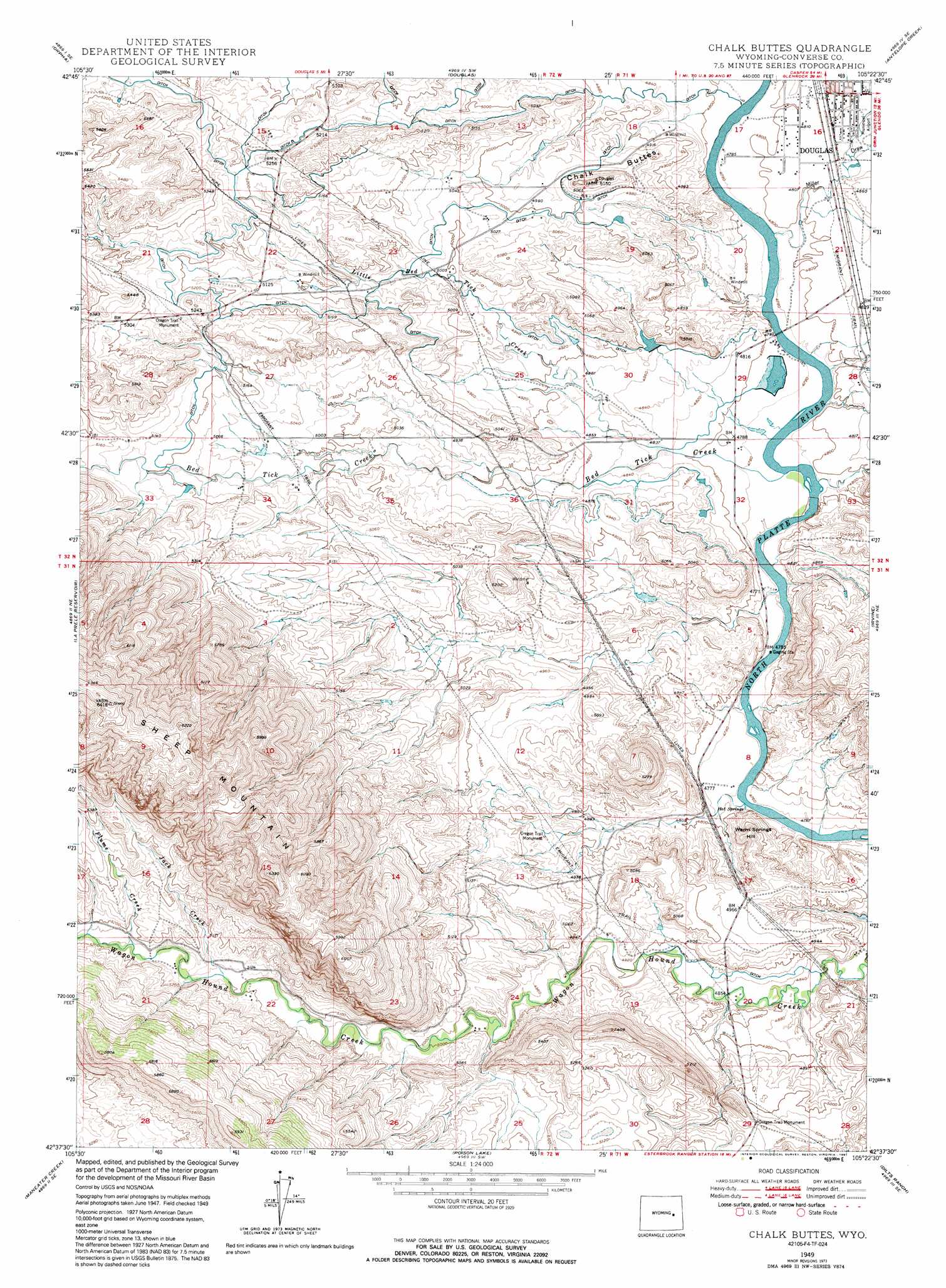
Chalk Buttes Topo Map Wyoming
To zoom in, hover over the map of Chalk Buttes
USGS Topo Quad 42105f4 - 1:24,000 scale
| Topo Map Name: | Chalk Buttes |
| USGS Topo Quad ID: | 42105f4 |
| Print Size: | ca. 21 1/4" wide x 27" high |
| Southeast Coordinates: | 42.625° N latitude / 105.375° W longitude |
| Map Center Coordinates: | 42.6875° N latitude / 105.4375° W longitude |
| U.S. State: | WY |
| Filename: | o42105f4.jpg |
| Download Map JPG Image: | Chalk Buttes topo map 1:24,000 scale |
| Map Type: | Topographic |
| Topo Series: | 7.5´ |
| Map Scale: | 1:24,000 |
| Source of Map Images: | United States Geological Survey (USGS) |
| Alternate Map Versions: |
Chalk Buttes WY 1949, updated 1975 Download PDF Buy paper map Chalk Buttes WY 1949, updated 1981 Download PDF Buy paper map Chalk Buttes WY 1949, updated 1991 Download PDF Buy paper map Chalk Buttes WY 1950 Download PDF Buy paper map Chalk Buttes WY 2012 Download PDF Buy paper map Chalk Buttes WY 2015 Download PDF Buy paper map |
1:24,000 Topo Quads surrounding Chalk Buttes
Leuenberger Ranch |
Gilbert Lake |
Sundquist Ranch |
Clausen Ranch |
Simpson Draw Nw |
Careyhurst |
Orpha |
Douglas |
Antelope Creek |
Simpson Draw |
Hermit Rock |
La Prele Reservoir |
Chalk Buttes |
Irvine |
Orin |
Blue Nose Creek |
Maneater Creek |
Poison Lake |
Dilts Ranch |
Cedar Hill |
School Section Mountain |
Saddleback Mountain |
Braae |
Esterbrook |
Spring Creek |
> Back to 42105e1 at 1:100,000 scale
> Back to 42104a1 at 1:250,000 scale
> Back to U.S. Topo Maps home
Chalk Buttes topo map: Gazetteer
Chalk Buttes: Dams
Busch Dam elevation 1526m 5006′Chalk Buttes Dam elevation 1522m 4993′
Chalk Buttes: Mines
American Mining Company Property Mine elevation 1801m 5908′Sheep Mountain Mine elevation 1802m 5912′
Chalk Buttes: Parks
Oregon Trail Monument elevation 1604m 5262′Oregon Trail Monument elevation 1546m 5072′
Oregon Trail Monument elevation 1505m 4937′
Chalk Buttes: Reservoirs
Busch Reservoir elevation 1526m 5006′Chalk Buttes Reservoir elevation 1522m 4993′
Chalk Buttes: Springs
Douglas Hot Springs elevation 1447m 4747′Chalk Buttes: Streams
Bed Tick Creek elevation 1452m 4763′Flume Creek elevation 1573m 5160′
Jack Creek elevation 1559m 5114′
Little Bed Tick Creek elevation 1470m 4822′
Chalk Buttes: Summits
Chalk Buttes elevation 1559m 5114′Warm Springs Hill elevation 1516m 4973′
Chalk Buttes: Valleys
Miller Draw elevation 1458m 4783′Chalk Buttes digital topo map on disk
Buy this Chalk Buttes topo map showing relief, roads, GPS coordinates and other geographical features, as a high-resolution digital map file on DVD:
Eastern Wyoming & Western South Dakota
Buy digital topo maps: Eastern Wyoming & Western South Dakota