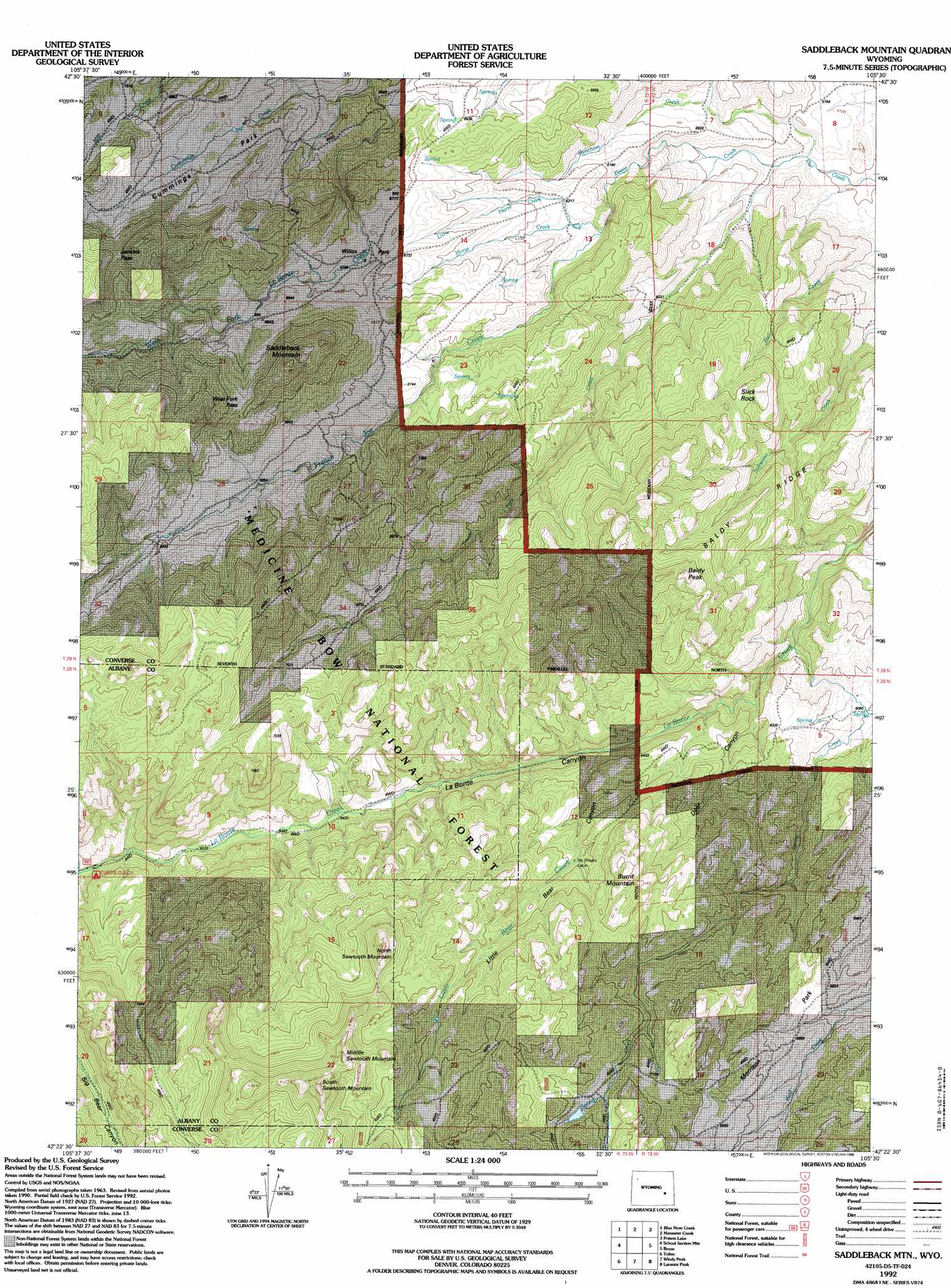
Saddleback Mountain Topo Map Wyoming
To zoom in, hover over the map of Saddleback Mountain
USGS Topo Quad 42105d5 - 1:24,000 scale
| Topo Map Name: | Saddleback Mountain |
| USGS Topo Quad ID: | 42105d5 |
| Print Size: | ca. 21 1/4" wide x 27" high |
| Southeast Coordinates: | 42.375° N latitude / 105.5° W longitude |
| Map Center Coordinates: | 42.4375° N latitude / 105.5625° W longitude |
| U.S. State: | WY |
| Filename: | o42105d5.jpg |
| Download Map JPG Image: | Saddleback Mountain topo map 1:24,000 scale |
| Map Type: | Topographic |
| Topo Series: | 7.5´ |
| Map Scale: | 1:24,000 |
| Source of Map Images: | United States Geological Survey (USGS) |
| Alternate Map Versions: |
Saddleback Mountain WY 1964, updated 1968 Download PDF Buy paper map Saddleback Mountain WY 1964, updated 1985 Download PDF Buy paper map Saddleback Mtn WY 1992, updated 1996 Download PDF Buy paper map Saddleback Mtn WY 1992, updated 1996 Download PDF Buy paper map Saddleback Mountain WY 2012 Download PDF Buy paper map Saddleback Mountain WY 2015 Download PDF Buy paper map |
| FStopo: | US Forest Service topo Saddleback Mountain is available: Download FStopo PDF Download FStopo TIF |
1:24,000 Topo Quads surrounding Saddleback Mountain
Root Creek |
Hermit Rock |
La Prele Reservoir |
Chalk Buttes |
Irvine |
Buffalo Peak |
Blue Nose Creek |
Maneater Creek |
Poison Lake |
Dilts Ranch |
Warbonnett Peak |
School Section Mountain |
Saddleback Mountain |
Braae |
Esterbrook |
Marshall |
Toltec |
Windy Peak |
Laramie Peak |
Harris Park |
Rogers Creek |
Cottonwood Creek |
Cow Creek Mountain |
South Mountain |
Fletcher Park |
> Back to 42105a1 at 1:100,000 scale
> Back to 42104a1 at 1:250,000 scale
> Back to U.S. Topo Maps home
Saddleback Mountain topo map: Gazetteer
Saddleback Mountain: Dams
Dunn Number 1 Dam elevation 2162m 7093′Saddleback Mountain: Flats
Cummings Park elevation 2090m 6856′Morrison Park elevation 2049m 6722′
Willox Park elevation 2065m 6774′
Saddleback Mountain: Gaps
Jenkins Pass elevation 2240m 7349′West Fork Pass elevation 2182m 7158′
Saddleback Mountain: Pillars
Slick Rock elevation 2113m 6932′Saddleback Mountain: Reservoirs
Dunn Reservoir Number 1 elevation 2162m 7093′Saddleback Mountain: Ridges
Baldy Ridge elevation 2132m 6994′Saddleback Mountain: Streams
Bunchem Creek elevation 1718m 5636′Cummings Creek elevation 1989m 6525′
Deere Creek elevation 1728m 5669′
French Joe Creek elevation 1941m 6368′
Horse Creek elevation 1941m 6368′
Little Bear Creek elevation 1911m 6269′
Little Horse Creek elevation 1902m 6240′
South Park Creek elevation 1718m 5636′
Spring Creek elevation 1806m 5925′
Saddleback Mountain: Summits
Baldy Peak elevation 2257m 7404′Burnt Mountain elevation 2271m 7450′
Middle Sawtooth Mountain elevation 2574m 8444′
North Sawtooth Mountain elevation 2468m 8097′
Saddleback Mountain elevation 2271m 7450′
South Sawtooth Mountain elevation 2620m 8595′
Saddleback Mountain: Valleys
Deer Canyon elevation 1852m 6076′Little Bear Canyon elevation 1924m 6312′
Saddleback Mountain digital topo map on disk
Buy this Saddleback Mountain topo map showing relief, roads, GPS coordinates and other geographical features, as a high-resolution digital map file on DVD:
Eastern Wyoming & Western South Dakota
Buy digital topo maps: Eastern Wyoming & Western South Dakota