Chesterfield Res Topo Map Idaho
To zoom in, hover over the map of Chesterfield Res
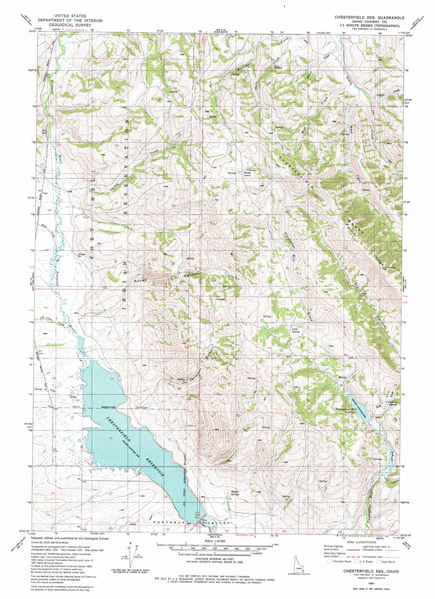
USGS Topo Quad 42111h8 - 1:24,000 scale
| Topo Map Name: | Chesterfield Res |
| USGS Topo Quad ID: | 42111h8 |
| Print Size: | ca. 21 1/4" wide x 27" high |
| Southeast Coordinates: | 42.875° N latitude / 111.875° W longitude |
| Map Center Coordinates: | 42.9375° N latitude / 111.9375° W longitude |
| U.S. State: | ID |
| Filename: | o42111h8.jpg |
| Download Map JPG Image: | Chesterfield Res topo map 1:24,000 scale |
| Map Type: | Topographic |
| Topo Series: | 7.5´ |
| Map Scale: | 1:24,000 |
| Source of Map Images: | United States Geological Survey (USGS) |
| Alternate Map Versions: |
Chesterfield Res ID 1981, updated 1982 Download PDF Buy paper map Chesterfield Reservoir ID 2010 Download PDF Buy paper map Chesterfield Reservoir ID 2013 Download PDF Buy paper map |
1:24,000 Topo Quads surrounding Chesterfield Res
Lincoln Creek |
Higham Peak |
Miner Creek |
Poison Creek |
Long Valley |
Yandell Springs |
Lincoln Peak |
Dunn Basin |
Paradise Valley |
Meadow Creek Mountain |
South Putnam Mountain |
Jeff Cabin Creek |
Chesterfield Res |
Grizzly Creek |
Reservoir Mountain |
Bonneville Peak |
Bear Camp Gulch |
Chesterfield |
Hatch |
The Dip |
Mccammon |
Haystack Mountain |
Bancroft |
Talmage |
Alexander |
> Back to 42111e1 at 1:100,000 scale
> Back to 42110a1 at 1:250,000 scale
> Back to U.S. Topo Maps home
Chesterfield Res topo map: Gazetteer
Chesterfield Res: Dams
Portneuf Dam elevation 1646m 5400′Twentyfour Mile Dam elevation 1801m 5908′
Chesterfield Res: Reservoirs
Chesterfield Reservoir elevation 1646m 5400′Twentyfour Mile Reservoir elevation 1801m 5908′
Chesterfield Res: Springs
Cold Spring elevation 1902m 6240′Corduroy Spring elevation 1831m 6007′
Hibner Spring elevation 1668m 5472′
Chesterfield Res: Streams
Big Jimmy Creek elevation 1693m 5554′Bilious Creek elevation 1822m 5977′
Coyote Creek elevation 1839m 6033′
East Fork Twentyfour Mile Creek elevation 1798m 5898′
Fourth of July Creek elevation 1648m 5406′
Jeff Cabin Creek elevation 1652m 5419′
Rass Creek elevation 1658m 5439′
Rock Creek elevation 1656m 5433′
Spring Creek elevation 1664m 5459′
West Creek elevation 1834m 6017′
Wood Creek elevation 1836m 6023′
Chesterfield Res: Valleys
Jim Corneilson Canyon elevation 1701m 5580′Pole Canyon elevation 1744m 5721′
Rocky Canyon elevation 1653m 5423′
Chesterfield Res digital topo map on disk
Buy this Chesterfield Res topo map showing relief, roads, GPS coordinates and other geographical features, as a high-resolution digital map file on DVD: