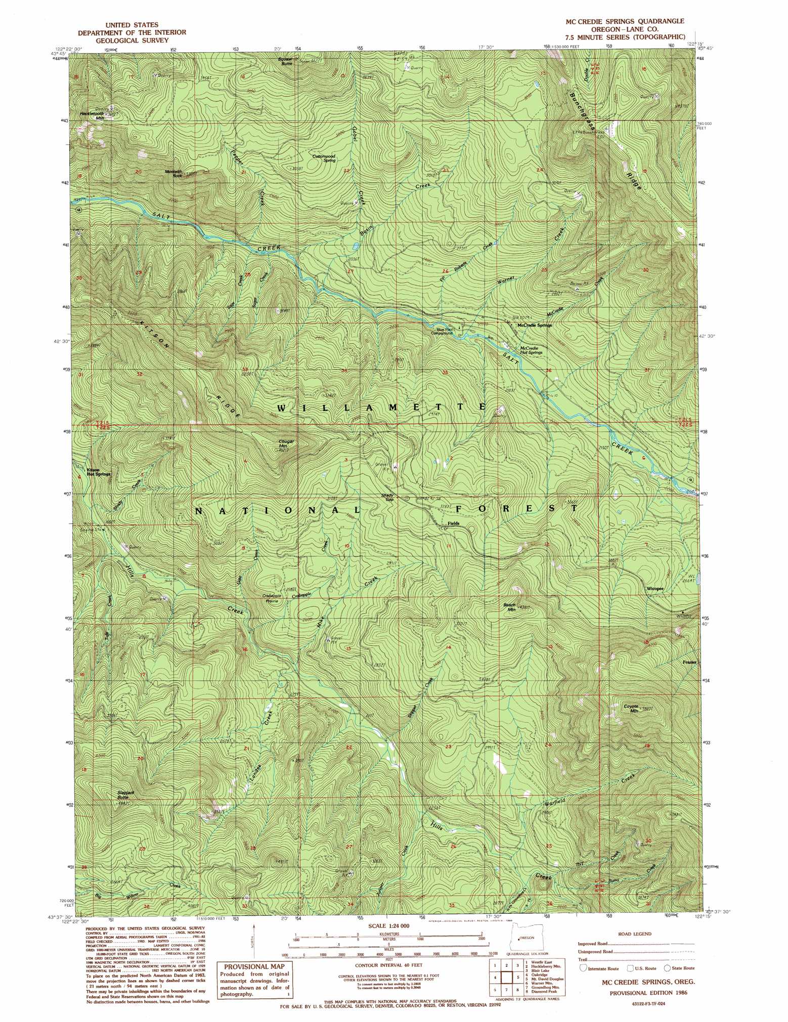
Mccredie Springs Topo Map Oregon
To zoom in, hover over the map of Mccredie Springs
USGS Topo Quad 43122f3 - 1:24,000 scale
| Topo Map Name: | Mccredie Springs |
| USGS Topo Quad ID: | 43122f3 |
| Print Size: | ca. 21 1/4" wide x 27" high |
| Southeast Coordinates: | 43.625° N latitude / 122.25° W longitude |
| Map Center Coordinates: | 43.6875° N latitude / 122.3125° W longitude |
| U.S. State: | OR |
| Filename: | o43122f3.jpg |
| Download Map JPG Image: | Mccredie Springs topo map 1:24,000 scale |
| Map Type: | Topographic |
| Topo Series: | 7.5´ |
| Map Scale: | 1:24,000 |
| Source of Map Images: | United States Geological Survey (USGS) |
| Alternate Map Versions: |
Mc Credie Springs OR 1986, updated 1986 Download PDF Buy paper map Mc Credie Springs OR 1997, updated 1998 Download PDF Buy paper map McCredie Springs OR 2011 Download PDF Buy paper map McCredie Springs OR 2014 Download PDF Buy paper map |
| FStopo: | US Forest Service topo McCredie Springs is available: Download FStopo PDF Download FStopo TIF |
1:24,000 Topo Quads surrounding Mccredie Springs
Saddleblanket Mountain |
Sinker Mountain |
Sardine Butte |
Grasshopper Mountain |
Chucksney Mountain |
Westfir West |
Westfir East |
Huckleberry Mountain |
Blair Lake |
Waldo Mountain |
Holland Point |
Oakridge |
Mccredie Springs |
Mount David Douglas |
Waldo Lake |
Bearbones Mountain |
Warner Mountain |
Groundhog Mountain |
Diamond Peak |
Willamette Pass |
Reynolds Ridge |
Staley Ridge |
Rigdon Point |
Emigrant Butte |
Cowhorn Mountain |
> Back to 43122e1 at 1:100,000 scale
> Back to 43122a1 at 1:250,000 scale
> Back to U.S. Topo Maps home
Mccredie Springs topo map: Gazetteer
Mccredie Springs: Flats
Crabapple Prairie elevation 806m 2644′Mccredie Springs: Gaps
Shady Gap elevation 1003m 3290′Mccredie Springs: Pillars
Monteith Rock elevation 981m 3218′Mccredie Springs: Populated Places
McCredie Springs elevation 629m 2063′Mccredie Springs: Post Offices
McCredie Springs Post Office (historical) elevation 629m 2063′Mccredie Springs: Ridges
Kitson Ridge elevation 1164m 3818′Mccredie Springs: Springs
Cottonwood Spring elevation 880m 2887′McCredie Hot Springs elevation 613m 2011′
Mccredie Springs: Streams
Basin Creek elevation 552m 1811′Burro Creek elevation 782m 2565′
Crabapple Creek elevation 586m 1922′
Fin Roberts Creek elevation 584m 1916′
Gate Creek elevation 563m 1847′
Gobel Creek elevation 534m 1751′
Juniper Creek elevation 679m 2227′
Landes Creek elevation 608m 1994′
McCredie Creek elevation 606m 1988′
Mike Creek elevation 619m 2030′
North Fork Groundhog Creek elevation 754m 2473′
Pepper Creek elevation 513m 1683′
Sage Creek elevation 508m 1666′
Shady Creek elevation 502m 1646′
Skipper Creek elevation 646m 2119′
South Fork Groundhog Creek elevation 754m 2473′
Sugar Creek elevation 522m 1712′
TNT Creek elevation 779m 2555′
Tufti Creek elevation 511m 1676′
Warfield Creek elevation 731m 2398′
Warner Creek elevation 595m 1952′
Mccredie Springs: Summits
Beach Mountain elevation 1333m 4373′Cougar Mountain elevation 1378m 4520′
Coyote Mountain elevation 1774m 5820′
Heckletooth Mountain elevation 1102m 3615′
Kwiskwis Butte elevation 1400m 4593′
Slapjack Butte elevation 1463m 4799′
Mccredie Springs: Trails
Bunchgrass Trail elevation 973m 3192′Gobel Creek Trail elevation 672m 2204′
Kitson Ridge Trail elevation 1115m 3658′
Owl Cabin Way elevation 1097m 3599′
Squaw Butte Trail elevation 1067m 3500′
Mccredie Springs digital topo map on disk
Buy this Mccredie Springs topo map showing relief, roads, GPS coordinates and other geographical features, as a high-resolution digital map file on DVD: