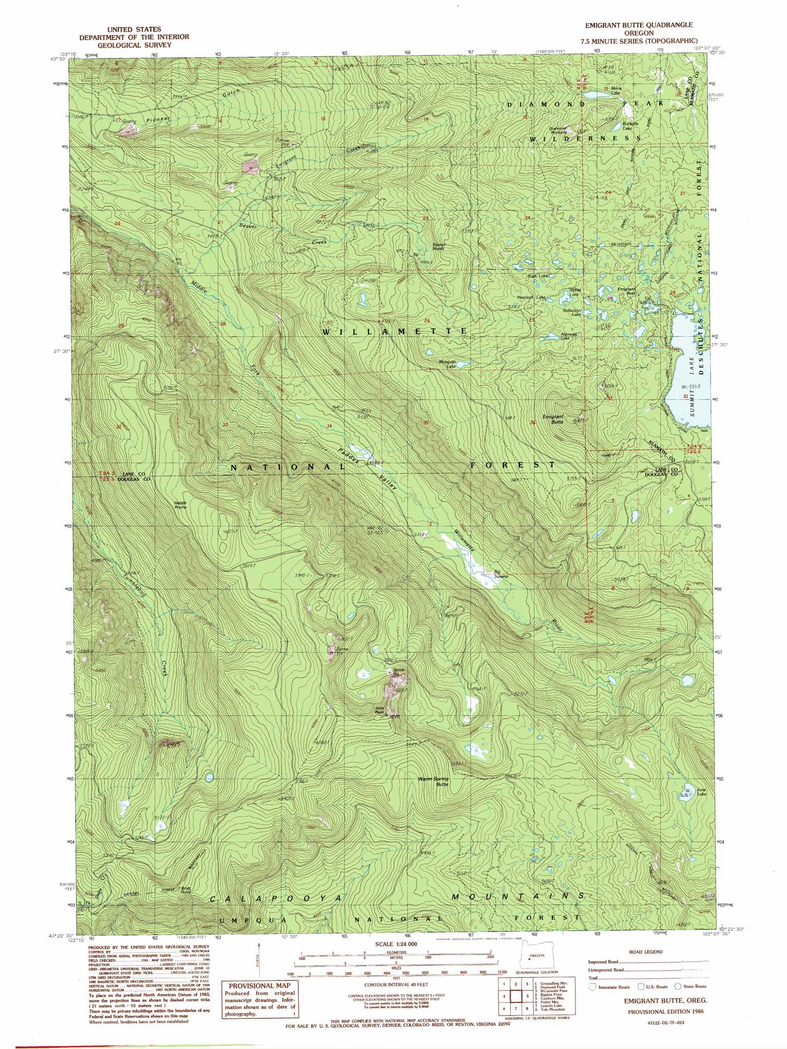
Emigrant Butte Topo Map Oregon
To zoom in, hover over the map of Emigrant Butte
USGS Topo Quad 43122d2 - 1:24,000 scale
| Topo Map Name: | Emigrant Butte |
| USGS Topo Quad ID: | 43122d2 |
| Print Size: | ca. 21 1/4" wide x 27" high |
| Southeast Coordinates: | 43.375° N latitude / 122.125° W longitude |
| Map Center Coordinates: | 43.4375° N latitude / 122.1875° W longitude |
| U.S. State: | OR |
| Filename: | o43122d2.jpg |
| Download Map JPG Image: | Emigrant Butte topo map 1:24,000 scale |
| Map Type: | Topographic |
| Topo Series: | 7.5´ |
| Map Scale: | 1:24,000 |
| Source of Map Images: | United States Geological Survey (USGS) |
| Alternate Map Versions: |
Emigrant Butte OR 1986, updated 1986 Download PDF Buy paper map Emigrant Butte OR 1997, updated 1998 Download PDF Buy paper map Emigrant Butte OR 2011 Download PDF Buy paper map Emigrant Butte OR 2014 Download PDF Buy paper map |
| FStopo: | US Forest Service topo Emigrant Butte is available: Download FStopo PDF Download FStopo TIF |
1:24,000 Topo Quads surrounding Emigrant Butte
Oakridge |
Mccredie Springs |
Mount David Douglas |
Waldo Lake |
The Twins |
Warner Mountain |
Groundhog Mountain |
Diamond Peak |
Willamette Pass |
Odell Lake |
Staley Ridge |
Rigdon Point |
Emigrant Butte |
Cowhorn Mountain |
Crescent Lake |
Toketee Falls |
Potter Mountain |
Lemolo Lake |
Tolo Mountain |
Burn Butte |
Fish Creek Desert |
Garwood Butte |
Diamond Lake |
Mount Thielsen |
Miller Lake |
> Back to 43122a1 at 1:100,000 scale
> Back to 43122a1 at 1:250,000 scale
> Back to U.S. Topo Maps home
Emigrant Butte topo map: Gazetteer
Emigrant Butte: Flats
Happy Prairie elevation 1752m 5748′Emigrant Butte: Gaps
Emigrant Pass elevation 1722m 5649′Emigrant Butte: Lakes
Alameda Lake elevation 1680m 5511′Alpine Lake elevation 1670m 5479′
Bug Lake elevation 1521m 4990′
Fir Lake elevation 1684m 5524′
Hemlock Lake elevation 1669m 5475′
June Lake elevation 1719m 5639′
Marie Lake elevation 1833m 6013′
Mosquito Lake elevation 1633m 5357′
Neet Lake elevation 1668m 5472′
Reflection Lake elevation 1682m 5518′
Rockpile Lake elevation 1833m 6013′
Ruth Lake elevation 1659m 5442′
Spruce Lake elevation 1684m 5524′
Sunrise Lake elevation 1696m 5564′
Sunset Lake elevation 1696m 5564′
Emigrant Butte: Streams
Beaver Creek elevation 973m 3192′Emigrant Creek elevation 1032m 3385′
Emigrant Butte: Summits
Birds Point elevation 1822m 5977′Diamond Rockpile elevation 1829m 6000′
Emigrant Butte elevation 1967m 6453′
Hills Peak elevation 1833m 6013′
Warm Spring Butte elevation 1774m 5820′
Emigrant Butte: Swamps
Beaver Marsh elevation 1417m 4648′Big Swamp elevation 1141m 3743′
Emigrant Butte: Trails
Happy Prairie Way elevation 1832m 6010′McGowan Mountain Way elevation 1262m 4140′
Pioneer Way elevation 1367m 4484′
Sawtooth Way elevation 1911m 6269′
Swamp Way elevation 1096m 3595′
Timpanogas Way elevation 1649m 5410′
Emigrant Butte: Valleys
Paddys Valley elevation 998m 3274′Emigrant Butte digital topo map on disk
Buy this Emigrant Butte topo map showing relief, roads, GPS coordinates and other geographical features, as a high-resolution digital map file on DVD: