Dora Topo Map Oregon
To zoom in, hover over the map of Dora
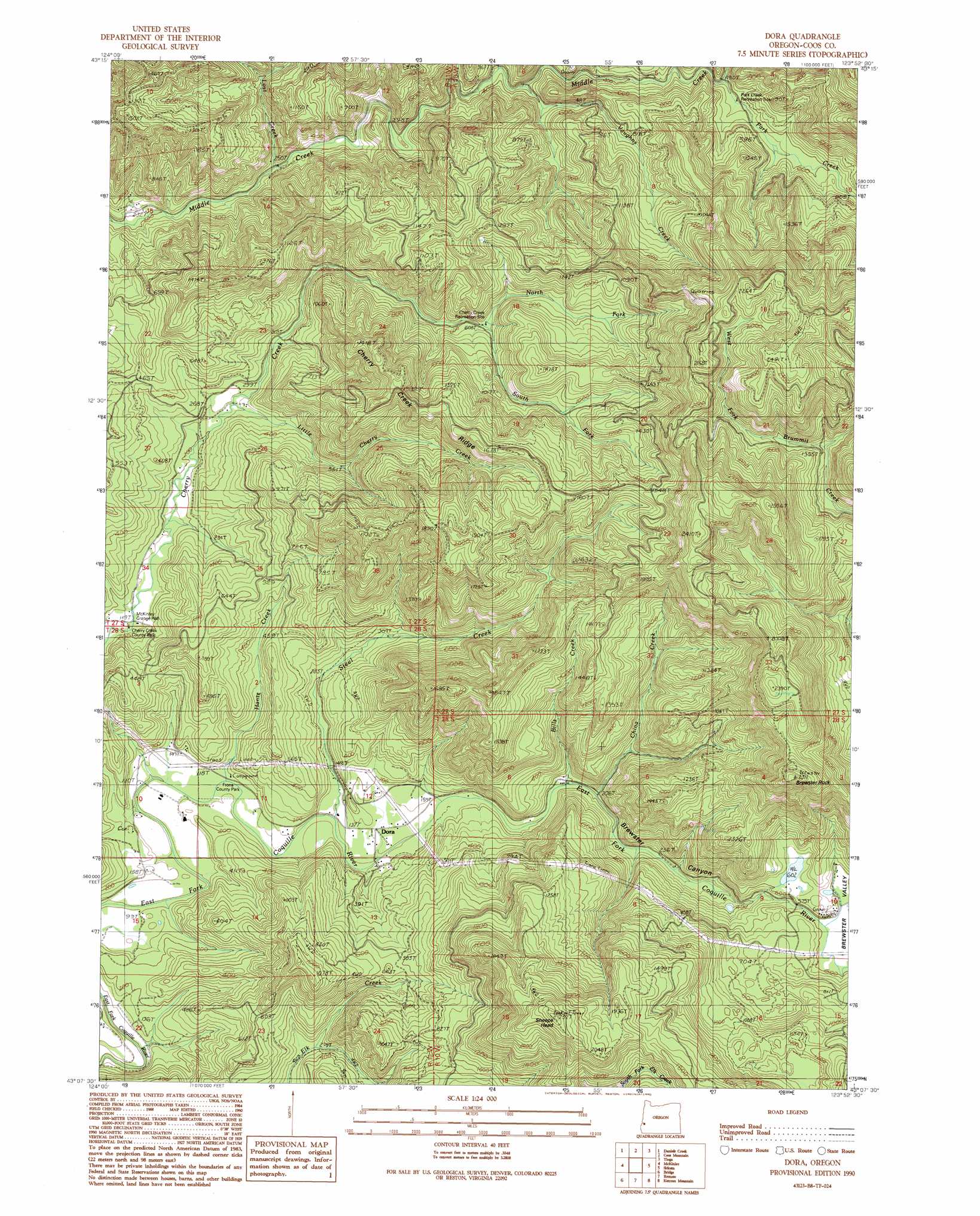
USGS Topo Quad 43123b8 - 1:24,000 scale
| Topo Map Name: | Dora |
| USGS Topo Quad ID: | 43123b8 |
| Print Size: | ca. 21 1/4" wide x 27" high |
| Southeast Coordinates: | 43.125° N latitude / 123.875° W longitude |
| Map Center Coordinates: | 43.1875° N latitude / 123.9375° W longitude |
| U.S. State: | OR |
| Filename: | o43123b8.jpg |
| Download Map JPG Image: | Dora topo map 1:24,000 scale |
| Map Type: | Topographic |
| Topo Series: | 7.5´ |
| Map Scale: | 1:24,000 |
| Source of Map Images: | United States Geological Survey (USGS) |
| Alternate Map Versions: |
Dora OR 1990, updated 1990 Download PDF Buy paper map Dora OR 2011 Download PDF Buy paper map Dora OR 2014 Download PDF Buy paper map |
1:24,000 Topo Quads surrounding Dora
North Bend |
Allegany |
Golden Falls |
Ivers Peak |
Kelly Butte |
Coos Bay |
Daniels Creek |
Coos Mountain |
Tioga |
Cedar Creek |
Coquille |
Mckinley |
Dora |
Sitkum |
Mount Gurney |
Myrtle Point |
Bridge |
Remote |
Kenyon Mountain |
Camas Valley |
Dement Creek |
Powers |
Rasler Creek |
Bone Mountain |
Chipmunk Ridge |
> Back to 43123a1 at 1:100,000 scale
> Back to 43122a1 at 1:250,000 scale
> Back to U.S. Topo Maps home
Dora topo map: Gazetteer
Dora: Parks
Cherry Creek Recreation Site elevation 206m 675′Frona County Park elevation 25m 82′
Ham Bunch - Cherry Creek County Park elevation 93m 305′
Middle Creek Recreation Site elevation 74m 242′
Park Creek Recreation Site elevation 147m 482′
Dora: Pillars
Brewster Rock elevation 671m 2201′Dora: Populated Places
Dora elevation 45m 147′Dora: Post Offices
Dora Post Office (historical) elevation 45m 147′Dora: Ridges
Cherry Creek Ridge elevation 465m 1525′Dora: Streams
Alder Creek elevation 109m 357′Bills Creek elevation 46m 150′
China Creek elevation 84m 275′
East Fork China Creek elevation 134m 439′
Hantz Creek elevation 23m 75′
Karl Creek elevation 401m 1315′
Little Cherry Creek elevation 68m 223′
Lost Creek elevation 74m 242′
Maple Creek elevation 171m 561′
Nellie Creek elevation 56m 183′
North Fork Cherry Creek elevation 188m 616′
Park Creek elevation 152m 498′
Reeves Creek elevation 301m 987′
South Fork Cherry Creek elevation 206m 675′
Steel Creek elevation 32m 104′
Vaughns Creek elevation 110m 360′
Dora: Summits
Sheeps Head elevation 709m 2326′Dora: Valleys
Brewster Canyon elevation 40m 131′Brewster Valley elevation 164m 538′
Dora digital topo map on disk
Buy this Dora topo map showing relief, roads, GPS coordinates and other geographical features, as a high-resolution digital map file on DVD: