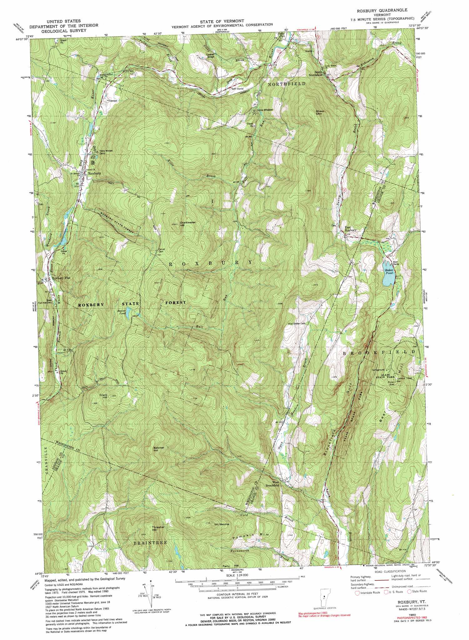
Roxbury Topo Map Vermont
To zoom in, hover over the map of Roxbury
USGS Topo Quad 44072a6 - 1:24,000 scale
| Topo Map Name: | Roxbury |
| USGS Topo Quad ID: | 44072a6 |
| Print Size: | ca. 21 1/4" wide x 27" high |
| Southeast Coordinates: | 44° N latitude / 72.625° W longitude |
| Map Center Coordinates: | 44.0625° N latitude / 72.6875° W longitude |
| U.S. State: | VT |
| Filename: | o44072a6.jpg |
| Download Map JPG Image: | Roxbury topo map 1:24,000 scale |
| Map Type: | Topographic |
| Topo Series: | 7.5´ |
| Map Scale: | 1:24,000 |
| Source of Map Images: | United States Geological Survey (USGS) |
| Alternate Map Versions: |
Roxbury VT 1980, updated 1981 Download PDF Buy paper map Roxbury VT 1980, updated 1991 Download PDF Buy paper map Roxbury VT 1984, updated 1991 Download PDF Buy paper map Roxbury VT 2012 Download PDF Buy paper map Roxbury VT 2015 Download PDF Buy paper map |
1:24,000 Topo Quads surrounding Roxbury
Huntington |
Waterbury |
Middlesex |
Montpelier |
Plainfield |
Mount Ellen |
Waitsfield |
Northfield |
Barre West |
Barre East |
Lincoln |
Warren |
Roxbury |
Brookfield |
Washington |
Bread Loaf |
Hancock |
Randolph |
Randolph Center |
Chelsea |
Mount Carmel |
Rochester |
Bethel |
South Royalton |
Sharon |
> Back to 44072a1 at 1:100,000 scale
> Back to 44072a1 at 1:250,000 scale
> Back to U.S. Topo Maps home
Roxbury topo map: Gazetteer
Roxbury: Bridges
Stony Brook Covered Bridge elevation 272m 892′Roxbury: Dams
Baker Pond Dam elevation 395m 1295′Roxbury: Forests
Roxbury State Forest elevation 472m 1548′Roxbury: Lakes
Beaver Pond elevation 523m 1715′Wardner Pond elevation 391m 1282′
Roxbury: Parks
Allis State Park elevation 615m 2017′Roxbury: Populated Places
East Roxbury elevation 350m 1148′Roxbury elevation 305m 1000′
South Northfield elevation 252m 826′
West Brookfield elevation 324m 1062′
Roxbury: Reservoirs
Baker Pond elevation 395m 1295′Roxbury: Ridges
Pumpkin Rim elevation 456m 1496′Roxbury: Streams
Bull Run elevation 241m 790′Cold Brook elevation 243m 797′
Ellis Brook elevation 352m 1154′
Felchner Brook elevation 266m 872′
Flint Brook elevation 310m 1017′
Open Meadow Brook elevation 241m 790′
Robinson Brook elevation 293m 961′
Stony Brook elevation 259m 849′
Sunny Brook elevation 226m 741′
Woodard Brook elevation 313m 1026′
Roxbury: Summits
Bear Hill elevation 595m 1952′Belcher Hill elevation 696m 2283′
Cram Hill elevation 539m 1768′
Drinkwater Hill elevation 631m 2070′
Mount Nevins elevation 651m 2135′
Shaw Mountain elevation 566m 1856′
Thresher Hill elevation 627m 2057′
Roxbury: Trails
Bear Hill Trail elevation 620m 2034′Roxbury: Valleys
Brookfield Gulf elevation 247m 810′Roxbury digital topo map on disk
Buy this Roxbury topo map showing relief, roads, GPS coordinates and other geographical features, as a high-resolution digital map file on DVD:
New York, Vermont, Connecticut & Western Massachusetts
Buy digital topo maps: New York, Vermont, Connecticut & Western Massachusetts