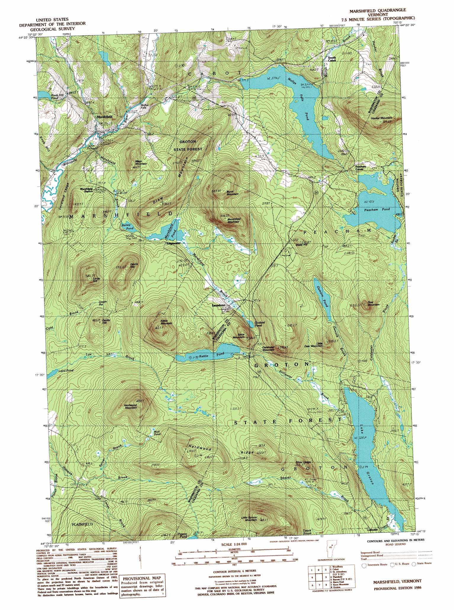
Marshfield Topo Map Vermont
To zoom in, hover over the map of Marshfield
USGS Topo Quad 44072c3 - 1:24,000 scale
| Topo Map Name: | Marshfield |
| USGS Topo Quad ID: | 44072c3 |
| Print Size: | ca. 21 1/4" wide x 27" high |
| Southeast Coordinates: | 44.25° N latitude / 72.25° W longitude |
| Map Center Coordinates: | 44.3125° N latitude / 72.3125° W longitude |
| U.S. State: | VT |
| Filename: | o44072c3.jpg |
| Download Map JPG Image: | Marshfield topo map 1:24,000 scale |
| Map Type: | Topographic |
| Topo Series: | 7.5´ |
| Map Scale: | 1:24,000 |
| Source of Map Images: | United States Geological Survey (USGS) |
| Alternate Map Versions: |
Marshfield VT 1986, updated 1987 Download PDF Buy paper map Marshfield VT 2012 Download PDF Buy paper map Marshfield VT 2015 Download PDF Buy paper map |
1:24,000 Topo Quads surrounding Marshfield
Morrisville |
W0Lcott |
Caspian Lake |
Stannard |
Lyndonville |
Mount Worcester |
Woodbury |
Cabot |
Saint Johnsbury |
|
Montpelier |
Plainfield |
Marshfield |
Barnet |
|
Barre West |
Barre East |
Knox Mountain |
Groton |
Woodsville |
Brookfield |
Washington |
West Topsham |
East Corinth |
Newbury |
> Back to 44072a1 at 1:100,000 scale
> Back to 44072a1 at 1:250,000 scale
> Back to U.S. Topo Maps home
Marshfield topo map: Gazetteer
Marshfield: Beaches
Boulder Beach elevation 328m 1076′Marshfield: Benches
Loveland Ledge elevation 286m 938′Silver Ledge elevation 562m 1843′
Marshfield: Dams
Bailey Pond Dam elevation 379m 1243′Groton Pond Dam elevation 329m 1079′
Laird Pond Dam elevation 347m 1138′
Marshfield Number 6 Dam elevation 392m 1286′
Peacham Pond Dam elevation 421m 1381′
Richards Dam elevation 333m 1092′
Marshfield: Falls
Mollys Falls elevation 257m 843′Marshfield: Flats
Cream Pot Meadow elevation 407m 1335′Marshfield: Forests
Groton State Forest elevation 383m 1256′Marshfield Municipal Forest elevation 466m 1528′
Marshfield: Lakes
Beaver Pond elevation 355m 1164′Goslant Pond elevation 416m 1364′
Kettle Pond elevation 440m 1443′
Knob Hill Pond elevation 369m 1210′
Lake Groton elevation 328m 1076′
Mud Pond elevation 515m 1689′
Osmore Pond elevation 446m 1463′
Turtlehead Pond elevation 392m 1286′
Marshfield: Parks
Big Deer Recreation Area elevation 343m 1125′Boulder Beach Recreation Area elevation 329m 1079′
New Discovery Recreation Area elevation 528m 1732′
Stillwater Recreation Area elevation 338m 1108′
Marshfield: Populated Places
Edgewater elevation 397m 1302′Lakeside elevation 349m 1145′
Lanesboro elevation 421m 1381′
Marshfield elevation 243m 797′
Peacham Corner elevation 419m 1374′
South Cabot elevation 433m 1420′
Marshfield: Post Offices
Marshfield Post Office elevation 251m 823′Marshfield: Reservoirs
Bailey Pond elevation 379m 1243′Groton Pond elevation 329m 1079′
Laird Pond elevation 347m 1138′
Mollys Falls Pond elevation 392m 1286′
Peacham Pond elevation 421m 1381′
Marshfield: Ridges
Hardwood Ridge elevation 670m 2198′Marshfield: Streams
Beaver Brook elevation 328m 1076′Coldwater Brook elevation 328m 1076′
Depot Brook elevation 349m 1145′
Kidder Brook elevation 438m 1437′
Lanes Brook elevation 424m 1391′
Marshfield Brook elevation 237m 777′
Mollys Brook elevation 258m 846′
Osmore Brook elevation 329m 1079′
Spicer Brook elevation 445m 1459′
Stillwater Brook elevation 329m 1079′
Sucker Brook elevation 427m 1400′
Marshfield: Summits
Blake Hill elevation 573m 1879′Burnt Mountain elevation 686m 2250′
Debby Hill elevation 479m 1571′
Deer Mountain elevation 598m 1961′
Devils Hill elevation 566m 1856′
Drew Mountain elevation 588m 1929′
Hardwood Mountain elevation 662m 2171′
Hooker Mountain elevation 701m 2299′
Kettle Mountain elevation 654m 2145′
Little Deer Mountain elevation 529m 1735′
Little Spruce Mountain elevation 758m 2486′
Lords Hill elevation 566m 1856′
Marshfield Mountain elevation 643m 2109′
Mays Mountain elevation 405m 1328′
Owlshead Mountain elevation 553m 1814′
Spice Mountain elevation 560m 1837′
Marshfield: Trails
Big Deer Mountain Trail elevation 499m 1637′Coldwater Brook Trail elevation 371m 1217′
Groton State Forest Nature Trail elevation 339m 1112′
Hosmer Brook Trail elevation 390m 1279′
Kettle Pond Trail elevation 440m 1443′
Little Deer Trail elevation 489m 1604′
Osmore Pond Hiking Loop elevation 457m 1499′
Owls Head Trail elevation 580m 1902′
Silver Ledge Trail elevation 471m 1545′
Marshfield digital topo map on disk
Buy this Marshfield topo map showing relief, roads, GPS coordinates and other geographical features, as a high-resolution digital map file on DVD:
New York, Vermont, Connecticut & Western Massachusetts
Buy digital topo maps: New York, Vermont, Connecticut & Western Massachusetts