Sutton Topo Map Vermont
To zoom in, hover over the map of Sutton
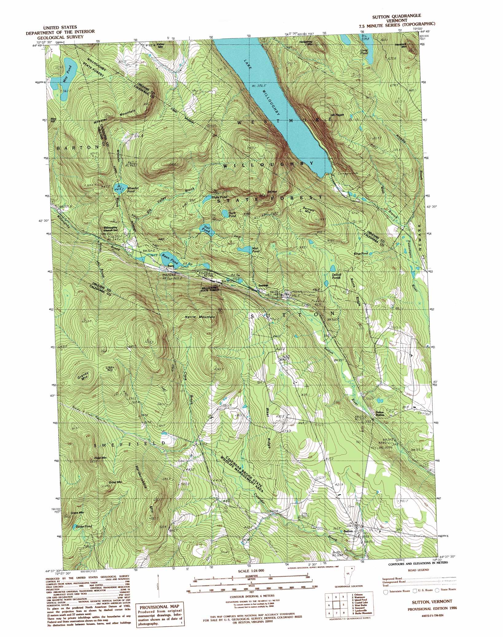
USGS Topo Quad 44072f1 - 1:24,000 scale
| Topo Map Name: | Sutton |
| USGS Topo Quad ID: | 44072f1 |
| Print Size: | ca. 21 1/4" wide x 27" high |
| Southeast Coordinates: | 44.625° N latitude / 72° W longitude |
| Map Center Coordinates: | 44.6875° N latitude / 72.0625° W longitude |
| U.S. State: | VT |
| Filename: | o44072f1.jpg |
| Download Map JPG Image: | Sutton topo map 1:24,000 scale |
| Map Type: | Topographic |
| Topo Series: | 7.5´ |
| Map Scale: | 1:24,000 |
| Source of Map Images: | United States Geological Survey (USGS) |
| Alternate Map Versions: |
Sutton VT 1986, updated 1987 Download PDF Buy paper map Sutton VT 1986, updated 1987 Download PDF Buy paper map Sutton VT 2012 Download PDF Buy paper map Sutton VT 2015 Download PDF Buy paper map |
1:24,000 Topo Quads surrounding Sutton
Newport Center |
Newport |
West Charleston |
Morgan Center |
Norton Pond |
Irasburg |
Orleans |
Westmore |
Island Pond |
Spectacle Pond |
Craftsbury |
Crystal Lake |
Sutton |
West Burke |
Seneca Mountain |
Caspian Lake |
Stannard |
Lyndonville |
Burke Mountain |
Gallup Mills |
Cabot |
Saint Johnsbury |
Concord |
Miles Pond |
> Back to 44072e1 at 1:100,000 scale
> Back to 44072a1 at 1:250,000 scale
> Back to U.S. Topo Maps home
Sutton topo map: Gazetteer
Sutton: Dams
May Pond Dam elevation 501m 1643′Sutton: Forests
Sheffield Municipal Forest elevation 587m 1925′Willoughby State Forest elevation 345m 1131′
Sutton: Lakes
Bean Pond elevation 363m 1190′Blake Pond elevation 481m 1578′
Blake Pond elevation 509m 1669′
Dolloff Ponds elevation 434m 1423′
Duck Pond elevation 527m 1729′
Kings Pond elevation 442m 1450′
Marl Pond elevation 484m 1587′
May Pond elevation 501m 1643′
Negro Pond elevation 555m 1820′
Vail Pond elevation 459m 1505′
Sutton: Parks
Calendar Brook State Wildlife Management Area elevation 409m 1341′Sutton: Populated Places
Perry elevation 364m 1194′Summit elevation 364m 1194′
Sunmit elevation 363m 1190′
Sutton elevation 370m 1213′
Willoughby elevation 347m 1138′
Sutton: Ridges
North Ridge elevation 490m 1607′West Ridge elevation 492m 1614′
Sutton: Streams
Annis Brook elevation 349m 1145′Arcadia Brook elevation 355m 1164′
Big Valley Brook elevation 384m 1259′
Clark Brook elevation 429m 1407′
Richies Run elevation 468m 1535′
Wheeler Brook elevation 364m 1194′
Sutton: Summits
Bartlett Mountain elevation 620m 2034′Frost Mountain elevation 664m 2178′
Granby Mountain elevation 725m 2378′
Grays Mountain elevation 519m 1702′
Grout Mountain elevation 647m 2122′
Hardscrabble Mountain elevation 680m 2230′
Haystack Mountain elevation 790m 2591′
Hedgehog Mountain elevation 661m 2168′
Libby Hill elevation 695m 2280′
Mount Hor elevation 810m 2657′
Mount Pisgah elevation 849m 2785′
Norris Mountain elevation 692m 2270′
Wheeler Mountain elevation 721m 2365′
Sutton: Trails
Herbert Hawkes Hiking Trail elevation 724m 2375′Mount Pisgah Trail elevation 765m 2509′
South Shore Hiking Trail elevation 377m 1236′
Sutton digital topo map on disk
Buy this Sutton topo map showing relief, roads, GPS coordinates and other geographical features, as a high-resolution digital map file on DVD:
New York, Vermont, Connecticut & Western Massachusetts
Buy digital topo maps: New York, Vermont, Connecticut & Western Massachusetts