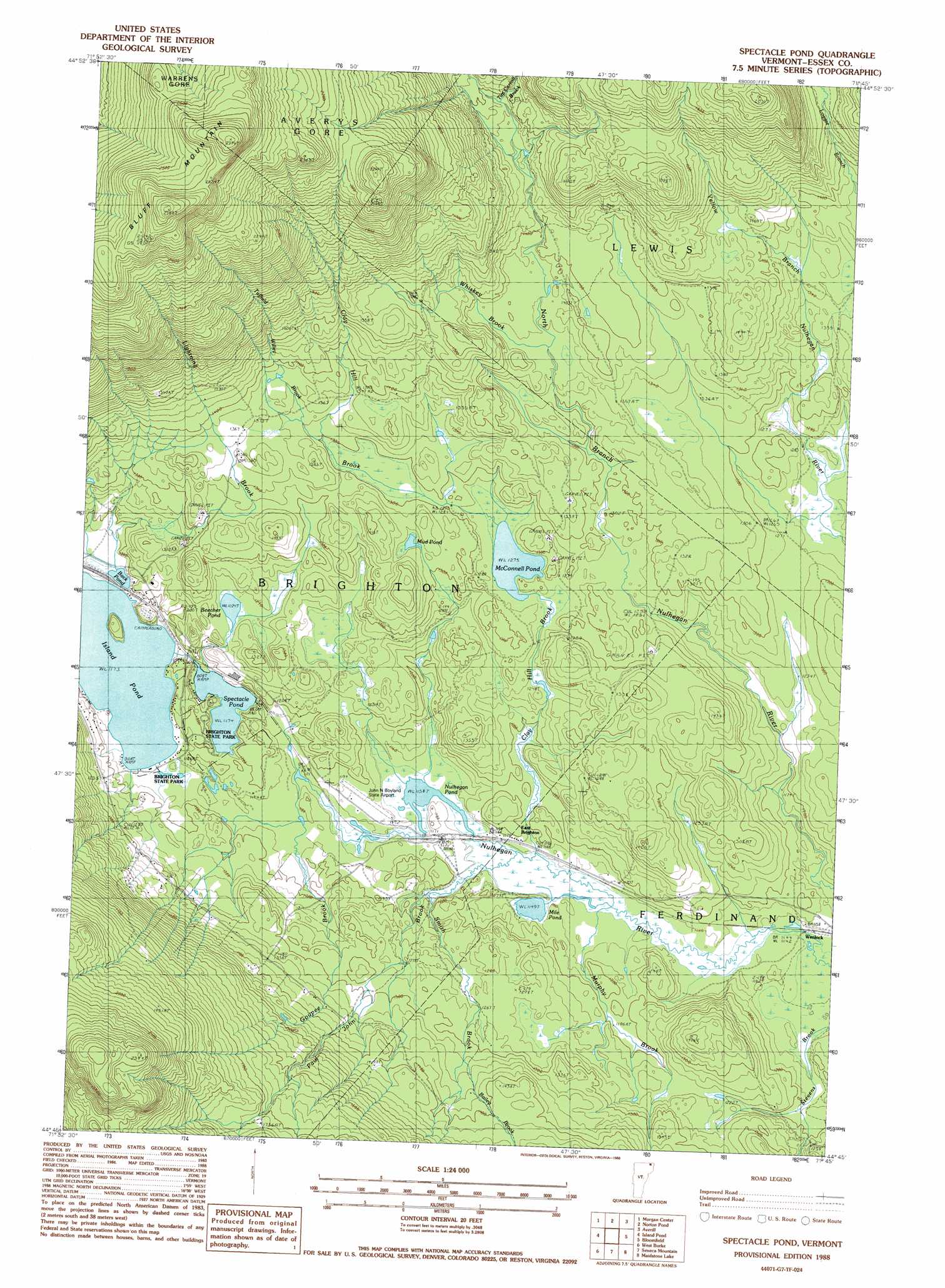
Spectacle Pond Topo Map Vermont
To zoom in, hover over the map of Spectacle Pond
USGS Topo Quad 44071g7 - 1:24,000 scale
| Topo Map Name: | Spectacle Pond |
| USGS Topo Quad ID: | 44071g7 |
| Print Size: | ca. 21 1/4" wide x 27" high |
| Southeast Coordinates: | 44.75° N latitude / 71.75° W longitude |
| Map Center Coordinates: | 44.8125° N latitude / 71.8125° W longitude |
| U.S. State: | VT |
| Filename: | o44071g7.jpg |
| Download Map JPG Image: | Spectacle Pond topo map 1:24,000 scale |
| Map Type: | Topographic |
| Topo Series: | 7.5´ |
| Map Scale: | 1:24,000 |
| Source of Map Images: | United States Geological Survey (USGS) |
| Alternate Map Versions: |
Spectacle Pond VT 1988, updated 1988 Download PDF Buy paper map Spectacle Pond VT 1988, updated 1988 Download PDF Buy paper map Spectacle Pond VT 2012 Download PDF Buy paper map Spectacle Pond VT 2015 Download PDF Buy paper map |
1:24,000 Topo Quads surrounding Spectacle Pond
West Charleston |
Morgan Center |
Norton Pond |
Averill Lake |
Monadnock Mountain |
Westmore |
Island Pond |
Spectacle Pond |
Bloomfield |
Tinkerville |
Sutton |
West Burke |
Seneca Mountain |
Maidstone Lake |
Stratford |
Lyndonville |
Burke Mountain |
Gallup Mills |
Stone Mountain |
Groveton |
> Back to 44071e1 at 1:100,000 scale
> Back to 44070a1 at 1:250,000 scale
> Back to U.S. Topo Maps home
Spectacle Pond topo map: Gazetteer
Spectacle Pond: Airports
John H Boylan State Airport elevation 352m 1154′John H Boyland State Airport elevation 362m 1187′
Wenlock Crossing Heliport elevation 355m 1164′
Spectacle Pond: Capes
Eagle Point elevation 363m 1190′Loon Point elevation 360m 1181′
Pine Point elevation 360m 1181′
Spectacle Pond: Forests
Brighton Municipal Forest elevation 430m 1410′Spectacle Pond: Lakes
Back Pond elevation 359m 1177′Beecher Pond elevation 373m 1223′
Island Pond elevation 357m 1171′
McConnell Pond elevation 389m 1276′
Mile Pond elevation 350m 1148′
Mud Pond elevation 403m 1322′
Nulhegan Pond elevation 352m 1154′
Spectacle Pond elevation 358m 1174′
Spectacle Pond: Parks
Brighton State Park elevation 358m 1174′Spectacle Pond: Populated Places
East Brighton elevation 352m 1154′Wenlock elevation 353m 1158′
Spectacle Pond: Streams
Bailey Brook elevation 354m 1161′Clay Hill Brook elevation 395m 1295′
Goupee Brook elevation 353m 1158′
Lightning Brook elevation 356m 1167′
Murphy Brook elevation 352m 1154′
Paul John Brook elevation 352m 1154′
Smith Brook elevation 387m 1269′
Tim Carroll Brook elevation 448m 1469′
Tuffield Willey Brook elevation 399m 1309′
Whiskey Brook elevation 413m 1354′
Spectacle Pond: Summits
Bluff Mountain elevation 829m 2719′Spectacle Pond: Trails
Loggers Loop Trail elevation 364m 1194′Main Trail elevation 363m 1190′
Red Pine Trail elevation 366m 1200′
Shore Trail elevation 365m 1197′
Spectacle Pond digital topo map on disk
Buy this Spectacle Pond topo map showing relief, roads, GPS coordinates and other geographical features, as a high-resolution digital map file on DVD:
Maine, New Hampshire, Rhode Island & Eastern Massachusetts
Buy digital topo maps: Maine, New Hampshire, Rhode Island & Eastern Massachusetts