Dover-Foxcroft Topo Map Maine
To zoom in, hover over the map of Dover-Foxcroft
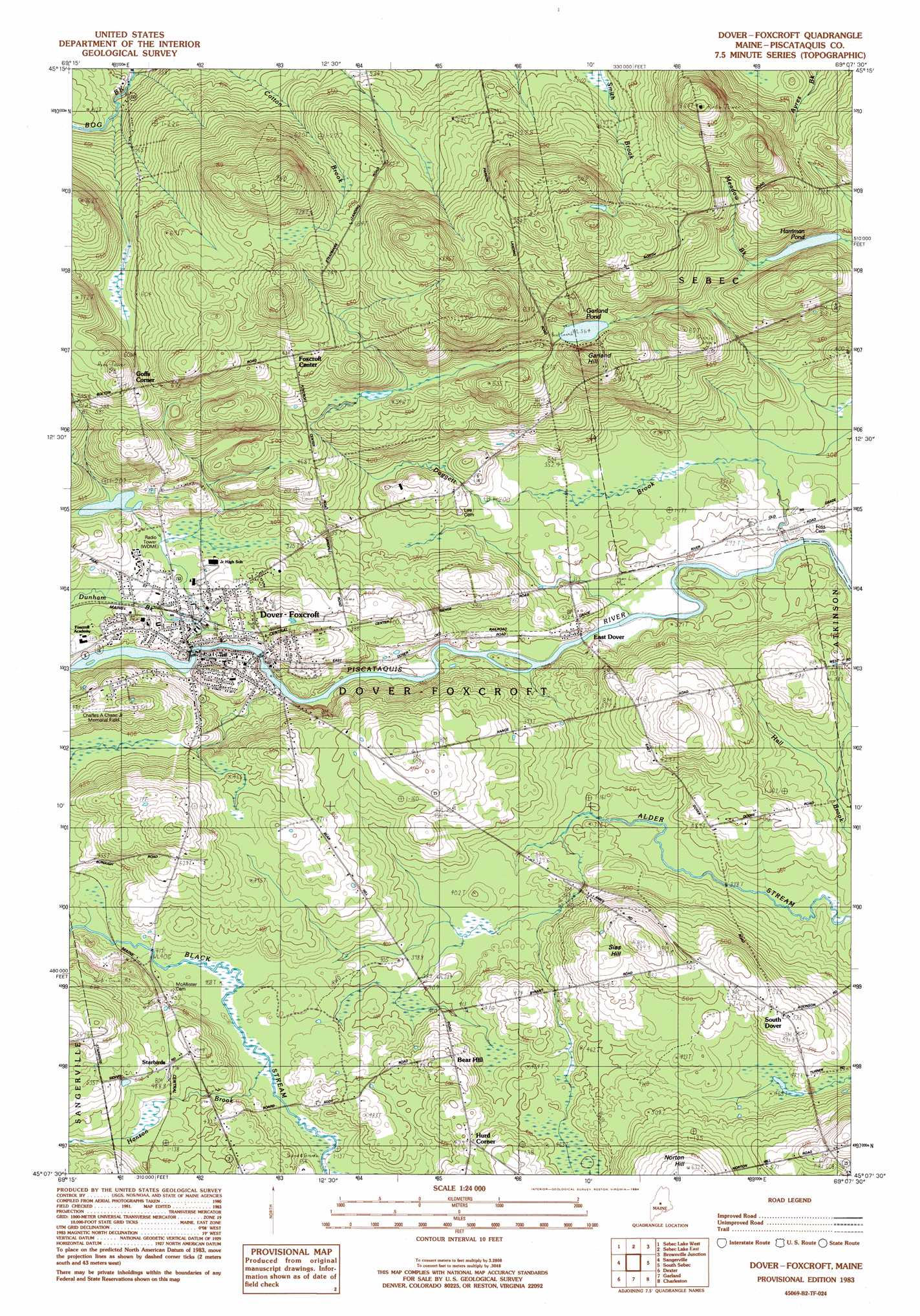
USGS Topo Quad 45069b2 - 1:24,000 scale
| Topo Map Name: | Dover-Foxcroft |
| USGS Topo Quad ID: | 45069b2 |
| Print Size: | ca. 21 1/4" wide x 27" high |
| Southeast Coordinates: | 45.125° N latitude / 69.125° W longitude |
| Map Center Coordinates: | 45.1875° N latitude / 69.1875° W longitude |
| U.S. State: | ME |
| Filename: | o45069b2.jpg |
| Download Map JPG Image: | Dover-Foxcroft topo map 1:24,000 scale |
| Map Type: | Topographic |
| Topo Series: | 7.5´ |
| Map Scale: | 1:24,000 |
| Source of Map Images: | United States Geological Survey (USGS) |
| Alternate Map Versions: |
Dover-Foxcroft NW ME 1975, updated 1980 Download PDF Buy paper map Dover-Foxcroft ME 1983, updated 1984 Download PDF Buy paper map Dover-Foxcroft ME 1983, updated 1984 Download PDF Buy paper map Dover-Foxcroft ME 2011 Download PDF Buy paper map Dover-Foxcroft ME 2014 Download PDF Buy paper map |
1:24,000 Topo Quads surrounding Dover-Foxcroft
Barren Mountain West |
Barren Mountain East |
Silver Lake |
Ebeemee Mountain |
Seboeis Lake |
Monson East |
Sebec Lake West |
Sebec Lake East |
Brownville Junction |
Milo North |
Guilford |
Sangerville |
Dover-Foxcroft |
South Sebec |
Milo South |
Cambridge |
Dexter |
Garland |
Charleston |
Bradford |
Hartland |
Corinna |
Stetson |
West Corinth |
Kenduskeag |
> Back to 45069a1 at 1:100,000 scale
> Back to 45068a1 at 1:250,000 scale
> Back to U.S. Topo Maps home
Dover-Foxcroft topo map: Gazetteer
Dover-Foxcroft: Airports
Charles A Chase Junior Memorial Field elevation 151m 495′Riverside Seaplane Base elevation 104m 341′
Dover-Foxcroft: Dams
Lower Dam elevation 111m 364′Upper Dam elevation 104m 341′
Dover-Foxcroft: Lakes
Garland Pond elevation 172m 564′Harriman Pond elevation 153m 501′
Dover-Foxcroft: Parks
Kiwanis Park elevation 110m 360′Dover-Foxcroft: Populated Places
Dover-Foxcroft elevation 110m 360′East Dover elevation 98m 321′
Goffs Corner elevation 197m 646′
Hurd Corner elevation 147m 482′
South Dover elevation 160m 524′
Starbirds elevation 149m 488′
Dover-Foxcroft: Reservoirs
Piscataquis River Reservoir elevation 111m 364′Piscataquis River Reservoir elevation 104m 341′
Dover-Foxcroft: Streams
Daggett Brook elevation 92m 301′Dunham Brook elevation 102m 334′
Hanson Brook elevation 124m 406′
Dover-Foxcroft: Summits
Garland Hill elevation 211m 692′Dover-Foxcroft digital topo map on disk
Buy this Dover-Foxcroft topo map showing relief, roads, GPS coordinates and other geographical features, as a high-resolution digital map file on DVD:
Maine, New Hampshire, Rhode Island & Eastern Massachusetts
Buy digital topo maps: Maine, New Hampshire, Rhode Island & Eastern Massachusetts