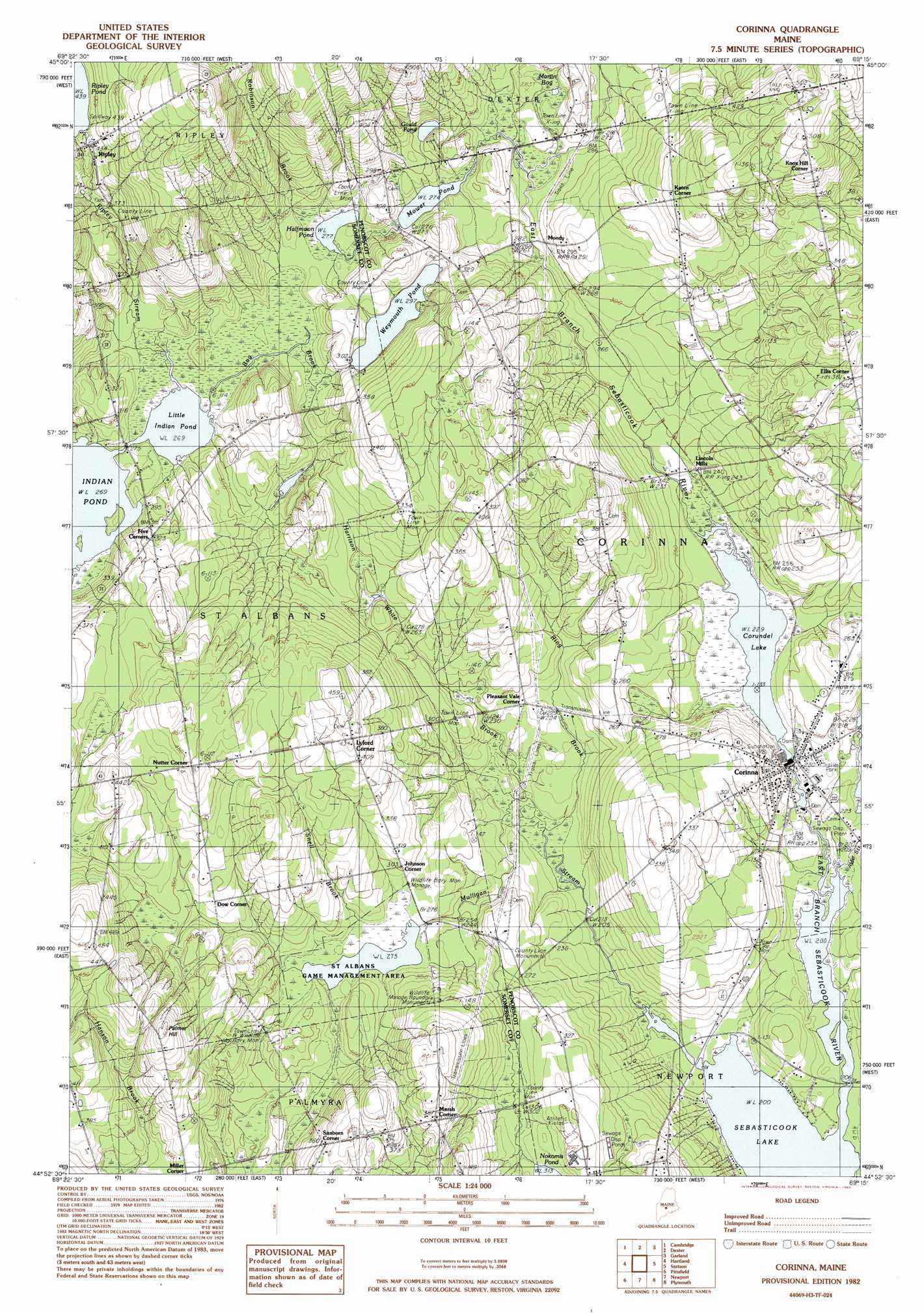
Corinna Topo Map Maine
To zoom in, hover over the map of Corinna
USGS Topo Quad 44069h3 - 1:24,000 scale
| Topo Map Name: | Corinna |
| USGS Topo Quad ID: | 44069h3 |
| Print Size: | ca. 21 1/4" wide x 27" high |
| Southeast Coordinates: | 44.875° N latitude / 69.25° W longitude |
| Map Center Coordinates: | 44.9375° N latitude / 69.3125° W longitude |
| U.S. State: | ME |
| Filename: | o44069h3.jpg |
| Download Map JPG Image: | Corinna topo map 1:24,000 scale |
| Map Type: | Topographic |
| Topo Series: | 7.5´ |
| Map Scale: | 1:24,000 |
| Source of Map Images: | United States Geological Survey (USGS) |
| Alternate Map Versions: |
Pittsfield NE ME 1975, updated 1980 Download PDF Buy paper map Corinna ME 1982, updated 1983 Download PDF Buy paper map Corinna ME 2011 Download PDF Buy paper map Corinna ME 2014 Download PDF Buy paper map |
1:24,000 Topo Quads surrounding Corinna
Whetstone Pond |
Guilford |
Sangerville |
Dover-Foxcroft |
South Sebec |
Wellington |
Cambridge |
Dexter |
Garland |
Charleston |
Harmony |
Hartland |
Corinna |
Stetson |
West Corinth |
Canaan |
Pittsfield |
Newport |
Plymouth |
Carmel |
Clinton |
Burnham |
Unity Pond |
Dixmont |
East Dixmont |
> Back to 44069e1 at 1:100,000 scale
> Back to 44068a1 at 1:250,000 scale
> Back to U.S. Topo Maps home
Corinna topo map: Gazetteer
Corinna: Dams
Lower Dam elevation 66m 216′Middle Dam elevation 69m 226′
Mulligan Stream Dam elevation 83m 272′
Ripley Pond Dam elevation 134m 439′
Upper Dam elevation 70m 229′
Weymouth Pond Dam elevation 90m 295′
Corinna: Lakes
Gould Pond elevation 90m 295′Halfmoon Pond elevation 84m 275′
Little Indian Pond elevation 82m 269′
Mower Pond elevation 83m 272′
Corinna: Parks
Saint Albans Game Management Area elevation 83m 272′Corinna: Populated Places
Corinna elevation 70m 229′Dixie Corner elevation 107m 351′
Dow Corner elevation 105m 344′
Ellis Corner elevation 113m 370′
Johnson Corner elevation 92m 301′
Katen Corner elevation 125m 410′
Knox Hill Corner elevation 148m 485′
Lincoln Mills elevation 73m 239′
Lyford Corner elevation 133m 436′
Marsh Corner elevation 117m 383′
Miller Corner elevation 110m 360′
Moody elevation 86m 282′
Nutter Corner elevation 136m 446′
Pleasant Vale Corner elevation 72m 236′
Ripley elevation 133m 436′
Sanborn Corner elevation 109m 357′
Corinna: Reservoirs
East Branch Sebasticook River Reservoir elevation 70m 229′East Branch Sebasticook River Reservoir elevation 69m 226′
East Branch Sebasticook River Reservoir elevation 66m 216′
Mulligan Stream elevation 83m 272′
Ripley Pond elevation 134m 439′
Weymouth Pond elevation 90m 295′
Corinna: Streams
Addition Brook elevation 112m 367′Alder Stream elevation 61m 200′
Bog Brook elevation 82m 269′
Harrison White Brook elevation 62m 203′
Mulligan Stream elevation 61m 200′
Ring Brook elevation 62m 203′
Ripley Stream elevation 84m 275′
Robinson Brook elevation 85m 278′
Snell Brook elevation 83m 272′
Corinna: Summits
Palmer Hill elevation 153m 501′Corinna: Swamps
Martin Bog elevation 85m 278′Corinna digital topo map on disk
Buy this Corinna topo map showing relief, roads, GPS coordinates and other geographical features, as a high-resolution digital map file on DVD:
Maine, New Hampshire, Rhode Island & Eastern Massachusetts
Buy digital topo maps: Maine, New Hampshire, Rhode Island & Eastern Massachusetts