Summerville Topo Map Oregon
To zoom in, hover over the map of Summerville
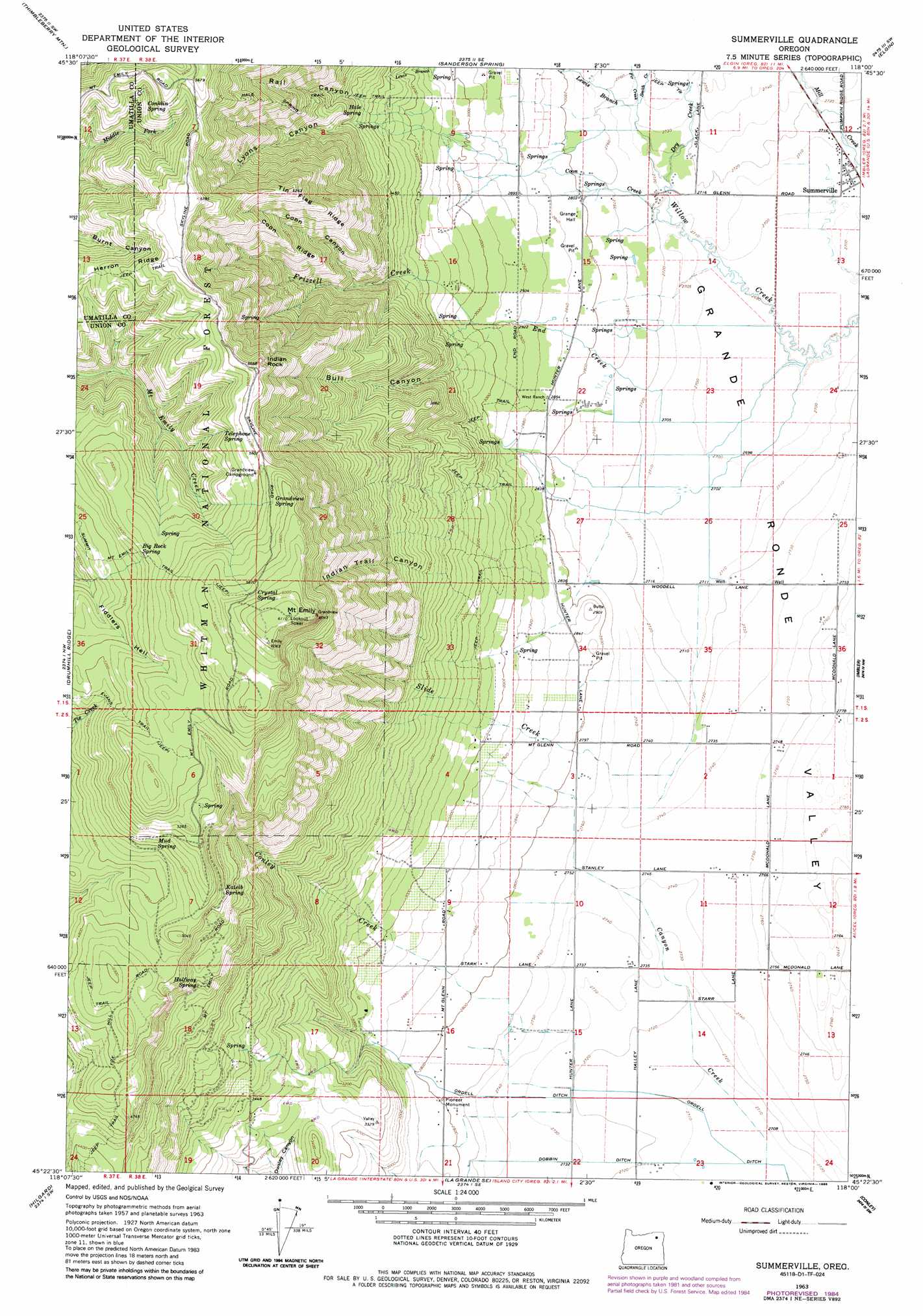
USGS Topo Quad 45118d1 - 1:24,000 scale
| Topo Map Name: | Summerville |
| USGS Topo Quad ID: | 45118d1 |
| Print Size: | ca. 21 1/4" wide x 27" high |
| Southeast Coordinates: | 45.375° N latitude / 118° W longitude |
| Map Center Coordinates: | 45.4375° N latitude / 118.0625° W longitude |
| U.S. State: | OR |
| Filename: | o45118d1.jpg |
| Download Map JPG Image: | Summerville topo map 1:24,000 scale |
| Map Type: | Topographic |
| Topo Series: | 7.5´ |
| Map Scale: | 1:24,000 |
| Source of Map Images: | United States Geological Survey (USGS) |
| Alternate Map Versions: |
Summerville OR 1963, updated 1966 Download PDF Buy paper map Summerville OR 1963, updated 1985 Download PDF Buy paper map Summerville OR 1996, updated 1998 Download PDF Buy paper map Summerville OR 2011 Download PDF Buy paper map Summerville OR 2014 Download PDF Buy paper map |
| FStopo: | US Forest Service topo Summerville is available: Download FStopo PDF Download FStopo TIF |
1:24,000 Topo Quads surrounding Summerville
Gibbon |
Bingham Springs |
Andies Prairie |
Partridge Creek |
Rondowa |
Duncan |
Thimbleberry Mountain |
Sanderson Spring |
Elgin |
Cricket Flat |
Huron |
Drumhill Ridge |
Summerville |
Imbler |
Gassett Bluff |
Kamela Se |
Hilgard |
La Grande |
Conley |
Cove |
Little Beaver Creek |
La Grande Reservoir |
Glass Hill |
Craig Mountain |
Union |
> Back to 45118a1 at 1:100,000 scale
> Back to 45118a1 at 1:250,000 scale
> Back to U.S. Topo Maps home
Summerville topo map: Gazetteer
Summerville: Canals
Ordell Ditch elevation 827m 2713′Summerville: Parks
Pioneer Monument elevation 855m 2805′Summerville: Pillars
Indian Rock elevation 1707m 5600′Summerville: Populated Places
Summerville elevation 825m 2706′Summerville: Post Offices
Summerville Post Office elevation 825m 2706′Summerville: Reservoirs
Starr Reservoir elevation 867m 2844′Wrights Reservoirs elevation 842m 2762′
York Reservoir elevation 839m 2752′
Summerville: Ridges
Coon Ridge elevation 1450m 4757′Tin Flag Ridge elevation 1600m 5249′
Summerville: Springs
Big Rock Spring elevation 1634m 5360′Conklin Spring elevation 1687m 5534′
Crystal Spring elevation 1798m 5898′
Grandview Spring elevation 1729m 5672′
Hale Spring elevation 1083m 3553′
Halfway Spring elevation 1326m 4350′
Kaleib Spring elevation 1505m 4937′
Mayville Spring elevation 1462m 4796′
Mint Spring elevation 958m 3143′
Mud Spring elevation 1514m 4967′
Telephone Spring elevation 1677m 5501′
Summerville: Streams
Canyon Creek elevation 824m 2703′Conley Creek elevation 830m 2723′
Coon Creek elevation 825m 2706′
Dry Creek elevation 827m 2713′
End Creek elevation 828m 2716′
Fir Creek elevation 836m 2742′
Frizzell Creek elevation 916m 3005′
Hacker Creek elevation 839m 2752′
Lewis Branch elevation 858m 2814′
Slide Creek elevation 826m 2709′
Smith Creek elevation 836m 2742′
South Fork Willow Creek (historical) elevation 821m 2693′
Waite Creek elevation 830m 2723′
Summerville: Summits
Blue Mountains elevation 833m 2732′Mount Emily elevation 1859m 6099′
Summerville: Trails
Evans Trail elevation 1609m 5278′Hale Spring Trail elevation 1478m 4849′
Summerville: Valleys
Bull Canyon elevation 907m 2975′Coon Canyon elevation 1081m 3546′
Hunter Canyon elevation 888m 2913′
Indian Trail Canyon elevation 1053m 3454′
Lyons Canyon elevation 1090m 3576′
Rail Canyon elevation 981m 3218′
Summerville digital topo map on disk
Buy this Summerville topo map showing relief, roads, GPS coordinates and other geographical features, as a high-resolution digital map file on DVD: