Cathlamet Bay Topo Map Oregon
To zoom in, hover over the map of Cathlamet Bay
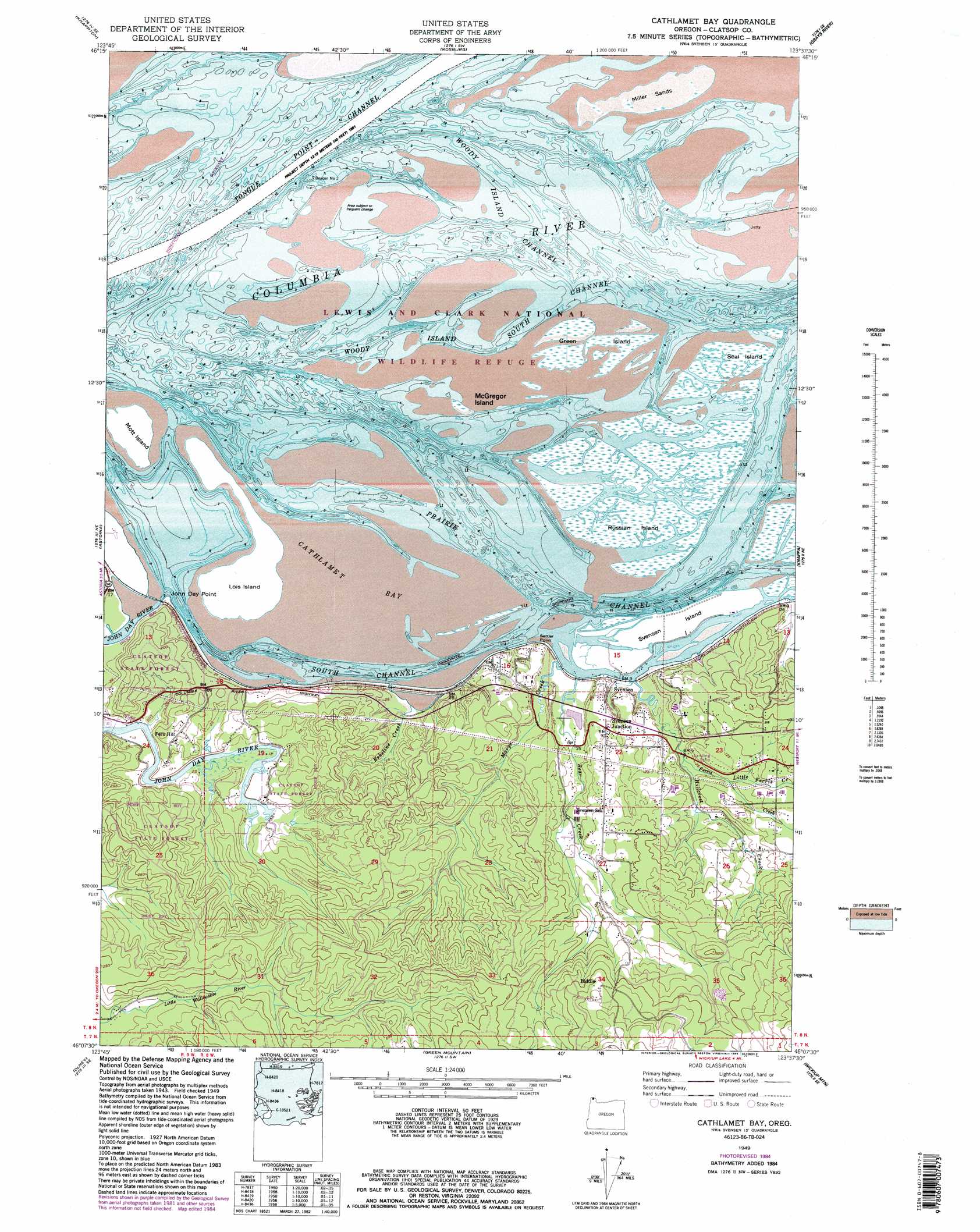
USGS Topo Quad 46123b6 - 1:24,000 scale
| Topo Map Name: | Cathlamet Bay |
| USGS Topo Quad ID: | 46123b6 |
| Print Size: | ca. 21 1/4" wide x 27" high |
| Southeast Coordinates: | 46.125° N latitude / 123.625° W longitude |
| Map Center Coordinates: | 46.1875° N latitude / 123.6875° W longitude |
| U.S. State: | OR |
| Filename: | o46123b6.jpg |
| Download Map JPG Image: | Cathlamet Bay topo map 1:24,000 scale |
| Map Type: | Topographic |
| Topo Series: | 7.5´ |
| Map Scale: | 1:24,000 |
| Source of Map Images: | United States Geological Survey (USGS) |
| Alternate Map Versions: |
Cathlamet Bay OR 1949, updated 1955 Download PDF Buy paper map Cathlamet Bay OR 1949, updated 1967 Download PDF Buy paper map Cathlamet Bay OR 1949, updated 1977 Download PDF Buy paper map Cathlamet Bay OR 1949, updated 1985 Download PDF Buy paper map Cathlamet Bay OR 2011 Download PDF Buy paper map Cathlamet Bay OR 2014 Download PDF Buy paper map |
1:24,000 Topo Quads surrounding Cathlamet Bay
Long Island |
Oman Ranch |
Upper Naselle River |
Sweigiler Creek |
Blaney Creek |
Chinook |
Knappton |
Rosburg |
Grays River |
Skamokawa |
Warrenton |
Astoria |
Cathlamet Bay |
Knappa |
Cathlamet |
Gearhart |
Olney |
Green Mountain |
Wickiup Mountain |
Nicolai Mountain |
Tillamook Head |
Necanicum Junction |
Saddle Mountain |
Vinemaple |
Sager Creek |
> Back to 46123a1 at 1:100,000 scale
> Back to 46122a1 at 1:250,000 scale
> Back to U.S. Topo Maps home
Cathlamet Bay topo map: Gazetteer
Cathlamet Bay: Airports
Karpens Airstrip elevation 10m 32′Cathlamet Bay: Bays
Cathlamet Bay elevation 0m 0′Cathlamet Bay: Capes
John Day Point elevation 2m 6′Settler Point elevation 19m 62′
Cathlamet Bay: Channels
Harrington Point Range elevation 0m 0′John Day Channel elevation 0m 0′
North Channel elevation 0m 0′
Prairie Channel elevation 0m 0′
South Channel elevation 0m 0′
Woody Island Channel elevation 0m 0′
Cathlamet Bay: Islands
Grassy Island elevation 0m 0′Green Island elevation 2m 6′
Lois Island elevation 2m 6′
McGregor Island elevation 0m 0′
Miller Sands elevation 2m 6′
Mott Island elevation 2m 6′
North Island elevation 0m 0′
Russian Island elevation 2m 6′
Seal Island elevation 1m 3′
Svensen Island elevation 2m 6′
Cathlamet Bay: Parks
John Day County Park elevation 61m 200′Lewis and Clark National Wildlife Refuge elevation 0m 0′
Cathlamet Bay: Populated Places
Biddle (historical) elevation 172m 564′Burnside (historical) elevation 2m 6′
Fern Hill elevation 42m 137′
Svensen elevation 9m 29′
Svensen Junction elevation 26m 85′
Cathlamet Bay: Post Offices
Fern Hill Post Office (historical) elevation 42m 137′Svensen Post Office (historical) elevation 9m 29′
Cathlamet Bay: Streams
Bear Creek elevation 1m 3′Big Creek Slough elevation 0m 0′
Calendar Slough elevation 0m 0′
Davis Creek elevation 0m 0′
Eskeline Creek elevation 1m 3′
Ferris Creek elevation 10m 32′
Hillcrest Creek elevation 2m 6′
Little Bear Creek elevation 16m 52′
Little Ferris Creek elevation 14m 45′
Marys Creek elevation -2m -7′
Rock Creek elevation 28m 91′
Spear Creek elevation 0m 0′
Svensen Slough elevation 0m 0′
Cathlamet Bay digital topo map on disk
Buy this Cathlamet Bay topo map showing relief, roads, GPS coordinates and other geographical features, as a high-resolution digital map file on DVD: