Hay Coulee Topo Map Montana
To zoom in, hover over the map of Hay Coulee
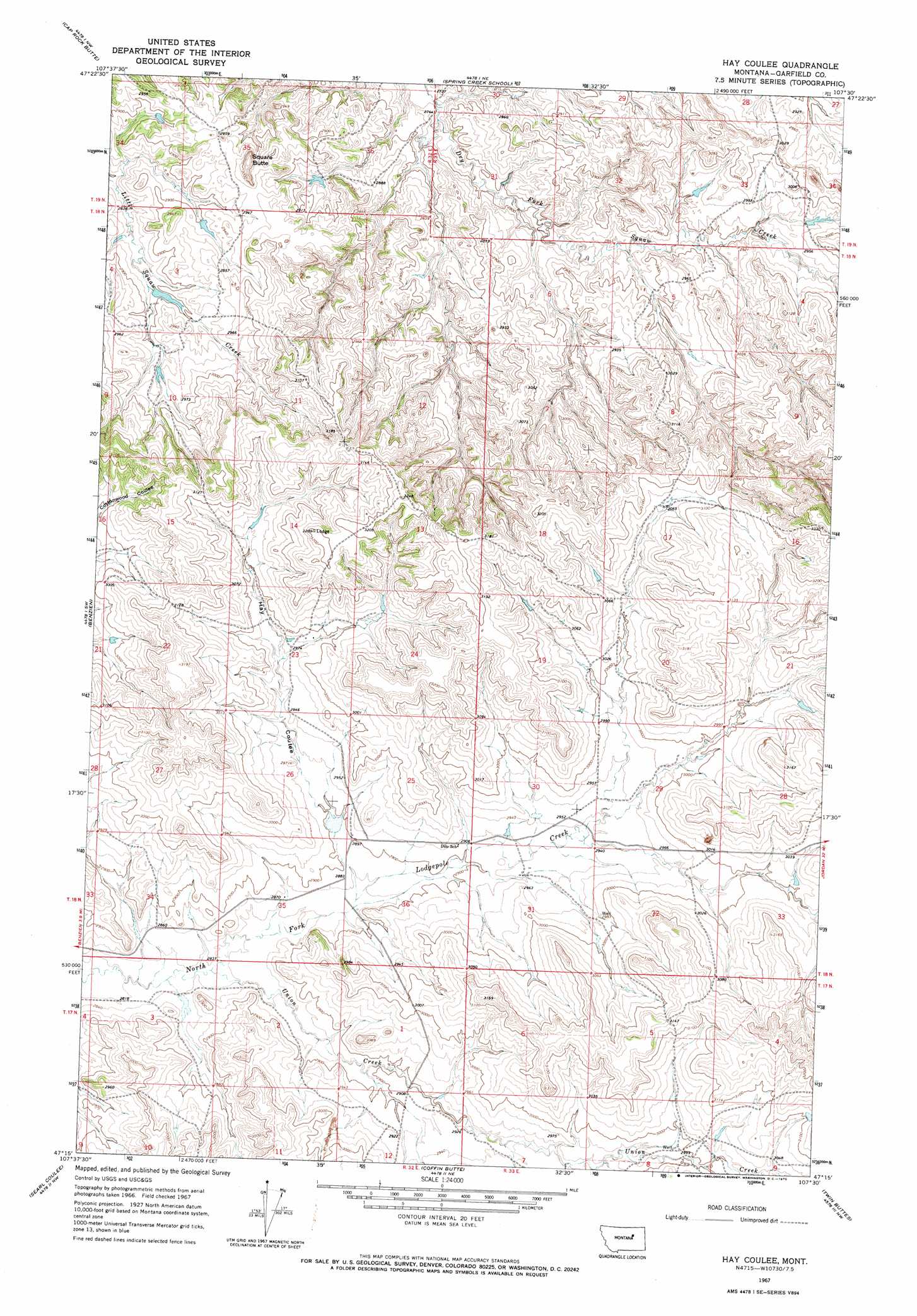
USGS Topo Quad 47107c5 - 1:24,000 scale
| Topo Map Name: | Hay Coulee |
| USGS Topo Quad ID: | 47107c5 |
| Print Size: | ca. 21 1/4" wide x 27" high |
| Southeast Coordinates: | 47.25° N latitude / 107.5° W longitude |
| Map Center Coordinates: | 47.3125° N latitude / 107.5625° W longitude |
| U.S. State: | MT |
| Filename: | o47107c5.jpg |
| Download Map JPG Image: | Hay Coulee topo map 1:24,000 scale |
| Map Type: | Topographic |
| Topo Series: | 7.5´ |
| Map Scale: | 1:24,000 |
| Source of Map Images: | United States Geological Survey (USGS) |
| Alternate Map Versions: |
Hay Coulee MT 1967, updated 1970 Download PDF Buy paper map Hay Coulee MT 2011 Download PDF Buy paper map Hay Coulee MT 2014 Download PDF Buy paper map |
1:24,000 Topo Quads surrounding Hay Coulee
Mickey Butte |
Lost Creek |
Pine Grove School |
Sawmill Creek |
Chalk Butte |
Germaine Coulee East |
Cap Rock Butte |
Spring Creek School |
Blackfoot School |
Brusett |
Seventynine Coulee |
Benzien |
Hay Coulee |
Steve Forks Sw |
Steve Forks |
Lelig Coulee |
Searl Coulee |
Coffin Butte |
Twin Buttes |
Edwards |
Barney Pinnacle |
Froehlich Butte |
Cox Butte |
Sand Springs |
Robertson School |
> Back to 47107a1 at 1:100,000 scale
> Back to 47106a1 at 1:250,000 scale
> Back to U.S. Topo Maps home
Hay Coulee topo map: Gazetteer
Hay Coulee: Dams
Haypense Dam elevation 882m 2893′Pense Reservoir Dam elevation 895m 2936′
Hay Coulee: Post Offices
Dilo Post Office (historical) elevation 890m 2919′Hay Coulee: Streams
Union Creek elevation 868m 2847′Hay Coulee: Summits
Square Butte elevation 931m 3054′Hay Coulee: Valleys
Hay Coulee elevation 886m 2906′Hay Coulee: Wells
18N32E25CCCC01 Well elevation 891m 2923′Hay Coulee digital topo map on disk
Buy this Hay Coulee topo map showing relief, roads, GPS coordinates and other geographical features, as a high-resolution digital map file on DVD:
Eastern Montana & Western North Dakota
Buy digital topo maps: Eastern Montana & Western North Dakota