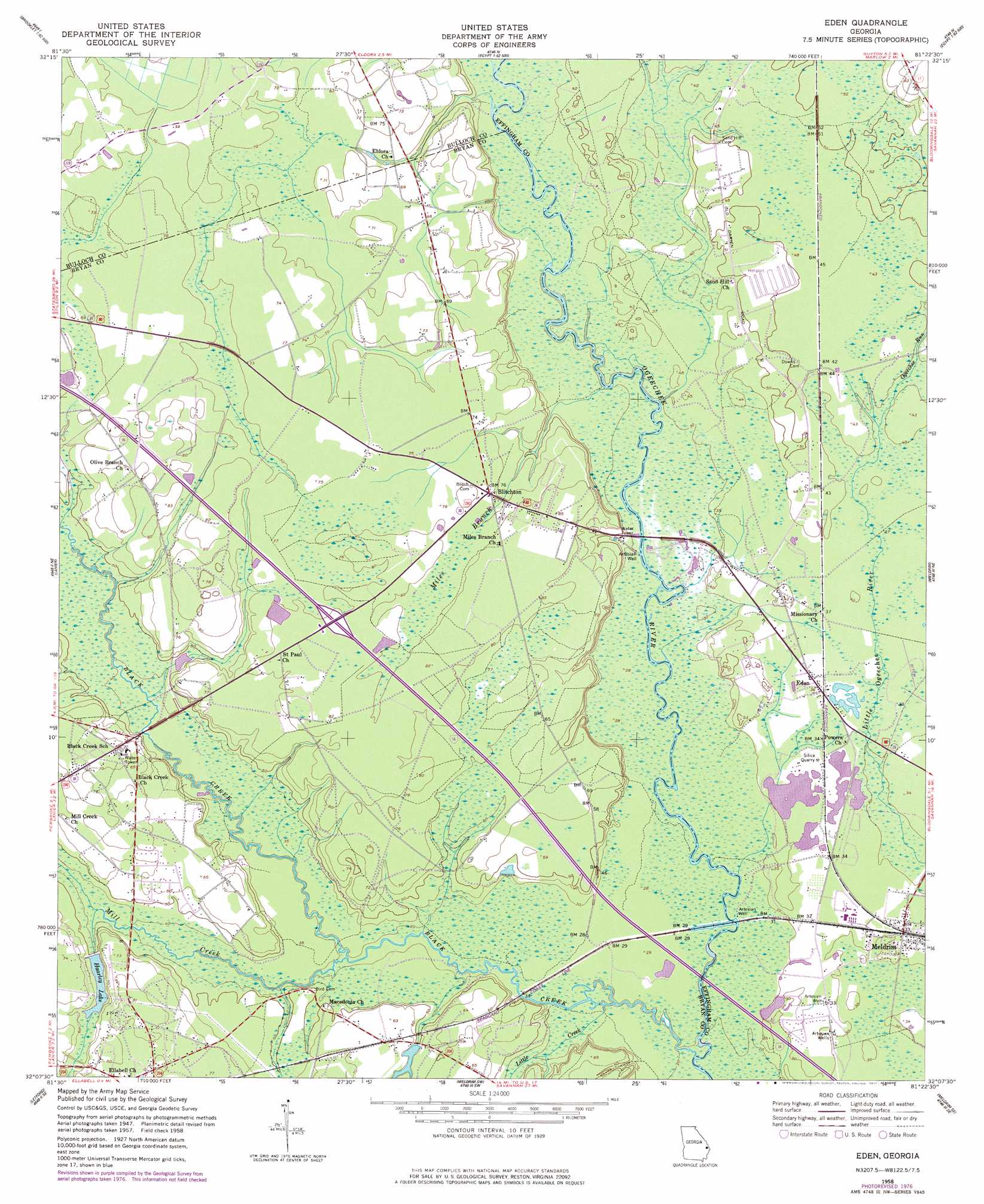
Eden Topo Map Georgia
To zoom in, hover over the map of Eden
USGS Topo Quad 32081b4 - 1:24,000 scale
| Topo Map Name: | Eden |
| USGS Topo Quad ID: | 32081b4 |
| Print Size: | ca. 21 1/4" wide x 27" high |
| Southeast Coordinates: | 32.125° N latitude / 81.375° W longitude |
| Map Center Coordinates: | 32.1875° N latitude / 81.4375° W longitude |
| U.S. State: | GA |
| Filename: | o32081b4.jpg |
| Download Map JPG Image: | Eden topo map 1:24,000 scale |
| Map Type: | Topographic |
| Topo Series: | 7.5´ |
| Map Scale: | 1:24,000 |
| Source of Map Images: | United States Geological Survey (USGS) |
| Alternate Map Versions: |
Eden GA 1958, updated 1961 Download PDF Buy paper map Eden GA 1958, updated 1977 Download PDF Buy paper map Eden GA 2011 Download PDF Buy paper map Eden GA 2014 Download PDF Buy paper map |
1:24,000 Topo Quads surrounding Eden
Brooklet |
Leefield |
Egypt |
Springfield North |
Hardeeville Nw |
Denmark |
Stilson |
Guyton |
Springfield South |
Rincon |
Groveland |
Lanier |
Eden |
Meldrim |
Port Wentworth |
Willie |
Letford |
Meldrim Sw |
Meldrim Se |
Garden City |
Taylors Creek |
Trinity |
Limerick Nw |
Richmond Hill |
Burroughs |
> Back to 32081a1 at 1:100,000 scale
> Back to 32080a1 at 1:250,000 scale
> Back to U.S. Topo Maps home
Eden topo map: Gazetteer
Eden: Crossings
Exit 29 elevation 24m 78′Eden: Dams
Lake Lorraine Dam elevation 15m 49′Eden: Populated Places
Black Creek elevation 18m 59′Blitchton elevation 22m 72′
Doswell elevation 15m 49′
Eden elevation 10m 32′
Meldrim elevation 9m 29′
Eden: Post Offices
Eden Post Office elevation 10m 32′Ellabell Post Office elevation 21m 68′
Meldrim Post Office elevation 9m 29′
Eden: Reservoirs
Haarley Lake elevation 16m 52′Eden: Streams
Black Creek elevation 5m 16′Little Creek elevation 6m 19′
Miles Branch elevation 9m 29′
Mill Creek elevation 7m 22′
Ogeechee Run elevation 11m 36′
Eden digital topo map on disk
Buy this Eden topo map showing relief, roads, GPS coordinates and other geographical features, as a high-resolution digital map file on DVD:
South Carolina, Western North Carolina & Northeastern Georgia
Buy digital topo maps: South Carolina, Western North Carolina & Northeastern Georgia