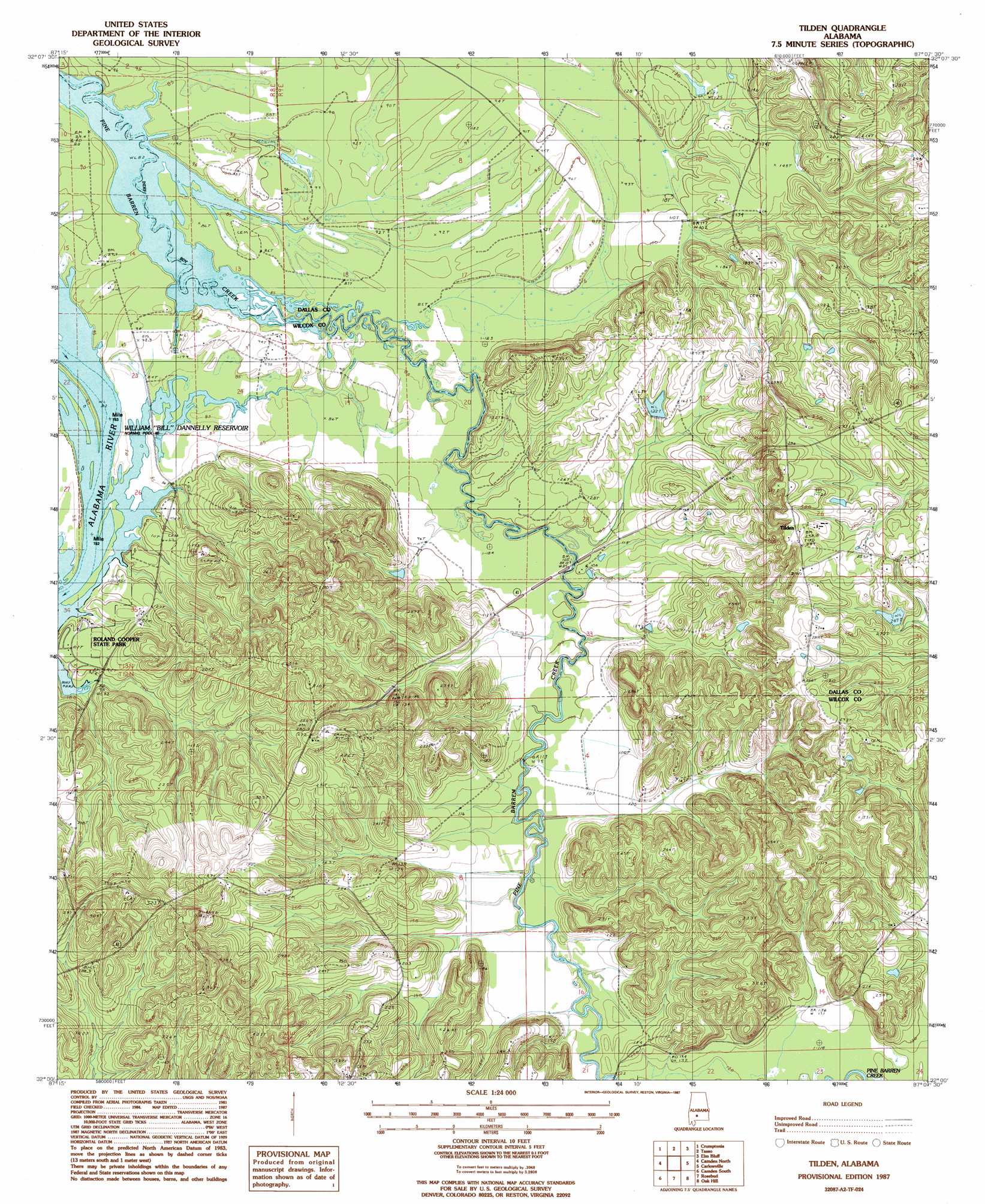
Tilden Topo Map Alabama
To zoom in, hover over the map of Tilden
USGS Topo Quad 32087a2 - 1:24,000 scale
| Topo Map Name: | Tilden |
| USGS Topo Quad ID: | 32087a2 |
| Print Size: | ca. 21 1/4" wide x 27" high |
| Southeast Coordinates: | 32° N latitude / 87.125° W longitude |
| Map Center Coordinates: | 32.0625° N latitude / 87.1875° W longitude |
| U.S. State: | AL |
| Filename: | o32087a2.jpg |
| Download Map JPG Image: | Tilden topo map 1:24,000 scale |
| Map Type: | Topographic |
| Topo Series: | 7.5´ |
| Map Scale: | 1:24,000 |
| Source of Map Images: | United States Geological Survey (USGS) |
| Alternate Map Versions: |
Tilden AL 1987, updated 1987 Download PDF Buy paper map Tilden AL 2011 Download PDF Buy paper map Tilden AL 2014 Download PDF Buy paper map |
1:24,000 Topo Quads surrounding Tilden
Central Mills |
Safford |
Orrville |
Blackwell Bend |
Sardis |
Catherine |
Crumptonia |
Tasso |
Elm Bluff |
Pleasant Hill |
Lee Long Bridge |
Camden North |
Tilden |
Carlowville |
Minter |
Coy |
Camden South |
Rosebud |
Oak Hill |
Pine Apple North |
Hybart |
Vredenburgh |
Nadawah |
Mcwilliams |
Pine Apple South |
> Back to 32087a1 at 1:100,000 scale
> Back to 32086a1 at 1:250,000 scale
> Back to U.S. Topo Maps home
Tilden topo map: Gazetteer
Tilden: Bars
Saint John Bar elevation 24m 78′Tilden: Cliffs
Hurricane Bluff elevation 24m 78′Tilden: Dams
Choctaw County School Lake Dam elevation 25m 82′Frank Cothran Dam elevation 63m 206′
US Steel Lake Dam elevation 37m 121′
Tilden: Parks
Roland Cooper State Park elevation 24m 78′Tilden: Populated Places
Tilden elevation 88m 288′Tilden: Reservoirs
Choctaw County School Lake elevation 25m 82′Frank Cothran Lake elevation 63m 206′
US Steel Lake elevation 37m 121′
Tilden digital topo map on disk
Buy this Tilden topo map showing relief, roads, GPS coordinates and other geographical features, as a high-resolution digital map file on DVD:
Gulf Coast (LA, MS, AL, FL) & Southwestern Georgia
Buy digital topo maps: Gulf Coast (LA, MS, AL, FL) & Southwestern Georgia
 & Southwestern Georgia map DVD")