Gilliam Topo Map Louisiana
To zoom in, hover over the map of Gilliam
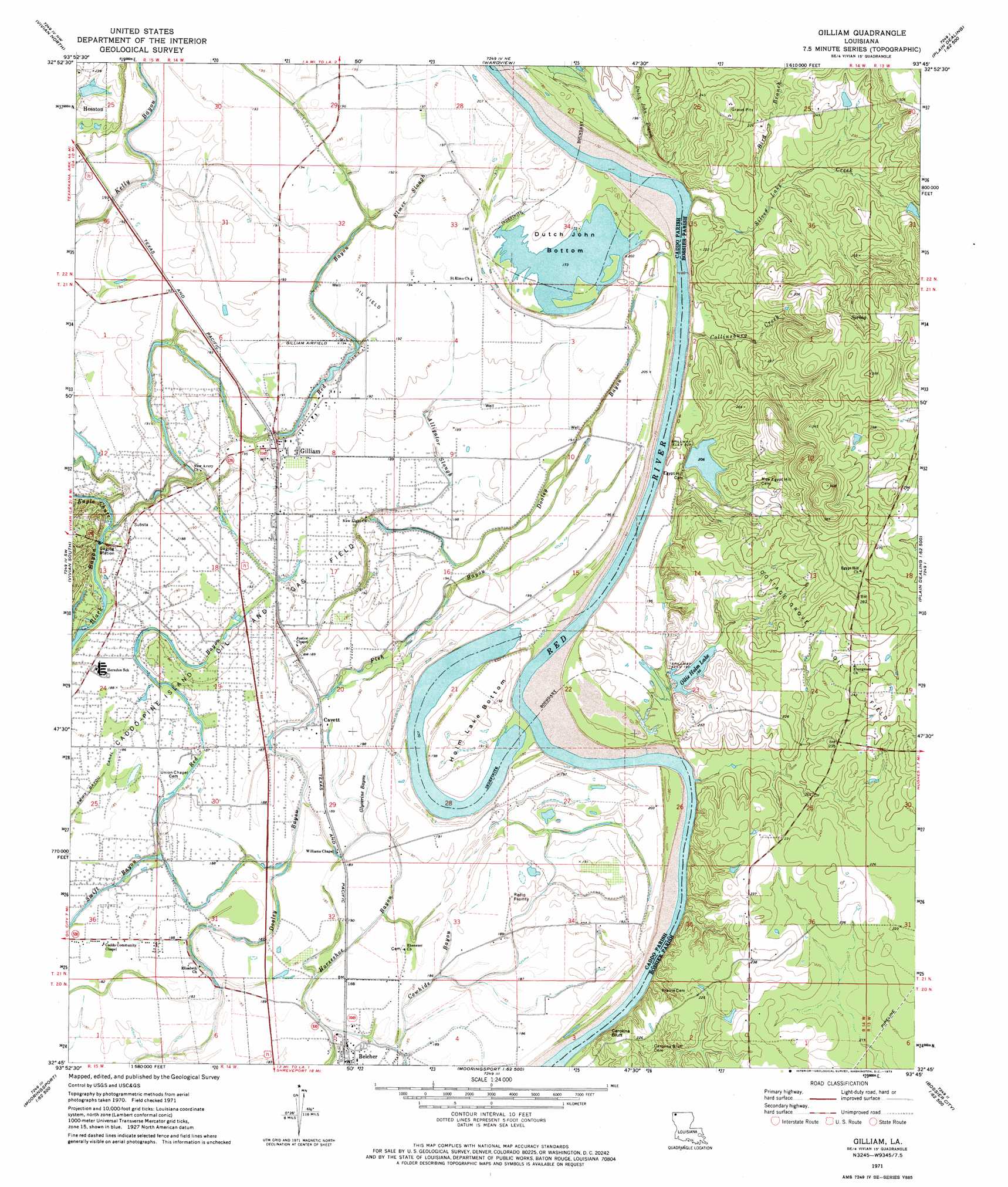
USGS Topo Quad 32093g7 - 1:24,000 scale
| Topo Map Name: | Gilliam |
| USGS Topo Quad ID: | 32093g7 |
| Print Size: | ca. 21 1/4" wide x 27" high |
| Southeast Coordinates: | 32.75° N latitude / 93.75° W longitude |
| Map Center Coordinates: | 32.8125° N latitude / 93.8125° W longitude |
| U.S. State: | LA |
| Filename: | o32093g7.jpg |
| Download Map JPG Image: | Gilliam topo map 1:24,000 scale |
| Map Type: | Topographic |
| Topo Series: | 7.5´ |
| Map Scale: | 1:24,000 |
| Source of Map Images: | United States Geological Survey (USGS) |
| Alternate Map Versions: |
Gilliam LA 1971, updated 1973 Download PDF Buy paper map Gilliam LA 2012 Download PDF Buy paper map Gilliam LA 2015 Download PDF Buy paper map |
1:24,000 Topo Quads surrounding Gilliam
Ravanna |
Doddridge |
Doddridge Se |
Bradley |
Bradley Se |
Mcleod |
Vivian North |
Wardview |
Plain Dealing |
Carterville |
Trees |
Vivian South |
Gilliam |
Hughes |
Ivan |
Potters Point |
Mooringsport |
Dixie |
Benton |
Bodcau Lake |
Latex |
Blanchard |
North Highlands |
Bossier City |
Eastwood |
> Back to 32093e1 at 1:100,000 scale
> Back to 32092a1 at 1:250,000 scale
> Back to U.S. Topo Maps home
Gilliam topo map: Gazetteer
Gilliam: Airports
Gilliam Airport elevation 59m 193′Gilliam: Bends
Dutch John Bottom elevation 54m 177′Holm Lake Bottom elevation 57m 187′
Gilliam: Cliffs
Carolina Bluff elevation 53m 173′Cedar Bluffs elevation 64m 209′
Coushatta Bluffs elevation 72m 236′
Irvings Bluff elevation 59m 193′
Gilliam: Crossings
Gilmer Ferry (historical) elevation 54m 177′Peru Ferry (historical) elevation 48m 157′
Pine Bluff Ferry (historical) elevation 53m 173′
Rush Point Ferry (historical) elevation 47m 154′
Gilliam: Dams
Ollie Holm Lake Dam elevation 60m 196′Gilliam: Lakes
Dutch Johns Lake elevation 53m 173′Macks Lake (historical) elevation 49m 160′
Gilliam: Oilfields
Cottage Grove Oil and Gas Field elevation 67m 219′Gilliam: Populated Places
Cavett elevation 57m 187′Gilliam elevation 59m 193′
Lane (historical) elevation 58m 190′
Gilliam: Reservoirs
Ollie Holm Lake elevation 60m 196′Gilliam: Streams
Alligator Slough elevation 58m 190′Bird Branch elevation 59m 193′
Collinsburg Creek elevation 48m 157′
Dutch John Branch elevation 53m 173′
Elmer Slough elevation 55m 180′
Fish Bayou elevation 55m 180′
Glycerine Bayou elevation 56m 183′
Red Bayou elevation 51m 167′
Silver Lake Creek elevation 54m 177′
Gilliam: Swamps
Dooley Swamp (historical) elevation 57m 187′Gilliam digital topo map on disk
Buy this Gilliam topo map showing relief, roads, GPS coordinates and other geographical features, as a high-resolution digital map file on DVD: