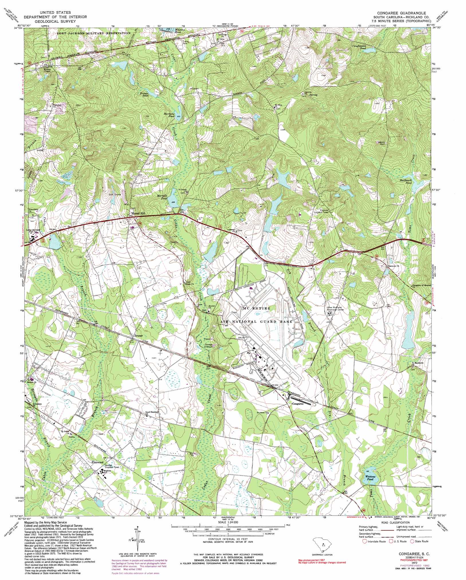
Congaree Topo Map South Carolina
To zoom in, hover over the map of Congaree
USGS Topo Quad 33080h7 - 1:24,000 scale
| Topo Map Name: | Congaree |
| USGS Topo Quad ID: | 33080h7 |
| Print Size: | ca. 21 1/4" wide x 27" high |
| Southeast Coordinates: | 33.875° N latitude / 80.75° W longitude |
| Map Center Coordinates: | 33.9375° N latitude / 80.8125° W longitude |
| U.S. State: | SC |
| Filename: | o33080h7.jpg |
| Download Map JPG Image: | Congaree topo map 1:24,000 scale |
| Map Type: | Topographic |
| Topo Series: | 7.5´ |
| Map Scale: | 1:24,000 |
| Source of Map Images: | United States Geological Survey (USGS) |
| Alternate Map Versions: |
Congaree SC 1953, updated 1957 Download PDF Buy paper map Congaree SC 1972, updated 1974 Download PDF Buy paper map Congaree SC 1972, updated 1982 Download PDF Buy paper map Congaree SC 1972, updated 1991 Download PDF Buy paper map Congaree SC 2011 Download PDF Buy paper map Congaree SC 2014 Download PDF Buy paper map |
1:24,000 Topo Quads surrounding Congaree
Irmo Ne |
Blythewood |
Elgin |
Lugoff |
Camden South |
Columbia North |
Fort Jackson North |
Messers Pond |
Leesburg |
Rembert |
Southwest Columbia |
Fort Jackson South |
Congaree |
Eastover |
Wedgefield |
Gaston |
Saylors Lake |
Gadsden |
Wateree |
Poinsett State Park |
Swansea |
Staley Crossroads |
Saint Mathews |
Fort Motte |
Lone Star |
> Back to 33080e1 at 1:100,000 scale
> Back to 33080a1 at 1:250,000 scale
> Back to U.S. Topo Maps home
Congaree topo map: Gazetteer
Congaree: Dams
Boyds Pond D-0592 Dam elevation 59m 193′Gwinns Pond D-0588 Dam elevation 90m 295′
Haithcock Pond D-0591 Dam elevation 73m 239′
Harmons Pond D-0585 Dam elevation 68m 223′
Jordans Pond D-0590 Dam elevation 64m 209′
Mandel Park Pond D-0584 Dam elevation 76m 249′
Morrells Pond D-0586 Dam elevation 63m 206′
Peelers Pond D-0589 Dam elevation 87m 285′
Reveres Pond D-0583 Dam elevation 66m 216′
South Carolina Noname 40043 D-0587 Dam elevation 98m 321′
Weston Lake Dam - Fort Jackson elevation 77m 252′
Westons Pond D-0593 Dam elevation 49m 160′
Congaree: Populated Places
Bruner elevation 65m 213′Congaree elevation 67m 219′
Deer Ridge Farms elevation 109m 357′
Green Lake Estates elevation 80m 262′
Harmon Estates elevation 137m 449′
Horrel Hill elevation 111m 364′
Pinewood elevation 50m 164′
San Marco Estates elevation 124m 406′
Swandale elevation 122m 400′
Congaree: Reservoirs
Boyds Pond elevation 59m 193′Caughmans Pond elevation 74m 242′
Gwinns Pond elevation 90m 295′
Haithcock Pond elevation 69m 226′
Harmons Pond elevation 68m 223′
Jordans Pond elevation 64m 209′
Jordans Pond elevation 76m 249′
Morrells Pond elevation 63m 206′
Reveres Pond elevation 66m 216′
Weston Lake elevation 77m 252′
Westons Pond elevation 49m 160′
Westons Pond elevation 83m 272′
Youngs Pond elevation 70m 229′
Congaree: Streams
Horsepen Branch elevation 38m 124′Congaree digital topo map on disk
Buy this Congaree topo map showing relief, roads, GPS coordinates and other geographical features, as a high-resolution digital map file on DVD:
South Carolina, Western North Carolina & Northeastern Georgia
Buy digital topo maps: South Carolina, Western North Carolina & Northeastern Georgia