Luxomni Topo Map Georgia
To zoom in, hover over the map of Luxomni
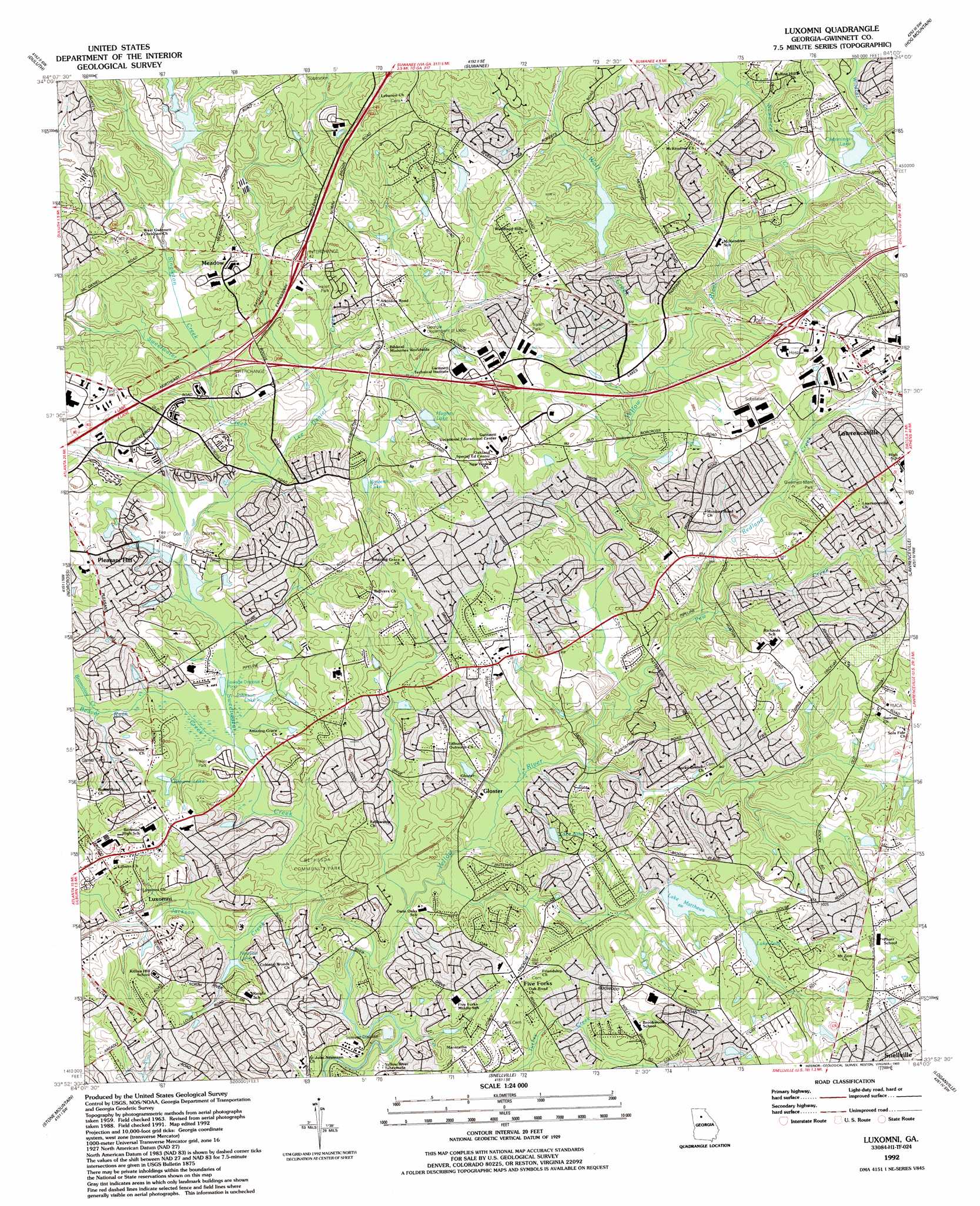
USGS Topo Quad 33084h1 - 1:24,000 scale
| Topo Map Name: | Luxomni |
| USGS Topo Quad ID: | 33084h1 |
| Print Size: | ca. 21 1/4" wide x 27" high |
| Southeast Coordinates: | 33.875° N latitude / 84° W longitude |
| Map Center Coordinates: | 33.9375° N latitude / 84.0625° W longitude |
| U.S. State: | GA |
| Filename: | o33084h1.jpg |
| Download Map JPG Image: | Luxomni topo map 1:24,000 scale |
| Map Type: | Topographic |
| Topo Series: | 7.5´ |
| Map Scale: | 1:24,000 |
| Source of Map Images: | United States Geological Survey (USGS) |
| Alternate Map Versions: |
Luxomni GA 1963, updated 1965 Download PDF Buy paper map Luxomni GA 1963, updated 1972 Download PDF Buy paper map Luxomni GA 1963, updated 1974 Download PDF Buy paper map Luxomni GA 1963, updated 1983 Download PDF Buy paper map Luxomni GA 1992, updated 1993 Download PDF Buy paper map Luxomni GA 1999, updated 2003 Download PDF Buy paper map Luxomni GA 2011 Download PDF Buy paper map Luxomni GA 2014 Download PDF Buy paper map |
1:24,000 Topo Quads surrounding Luxomni
Birmingham |
Cumming |
Buford Dam |
Flowery Branch |
Chestnut Mountain |
Roswell |
Duluth |
Suwanee |
Hog Mountain |
Auburn |
Chamblee |
Norcross |
Luxomni |
Lawrenceville |
Bold Springs |
Northeast Atlanta |
Stone Mountain |
Snellville |
Loganville |
Between |
Southeast Atlanta |
Redan |
Conyers |
Milstead |
Jersey |
> Back to 33084e1 at 1:100,000 scale
> Back to 33084a1 at 1:250,000 scale
> Back to U.S. Topo Maps home
Luxomni topo map: Gazetteer
Luxomni: Airports
Gwinnett Community Hospital Heliport elevation 306m 1003′Gwinnett Medical Center Heliport elevation 314m 1030′
Luxomni: Crossings
Interchange 41 elevation 280m 918′Interchange 42 elevation 298m 977′
Luxomni: Dams
Atha Dam elevation 286m 938′C and S Financial Corporation Dam elevation 301m 987′
Harris Dam Y15 elevation 290m 951′
Hughes Lake Dam elevation 286m 938′
Jones Dam Y14 elevation 295m 967′
Lake Matthews Dam elevation 284m 931′
Lake Zora Dam elevation 297m 974′
Lionel Lake Dam elevation 295m 967′
Rollins Ranch Lake Dam elevation 290m 951′
Sturdivant Lake Dam elevation 275m 902′
Luxomni: Lakes
Channings Lake elevation 290m 951′Luxomni: Parks
Bethesda Community Park elevation 276m 905′Luxomni: Populated Places
Ansley Brook elevation 290m 951′Bethesda elevation 296m 971′
Bridgewater elevation 296m 971′
Bristol Downs elevation 287m 941′
Brookwood Manor elevation 311m 1020′
Broxton Woods elevation 301m 987′
Burnt Creek elevation 281m 921′
Castle Courts elevation 275m 902′
Coopers Pond elevation 270m 885′
Cotton Creek elevation 320m 1049′
Countryside Village Mobile Home Park elevation 267m 875′
Cricket Hill elevation 292m 958′
Emerald Forest elevation 289m 948′
Fairfield Farms elevation 323m 1059′
Fairview Station elevation 314m 1030′
Five Forks elevation 299m 980′
Flowers Crossing elevation 298m 977′
Friendly Village of Crooked Creek elevation 289m 948′
Gloster elevation 271m 889′
Hanarry Estates elevation 303m 994′
Heritage Station elevation 293m 961′
Hunting Creek elevation 306m 1003′
Inglenook elevation 305m 1000′
Jackson Township elevation 299m 980′
La Mancha elevation 275m 902′
Lester Woods elevation 279m 915′
Luxomni elevation 268m 879′
Marsh Creek elevation 304m 997′
Meadow elevation 293m 961′
Murphy Estates elevation 280m 918′
Murphyville elevation 276m 905′
Oakbrook Forest elevation 307m 1007′
Oakland North elevation 291m 954′
Plantation Woods elevation 295m 967′
Pleasant Acres elevation 282m 925′
Pleasant Hill elevation 289m 948′
Purcell Valley elevation 298m 977′
Rambling Woods elevation 310m 1017′
Regal Estates elevation 326m 1069′
Regency Woods elevation 307m 1007′
River Bridge elevation 281m 921′
River Colony elevation 308m 1010′
River Oak elevation 290m 951′
Rolling Ridge elevation 275m 902′
Sioux Acres Mobile Home Park elevation 297m 974′
Steeplechase elevation 325m 1066′
Stone Mill elevation 307m 1007′
Summerville elevation 311m 1020′
Sweet Water elevation 287m 941′
The Wildings elevation 304m 997′
Yorktown elevation 320m 1049′
Luxomni: Post Offices
North Metro Facility Post Office elevation 284m 931′Patterson Road Post Office elevation 273m 895′
Luxomni: Reservoirs
Bowens Lake elevation 282m 925′Browne Lake elevation 274m 898′
C and S Financial Corporation Lake elevation 301m 987′
Harris Lake elevation 290m 951′
Hughes Lake elevation 286m 938′
Johnson Lake elevation 263m 862′
Jones Lake elevation 295m 967′
Lake Atha elevation 286m 938′
Lake Matthews elevation 283m 928′
Lake Zola elevation 290m 951′
Lake Zora elevation 297m 974′
Lionel Lake elevation 295m 967′
Newton Lake elevation 263m 862′
Rollins Ranch Lake elevation 290m 951′
Sturdivant Lake elevation 275m 902′
Luxomni: Streams
Beaver Ruin Creek elevation 257m 843′Bromolow Creek elevation 258m 846′
Jackson Creek elevation 257m 843′
Lee Daniel Creek elevation 266m 872′
Little Suwanee Creek elevation 281m 921′
Pew Creek elevation 269m 882′
Redland Creek elevation 274m 898′
Singleton Creek elevation 268m 879′
Sweetwater Creek elevation 252m 826′
Wildcat Creek elevation 289m 948′
Wolf Creek elevation 275m 902′
Luxomni digital topo map on disk
Buy this Luxomni topo map showing relief, roads, GPS coordinates and other geographical features, as a high-resolution digital map file on DVD: