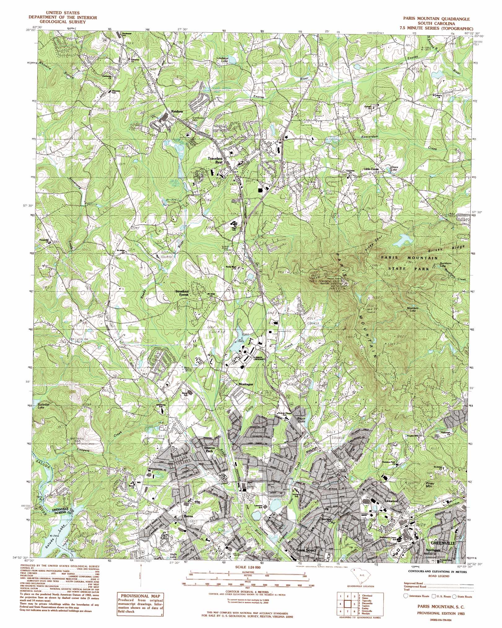
Paris Mountain Topo Map South Carolina
To zoom in, hover over the map of Paris Mountain
USGS Topo Quad 34082h4 - 1:24,000 scale
| Topo Map Name: | Paris Mountain |
| USGS Topo Quad ID: | 34082h4 |
| Print Size: | ca. 21 1/4" wide x 27" high |
| Southeast Coordinates: | 34.875° N latitude / 82.375° W longitude |
| Map Center Coordinates: | 34.9375° N latitude / 82.4375° W longitude |
| U.S. State: | SC |
| Filename: | o34082h4.jpg |
| Download Map JPG Image: | Paris Mountain topo map 1:24,000 scale |
| Map Type: | Topographic |
| Topo Series: | 7.5´ |
| Map Scale: | 1:24,000 |
| Source of Map Images: | United States Geological Survey (USGS) |
| Alternate Map Versions: |
Paris Mountain SC 1983, updated 1983 Download PDF Buy paper map Paris Mountain SC 1983, updated 1983 Download PDF Buy paper map Paris Mountain SC 1983, updated 1983 Download PDF Buy paper map Paris Mountain SC 2011 Download PDF Buy paper map Paris Mountain SC 2014 Download PDF Buy paper map |
1:24,000 Topo Quads surrounding Paris Mountain
Brevard |
Standingstone Mountain |
Zirconia |
Saluda |
Landrum |
Table Rock |
Cleveland |
Slater |
Tigerville |
Campobello |
Pickens |
Dacusville |
Paris Mountain |
Taylors |
Greer |
Liberty |
Easley |
Greenville |
Mauldin |
Pelham |
Five Forks |
Piercetown |
Pelzer |
Simpsonville |
Fountain Inn |
> Back to 34082e1 at 1:100,000 scale
> Back to 34082a1 at 1:250,000 scale
> Back to U.S. Topo Maps home
Paris Mountain topo map: Gazetteer
Paris Mountain: Bridges
Farrs Bridge elevation 261m 856′Paris Mountain: Dams
Bruce Lake Dam D-2857 elevation 305m 1000′Buckhorn Lake Dam D-2872 elevation 357m 1171′
Coleman Pond Dam D-2840 elevation 302m 990′
E Stone Pond Dam D-1402 elevation 327m 1072′
G Hughston Pond Dam elevation 305m 1000′
Kaufman Pond Number One Dam D-2855 elevation 549m 1801′
Lindsey Lake Dam D-2839 elevation 316m 1036′
Mountain Lake Dam D-2854 elevation 351m 1151′
Snyder Pond Dam D-2856 elevation 318m 1043′
South Carolina Noname 23004 D-2853 Dam elevation 364m 1194′
South Carolina Noname 23017 D-2841 Dam elevation 306m 1003′
South Carolina Noname 23021 D-2842 Dam elevation 302m 990′
South Carolina Noname 23029 D-2870 Dam elevation 304m 997′
Spence Pond Dam D-2868 elevation 312m 1023′
Stone Lake Dam D-2873 elevation 287m 941′
Paris Mountain: Lakes
Buckhorn Lake elevation 357m 1171′Paris Mountain: Parks
Paris Mountain State Park elevation 496m 1627′Travelers Rest City Park elevation 321m 1053′
Paris Mountain: Populated Places
Berea elevation 317m 1040′Berea Forest elevation 307m 1007′
Berea Heights elevation 324m 1062′
Brookgreen elevation 324m 1062′
Buxton elevation 333m 1092′
Cedar Lane Gardens elevation 299m 980′
Colonial Oaks Mobile Manor elevation 310m 1017′
Cope Heights elevation 308m 1010′
Dellhaven elevation 309m 1013′
High View Acres elevation 307m 1007′
Hillandale elevation 323m 1059′
Indian Hills elevation 310m 1017′
Leawood elevation 317m 1040′
Little Texas elevation 307m 1007′
Montague elevation 319m 1046′
Mountain Shadows elevation 306m 1003′
New Furman Heights elevation 309m 1013′
Northgate elevation 302m 990′
Northwood Hills elevation 319m 1046′
Oak Hills elevation 305m 1000′
Paris Point elevation 341m 1118′
Parkstone elevation 338m 1108′
Pinehurst elevation 321m 1053′
Points North elevation 327m 1072′
Renfrew elevation 331m 1085′
Richmond Hills elevation 300m 984′
Sans Souci elevation 309m 1013′
Sans Souci Heights elevation 315m 1033′
Sharon Park elevation 307m 1007′
Starsdale Manor elevation 323m 1059′
Stratford Forest elevation 333m 1092′
Sunny Acres elevation 318m 1043′
Sunny Slopes elevation 319m 1046′
Travelers Rest elevation 334m 1095′
Western Hills elevation 304m 997′
Paris Mountain: Reservoirs
Bruce Lake elevation 305m 1000′Buckhorn Lake elevation 320m 1049′
Coleman Pond elevation 302m 990′
Cone Mill Pond elevation 302m 990′
G Hughston Pond elevation 305m 1000′
Grace Lake elevation 309m 1013′
Jonah Pond elevation 304m 997′
Lindsey Lake elevation 316m 1036′
Lindseys Lake elevation 313m 1026′
Mountain Lake elevation 322m 1056′
Mountain Lake elevation 351m 1151′
Parris Mountain Holding Pond elevation 364m 1194′
Snyder Pond elevation 318m 1043′
Spence Pond elevation 312m 1023′
Stone Lake elevation 287m 941′
Stone Lake elevation 290m 951′
Swan Lake elevation 306m 1003′
Twin Lakes elevation 290m 951′
Paris Mountain: Ridges
Brissey Ridge elevation 408m 1338′Piney Spur elevation 436m 1430′
Paris Mountain: Streams
Coopers Creek elevation 260m 853′Langston Creek elevation 287m 941′
Little Creek elevation 291m 954′
North Enoree River elevation 285m 935′
Paris Mountain: Summits
Paris Mountain elevation 626m 2053′Piney Mountain elevation 414m 1358′
Paris Mountain digital topo map on disk
Buy this Paris Mountain topo map showing relief, roads, GPS coordinates and other geographical features, as a high-resolution digital map file on DVD:
South Carolina, Western North Carolina & Northeastern Georgia
Buy digital topo maps: South Carolina, Western North Carolina & Northeastern Georgia