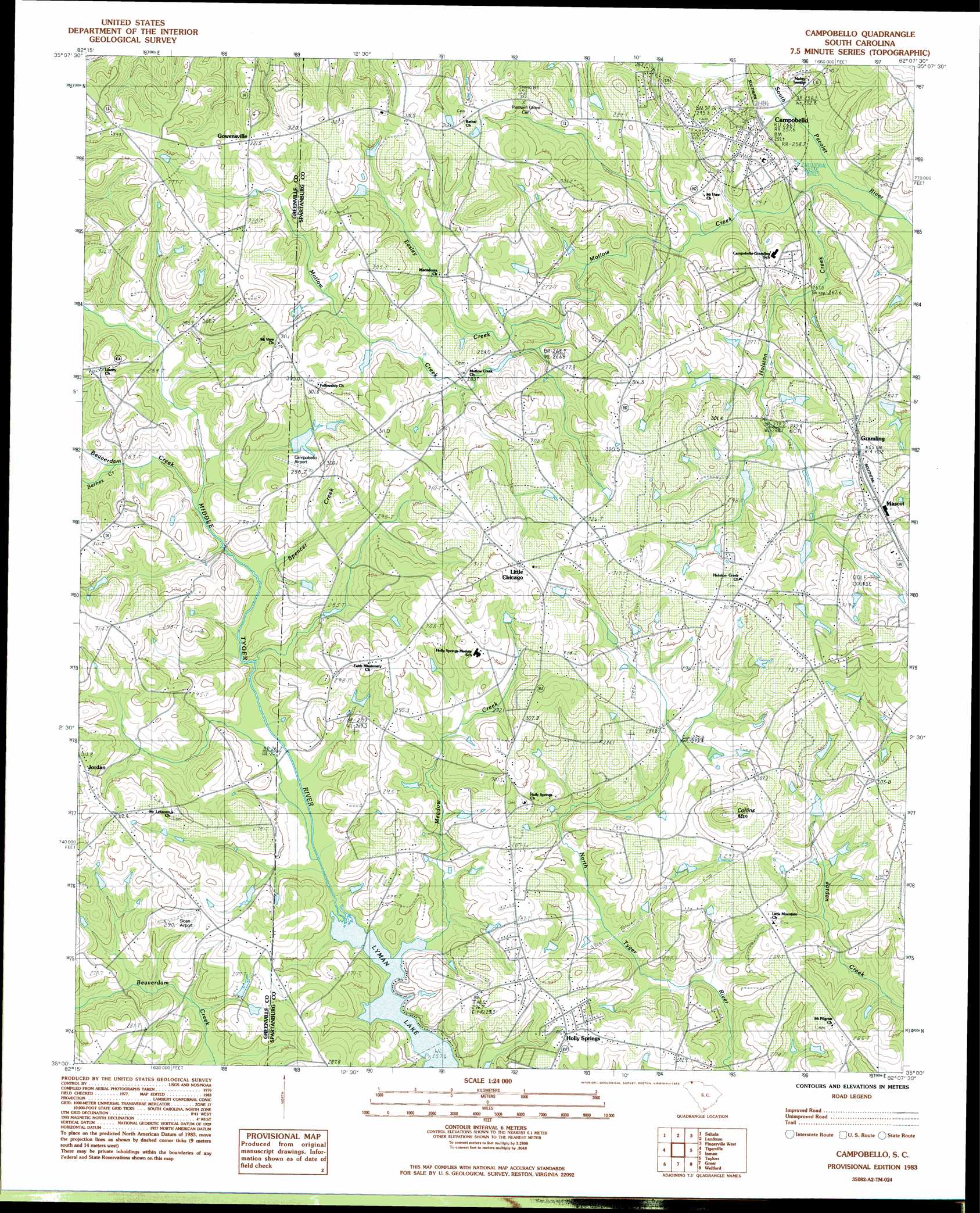
Campobello Topo Map South Carolina
To zoom in, hover over the map of Campobello
USGS Topo Quad 35082a2 - 1:24,000 scale
| Topo Map Name: | Campobello |
| USGS Topo Quad ID: | 35082a2 |
| Print Size: | ca. 21 1/4" wide x 27" high |
| Southeast Coordinates: | 35° N latitude / 82.125° W longitude |
| Map Center Coordinates: | 35.0625° N latitude / 82.1875° W longitude |
| U.S. State: | SC |
| Filename: | o35082a2.jpg |
| Download Map JPG Image: | Campobello topo map 1:24,000 scale |
| Map Type: | Topographic |
| Topo Series: | 7.5´ |
| Map Scale: | 1:24,000 |
| Source of Map Images: | United States Geological Survey (USGS) |
| Alternate Map Versions: |
Campobello SC 1983, updated 1983 Download PDF Buy paper map Campobello SC 2011 Download PDF Buy paper map Campobello SC 2014 Download PDF Buy paper map |
1:24,000 Topo Quads surrounding Campobello
Hendersonville |
Cliffield Mountain |
Mill Spring |
Pea Ridge |
Rutherfordton South |
Zirconia |
Saluda |
Landrum |
Fingerville West |
Fingerville East |
Slater |
Tigerville |
Campobello |
Inman |
Valley Falls |
Paris Mountain |
Taylors |
Greer |
Wellford |
Spartanburg |
Greenville |
Mauldin |
Pelham |
Reidville |
Moore |
> Back to 35082a1 at 1:100,000 scale
> Back to 35082a1 at 1:250,000 scale
> Back to U.S. Topo Maps home
Campobello topo map: Gazetteer
Campobello: Airports
Campobello Airport elevation 300m 984′Sloan Airport elevation 292m 958′
Campobello: Dams
Al Jones Pond Dam D-3339 elevation 270m 885′C Stewart Pond Dam D-3394 elevation 282m 925′
E Lee Incorporated Pond Dam D-3314 elevation 317m 1040′
E Woodfin Lake Dam D-3309 elevation 291m 954′
Gramling Brothers Lake Dam Five D-3311 elevation 294m 964′
Gramling Pond Dam Number One D-3307 elevation 293m 961′
Gramling Pond Number Four Dam D-3393 elevation 275m 902′
Gramling Pond Number Two Dam D-3308 elevation 278m 912′
H B Davis Pond Dam D-3318 elevation 283m 928′
J B Johnson Pond Dam D-3315 elevation 319m 1046′
Professional Pond Dam D-3317 elevation 300m 984′
T Cribb Pond Dam D-2175 elevation 306m 1003′
T Ragan Pond Dam D-3316 elevation 302m 990′
Vaughn Pond Dam D-2910 elevation 282m 925′
Campobello: Mines
Lyman Quarry elevation 280m 918′Campobello: Populated Places
Andover (historical) elevation 312m 1023′Campobello elevation 281m 921′
Gowensville elevation 322m 1056′
Gramling elevation 305m 1000′
Holly Springs elevation 288m 944′
Little Chicago elevation 330m 1082′
Mascot elevation 313m 1026′
Tyger (historical) elevation 310m 1017′
Campobello: Reservoirs
C Stewart Pond elevation 282m 925′E Lee Incorporated Pond elevation 317m 1040′
E Woodfin Lake elevation 291m 954′
Gramling Number One Pond elevation 293m 961′
H B Davis Pond elevation 283m 928′
J B Johnson Pond elevation 319m 1046′
Professional Pond elevation 300m 984′
T Cribb Pond elevation 306m 1003′
T Ragan Pond Dam elevation 302m 990′
Vaughn Pond elevation 282m 925′
Campobello: Streams
Beaverdam Creek elevation 282m 925′Beaverdam Creek elevation 281m 921′
Holston Creek elevation 260m 853′
Meadow Creek elevation 258m 846′
Motlow Creek elevation 252m 826′
Resin Creek elevation 264m 866′
Campobello: Summits
Collins Mountain elevation 345m 1131′Campobello digital topo map on disk
Buy this Campobello topo map showing relief, roads, GPS coordinates and other geographical features, as a high-resolution digital map file on DVD:
South Carolina, Western North Carolina & Northeastern Georgia
Buy digital topo maps: South Carolina, Western North Carolina & Northeastern Georgia