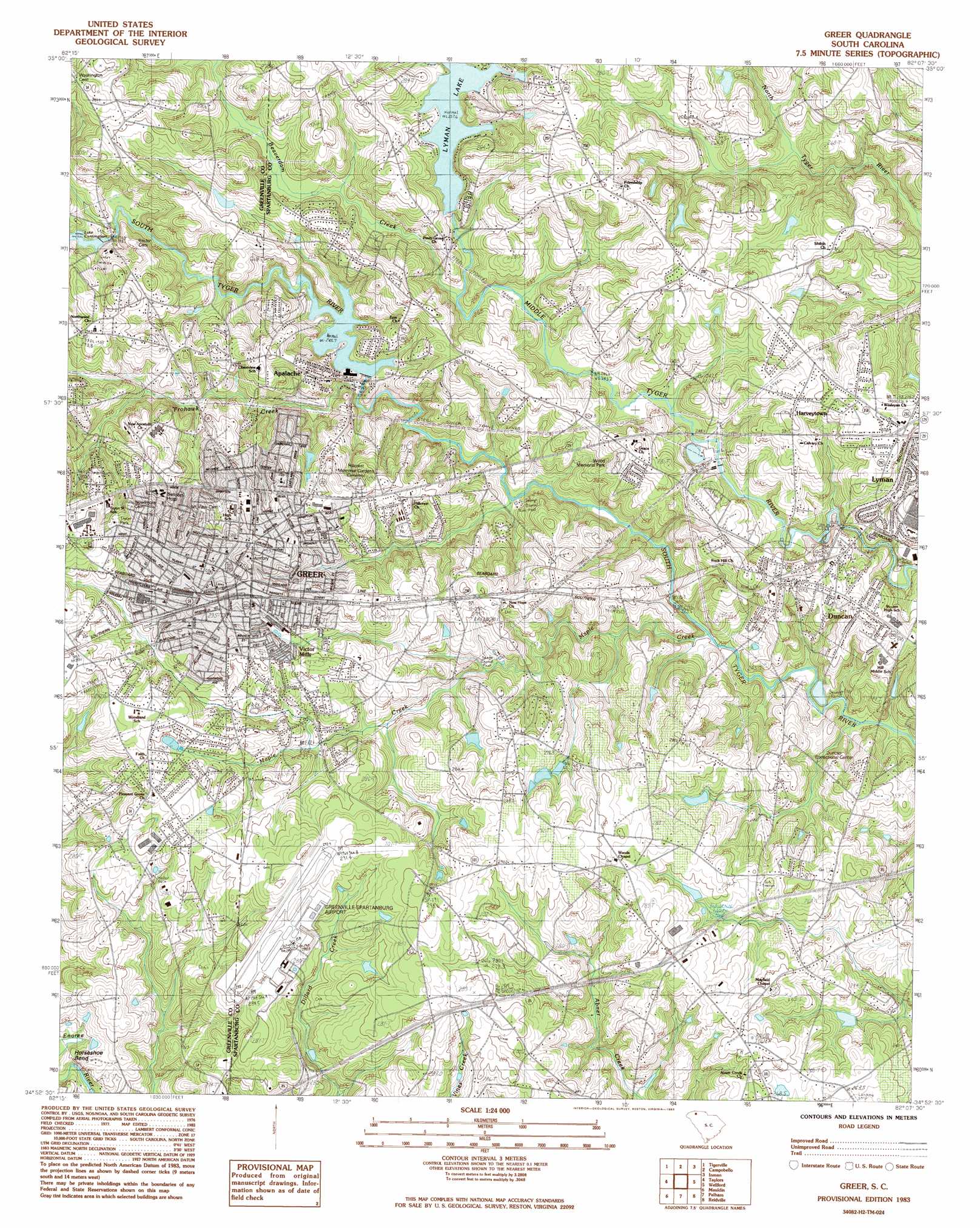
Greer Topo Map South Carolina
To zoom in, hover over the map of Greer
USGS Topo Quad 34082h2 - 1:24,000 scale
| Topo Map Name: | Greer |
| USGS Topo Quad ID: | 34082h2 |
| Print Size: | ca. 21 1/4" wide x 27" high |
| Southeast Coordinates: | 34.875° N latitude / 82.125° W longitude |
| Map Center Coordinates: | 34.9375° N latitude / 82.1875° W longitude |
| U.S. State: | SC |
| Filename: | o34082h2.jpg |
| Download Map JPG Image: | Greer topo map 1:24,000 scale |
| Map Type: | Topographic |
| Topo Series: | 7.5´ |
| Map Scale: | 1:24,000 |
| Source of Map Images: | United States Geological Survey (USGS) |
| Alternate Map Versions: |
Greer SC 1983, updated 1983 Download PDF Buy paper map Greer SC 1994, updated 2000 Download PDF Buy paper map Greer SC 2011 Download PDF Buy paper map Greer SC 2014 Download PDF Buy paper map |
1:24,000 Topo Quads surrounding Greer
Zirconia |
Saluda |
Landrum |
Fingerville West |
Fingerville East |
Slater |
Tigerville |
Campobello |
Inman |
Valley Falls |
Paris Mountain |
Taylors |
Greer |
Wellford |
Spartanburg |
Greenville |
Mauldin |
Pelham |
Reidville |
Moore |
Pelzer |
Simpsonville |
Fountain Inn |
Woodruff |
Enoree |
> Back to 34082e1 at 1:100,000 scale
> Back to 34082a1 at 1:250,000 scale
> Back to U.S. Topo Maps home
Greer topo map: Gazetteer
Greer: Airports
Greenville-Spartanburg Airport elevation 288m 944′Greer: Bends
Horseshoe Bend elevation 255m 836′Greer: Bridges
Dantzler Bridge elevation 230m 754′Greer: Crossings
Interchange 57 elevation 275m 902′Interchange 60 elevation 289m 948′
Greer: Dams
Alverson Pond Dam elevation 251m 823′F McMackin Pond Dam D-3341 elevation 270m 885′
L M Dobson Pond Dam D-2743 elevation 262m 859′
Moon Pond Dam D-2911 elevation 262m 859′
R A Dodson Pond Dam D-3343 elevation 282m 925′
R E Collins Pond Dam D-3337 elevation 276m 905′
Robinson Farms Pond Number One Dam D-2746 elevation 282m 925′
Robinson Farms Pond Number Two Dam D-2747 elevation 260m 853′
South Carolina Noname 42001 Dam elevation 244m 800′
South Carolina Noname 42004 D-3340 Dam elevation 261m 856′
W D Glenn Pond Dam D-3344 elevation 277m 908′
Greer: Parks
Apalache Park elevation 244m 800′Ben Edward Park elevation 286m 938′
Century Park elevation 289m 948′
City Park elevation 303m 994′
Davenport Park elevation 313m 1026′
Greentown Park elevation 295m 967′
Rotary Park elevation 303m 994′
Springwood Park elevation 309m 1013′
Stephens Park elevation 288m 944′
Sunnyside Park elevation 292m 958′
Tryon Park elevation 310m 1017′
Turner Park elevation 300m 984′
Victor Park elevation 282m 925′
Wards Creek Park elevation 252m 826′
Greer: Populated Places
Apalache elevation 250m 820′Bonaire Acres elevation 298m 977′
Brookdale elevation 262m 859′
Brookhaven elevation 292m 958′
Calina Heights elevation 255m 836′
Chapel Estates elevation 271m 889′
Cheryl Fields elevation 261m 856′
Cokes Ridge Mobile Home Park elevation 245m 803′
Country Club Estates elevation 277m 908′
Cove Subdivision elevation 286m 938′
Crestview Hills elevation 274m 898′
Dogwood Acres elevation 287m 941′
Duncan elevation 264m 866′
Fairway Estates elevation 257m 843′
Forest Hills elevation 262m 859′
Fulton Acres elevation 303m 994′
Galloway Trailer Park elevation 256m 839′
Greer elevation 312m 1023′
Harveytown elevation 284m 931′
Holiday Hills elevation 289m 948′
Holly Hill Heights elevation 278m 912′
Homewood Acres elevation 292m 958′
Lakeview Heights elevation 285m 935′
Lakewood Hills elevation 263m 862′
Lyman elevation 270m 885′
Manning Acres elevation 276m 905′
Maple elevation 280m 918′
Maplewood elevation 273m 895′
Mink Creek Estates elevation 280m 918′
Northview Acres elevation 287m 941′
Oakwood elevation 266m 872′
Palmetto Estates elevation 257m 843′
Pinecrest elevation 255m 836′
Pleasant Grove elevation 295m 967′
Serene Heights elevation 279m 915′
Sunny Glen elevation 257m 843′
Teton Forest elevation 279m 915′
Tyger elevation 272m 892′
Victor Heights elevation 288m 944′
Victor Mills elevation 287m 941′
Victorian Hills elevation 282m 925′
Wade Hampton Heights elevation 247m 810′
Woodland Forest elevation 271m 889′
Zoar Heights elevation 277m 908′
Greer: Post Offices
Greer Post Office elevation 309m 1013′Greer: Reservoirs
Alverson Pond elevation 251m 823′Apalachee Mill Pond elevation 244m 800′
Greer Reservoir elevation 258m 846′
Lyman Lake elevation 261m 856′
Moon Pond elevation 262m 859′
Greer: Streams
Beaverdam Creek elevation 264m 866′Frohawk Creek elevation 241m 790′
Maple Creek elevation 228m 748′
Victor Creek elevation 257m 843′
Wards Creek elevation 236m 774′
Greer digital topo map on disk
Buy this Greer topo map showing relief, roads, GPS coordinates and other geographical features, as a high-resolution digital map file on DVD:
South Carolina, Western North Carolina & Northeastern Georgia
Buy digital topo maps: South Carolina, Western North Carolina & Northeastern Georgia