Advance Topo Map North Carolina
To zoom in, hover over the map of Advance
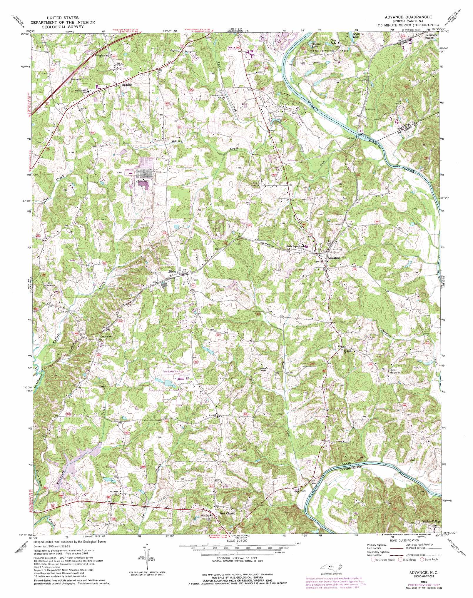
USGS Topo Quad 35080h4 - 1:24,000 scale
| Topo Map Name: | Advance |
| USGS Topo Quad ID: | 35080h4 |
| Print Size: | ca. 21 1/4" wide x 27" high |
| Southeast Coordinates: | 35.875° N latitude / 80.375° W longitude |
| Map Center Coordinates: | 35.9375° N latitude / 80.4375° W longitude |
| U.S. State: | NC |
| Filename: | o35080h4.jpg |
| Download Map JPG Image: | Advance topo map 1:24,000 scale |
| Map Type: | Topographic |
| Topo Series: | 7.5´ |
| Map Scale: | 1:24,000 |
| Source of Map Images: | United States Geological Survey (USGS) |
| Alternate Map Versions: |
Advance NC 1969, updated 1972 Download PDF Buy paper map Advance NC 1969, updated 1987 Download PDF Buy paper map Advance NC 2010 Download PDF Buy paper map Advance NC 2013 Download PDF Buy paper map Advance NC 2016 Download PDF Buy paper map |
1:24,000 Topo Quads surrounding Advance
Yadkinville |
East Bend |
Vienna |
Rural Hall |
Walkertown |
Lone Hickory |
Farmington |
Clemmons |
Winston-Salem West |
Winston-Salem East |
Calahaln |
Mocksville |
Advance |
Welcome |
Midway |
Cool Springs |
Cooleemee |
Churchland |
Lexington West |
Lexington East |
Cleveland |
Rowan Mills |
Salisbury |
Southmont |
Denton Nw |
> Back to 35080e1 at 1:100,000 scale
> Back to 35080a1 at 1:250,000 scale
> Back to U.S. Topo Maps home
Advance topo map: Gazetteer
Advance: Airports
Strawberry Hill Airport elevation 230m 754′Twin Lakes Airport elevation 246m 807′
Advance: Dams
Idols Dam elevation 208m 682′T Holt Haywood Dam elevation 209m 685′
Advance: Lakes
Skilpot Lake elevation 210m 688′Advance: Parks
Tanglewood Park elevation 243m 797′Yadkin College Historic District elevation 239m 784′
Advance: Populated Places
Advance elevation 251m 823′Bixby elevation 252m 826′
Clemmons Station elevation 241m 790′
Cornatzer elevation 243m 797′
Country Cove elevation 259m 849′
Elbaville elevation 246m 807′
Fork elevation 248m 813′
Fulton (historical) elevation 199m 652′
Heidleberg Settlement elevation 241m 790′
Hickory Hill elevation 208m 682′
Mount Zion elevation 240m 787′
Muddy Creek elevation 245m 803′
Raintree Estates elevation 225m 738′
Redland elevation 265m 869′
Advance: Post Offices
Dulins Post Office (historical) elevation 222m 728′Fork Church Post Office elevation 248m 813′
Advance: Reservoirs
Coon Lake elevation 223m 731′Dutchmans Creek Lake elevation 209m 685′
Idols Reservoir elevation 208m 682′
Advance: Streams
Bailey Creek elevation 209m 685′Buffalo Creek elevation 201m 659′
Carter Creek elevation 202m 662′
Carters Creek elevation 202m 662′
Ellsworth Creek elevation 198m 649′
Fulton Creek elevation 197m 646′
Peoples Creek elevation 203m 666′
Smith Creek elevation 211m 692′
Advance digital topo map on disk
Buy this Advance topo map showing relief, roads, GPS coordinates and other geographical features, as a high-resolution digital map file on DVD:
South Carolina, Western North Carolina & Northeastern Georgia
Buy digital topo maps: South Carolina, Western North Carolina & Northeastern Georgia