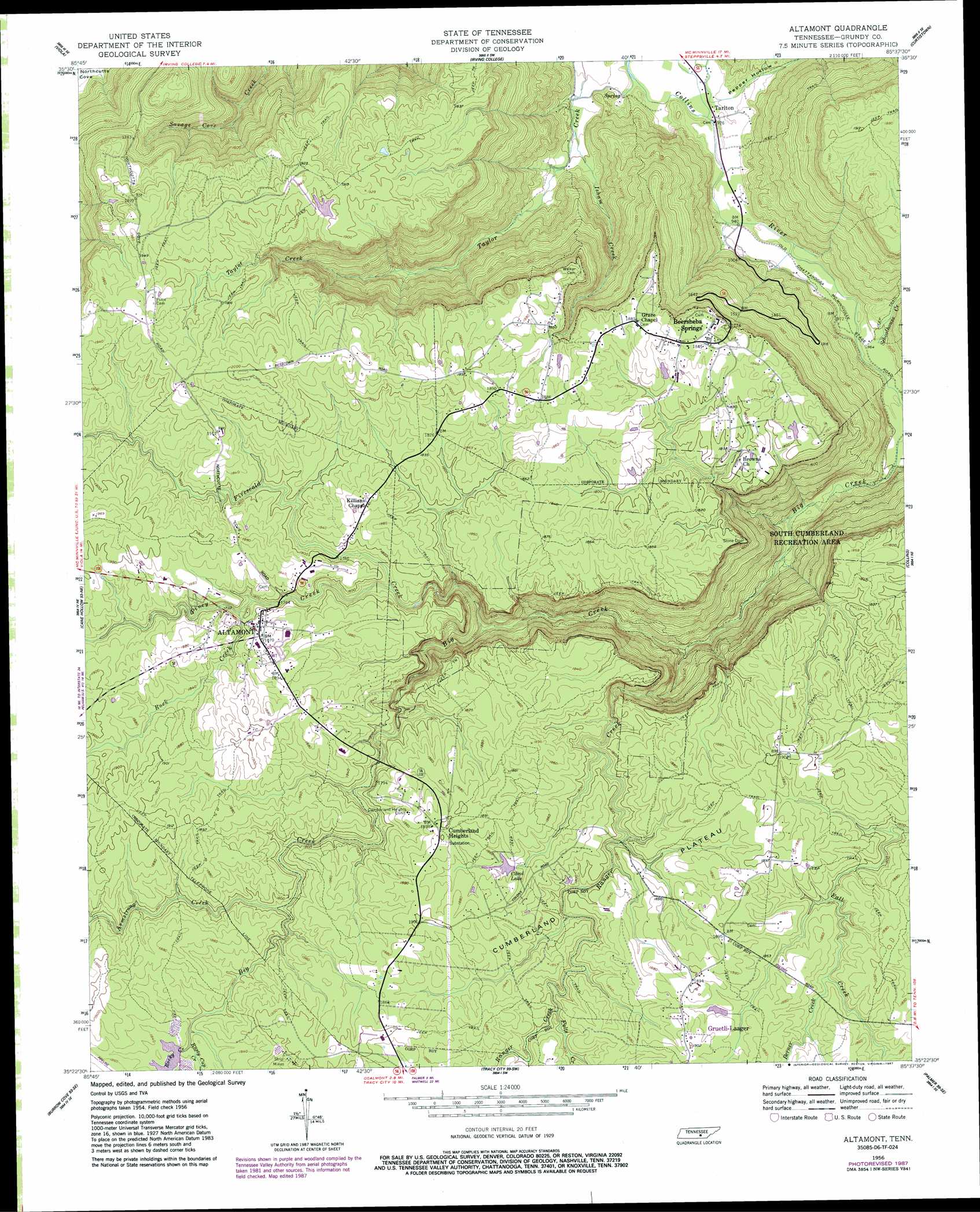
Altamont Topo Map Tennessee
To zoom in, hover over the map of Altamont
USGS Topo Quad 35085d6 - 1:24,000 scale
| Topo Map Name: | Altamont |
| USGS Topo Quad ID: | 35085d6 |
| Print Size: | ca. 21 1/4" wide x 27" high |
| Southeast Coordinates: | 35.375° N latitude / 85.625° W longitude |
| Map Center Coordinates: | 35.4375° N latitude / 85.6875° W longitude |
| U.S. State: | TN |
| Filename: | o35085d6.jpg |
| Download Map JPG Image: | Altamont topo map 1:24,000 scale |
| Map Type: | Topographic |
| Topo Series: | 7.5´ |
| Map Scale: | 1:24,000 |
| Source of Map Images: | United States Geological Survey (USGS) |
| Alternate Map Versions: |
Altamont TN 1956, updated 1957 Download PDF Buy paper map Altamont TN 1956, updated 1968 Download PDF Buy paper map Altamont TN 1956, updated 1979 Download PDF Buy paper map Altamont TN 1956, updated 1987 Download PDF Buy paper map Altamont TN 1956, updated 1987 Download PDF Buy paper map Altamont TN 1997, updated 1999 Download PDF Buy paper map Altamont TN 2010 Download PDF Buy paper map Altamont TN 2013 Download PDF Buy paper map Altamont TN 2016 Download PDF Buy paper map |
1:24,000 Topo Quads surrounding Altamont
Centertown |
Mcminnville |
Cardwell Mountain |
Welchland |
Spencer |
Morrison |
Viola |
Irving College |
Curtistown |
Smartt Mountain |
Hillsboro |
Cane Hollow |
Altamont |
Collins |
Savage Point |
Alto |
Burrow Cove |
Tracy City |
Palmer |
Daus |
Sewanee |
Monteagle |
White City |
Whitwell |
Ketner Gap |
> Back to 35085a1 at 1:100,000 scale
> Back to 35084a1 at 1:250,000 scale
> Back to U.S. Topo Maps home
Altamont topo map: Gazetteer
Altamont: Dams
Carol Dam elevation 548m 1797′Parker Dam elevation 558m 1830′
Altamont: Oilfields
Gruetli Gas Field elevation 566m 1856′Altamont: Pillars
Stone Door elevation 501m 1643′Altamont: Populated Places
Altamont elevation 565m 1853′Beersheba Springs elevation 563m 1847′
Cumberland Heights elevation 578m 1896′
Purdons (historical) elevation 577m 1893′
Tarlton elevation 280m 918′
Altamont: Reservoirs
Carol Lake elevation 548m 1797′Parker Lake elevation 558m 1830′
Altamont: Streams
Armstrong Creek elevation 540m 1771′Berner Creek elevation 552m 1811′
Big Creek elevation 548m 1797′
Firescald Creek elevation 441m 1446′
Fults Creek elevation 542m 1778′
Isham Creek elevation 298m 977′
Piney Creek elevation 532m 1745′
Ranger Creek elevation 353m 1158′
Rock Creek elevation 543m 1781′
Rocky Creek elevation 552m 1811′
Rusty Cup Creek elevation 550m 1804′
Schoolhouse Creek elevation 298m 977′
Altamont: Valleys
Pepper Hollow elevation 283m 928′Altamont digital topo map on disk
Buy this Altamont topo map showing relief, roads, GPS coordinates and other geographical features, as a high-resolution digital map file on DVD: